ANTIQUE MAPS OF AUSTRIA

Enjoy looking at this selection of fine Austrian maps. Please ask us if you are looking for a special map for your collection.

Ordering and payment.

Unsere Oesterreich Abteilung ist um ein Vielfaches grösser als hier erscheint. Sie können auch mit EURO bezahlen.

“Carinhtiae Ducatus, et Goritiae Palatinatus". “Histriae Tabula". “Zarae et Sebenici Descriptio". Three maps on one page. Copper etchings. Good recent hand coloring. Published in Abraham Ortelius: “Theatrum Orbis Terrarum" 1598.

Left half devoted to Carinthia in Austria. Right side divided to equal parts between the peninsula of Istria and the area of Zadar in Croatia. On half of the reverse side is text in Latin about the areas shown on the map.

Wide margins. General age toning. Margins partially spotty. Nice overall condition.

Page size: 45 x 56.5 cm (17.7 x 22.2").

$ 800.00

Order Nr. AUSTRIA1035


"Le Tirol, Souz le nom duqel s'entendent Le Comté De Tirol; puis les Comtés de Bregentz, Feldkirk, Montfort, Pludentz, & Sujets; et les Evesches de Trente, et Brixen ein protection des Comtes de Tirol." Copper etching by Sanson d'Abbeuille, dated 1654. Fine, modern hand coloring.

This map shows the extension of Tirol in the middle of the 17th century. In the upper left is Lake Constance and in the upper right is Salzburg and the Salzach River. Above the title cartouche is San Daniele and Belluno. To the left of the cartouche is Vicenza. Lago di Garda is in the lower center area and Lago di Como in the lower left. Almost in the center is Meran with Innsbruck a bit further north.

Map has wide margins. Vertical centerfold. Hand-written ink numbers in upper corners. General condition is otherwise Almost Very Good.

35.5 x 46.2 cm ( 17.9 x 18.1 ")

$ 920.00

Order Nr. AUSTRIA1015


"Theil von Tyrol. Sect. 175 Partie du Tyrol". Copper engraving published in Weimar by the Georgraph. Institut, 1804.

Very detailed map with Innsbruck and Hall in the center. In the upper left are the Thor Spitz and part of the Imau River with Mittenwald a bit to the right. In the lower left is the Mutterberger See and the Schran Kogl. In the upper left is Rattenberg. In the lower right is the Ahorn Spitze and Dreng Spitze.

Map has very wide margins. some light fraying on margin edges as well as a few small repaired tears on margin edges. Minimal spots in margins.

31 x 41 cm ( 12.2 x 16.1 ")

$ 180.00

Order Nr. AUSTRIA1020


"Exactissima Ducatus Carnilae Vinidorum Marchia et Histriae delineatio cura et caelo". Copper engraving by. Tob. Conr. Lotter, ca 1750. Fine hand coloring.

Ljubljana (Laubach) is in the upper center of this very detailed map. In the lower left is an inset with Czirnizer Lake and surrounding area. To the right of this inset is a coat-of-arms. The map reaches as far south as the island of Pag in the Adriatic Sea. On the right side is the confluence of the Sava and Unna Rivers. In the upper right is a decorative cartouche showing an allegoric country scene.

Map has a vertical centerfold that has been reinforced on backside so that it is flattened and does not fold. Some light browning along this centerfold. Map has narrow margins ca 1 cm wide as show on the photo against a white backgraound. Very minimal spotting. The image of the map is very fine.

49 x 57 cm ( 19.2 x 22.4 ")

$ 520.00

Order Nr.SLOVENIA 2416


"Kronland Tyrol. u. Vorarlberg und souveraines Fuerstenthum Liechtenstein." Lithograph vy H. Mueller for C. Flemming ca 1860. Some original hand outline coloring corresponging to the political regions listed in the lower right map key.

In the center of this very detailed topographical map is Meran. The map extends as far sout as Lago di Garda and as far north to Schongau and Weilheim in Oberbayern. In the upper right corner of the map is St. Gildgen and in the upper left corner is Ravenstein and Bodensee. In the lower left is a list of the highest mountains on the map.

Map has a few very light stains in margins and a small piece of lower left corner is mising. Light crease in upper left margins corner.

32 x 39.7 cm ( 12.5 x 15.6 ")

$ 75.00

Order Nr. AUSTRIA1031


"Steiermark, Kaernten, Krain." Lithograph by E. Serth for Tr. Bromme's Hand Atlas ca 1870. Partially printed in color with original hand outlining. Outline colors match with the key in the lower right corn showing the various regions.

Almost in the center of the map is Neumarkt in Krain. The lower pink area is Istrien (Croatia) with its many islands. In the upper right corner is Wiener Neustadt. Traunstein in Oberbayern is in the upper left corner.

Map has horizontal centerfold. Repair in left margin on centerfold. Two tiny repaired tears on lower margin edge.

37.5 x 28.5 cm ( 14.7 x 11.2 ")

$ 60.00

Order Nr. AUSTRIA1032


"Die Kronlaender Oesterreich Unter Und Ob der Enns Und Salzburg". Lithograph by A. Theinert for C. Flemming ca 1860. Some original hand outline coloring.

Steyer is located in the center of this informative regional map. The map extends from Achen See on the left to Pressburg on the right. Steyr is in the center of the map. In the upper left corner is a list of the major mountains on the map.

Map has a few minor repairs on outer margin edges.

30 x 40.5 cm ( 11.8 x 15.9 ")

$ 75.00

Order Nr. AUSRIA1033


"Archiducatus Austriae Inferioris accuratissima tabula...." Copper engraving by M. Seutter, ca 1740. Hand coloring.

Very detailed map with the course of the Danube in the upper middle area. On the left the Danube enters at Enns and Steyr and flows out on the right side at Presburg. In the upper left corner is Rudolfstadt in Bohemia. In the upper right is Landtshut and Goding on the Moravia River. In the lower left is Rottenman in Styria. In the lower right near the cherubs is Pinkenfeldt and Friburg. Decorative cartouche.

Map has some light browning in margins and light smudging in lower right margins and cartouche. Vertical centerfold.

49.5 x 58 cm ( 19.4 x 22.8)

$620.00

Order Nr. AUSTRIA1026


"Salisburgensis iurisdictionis locorumque vicinorum vera descriptio, auctore Marco Secznagel Salisburgense" Copper engraving by Marco Secznagel for the "Theatrum orbis terrarum" by Abraham Ortelius, ca 1580. Original hand coloring.

A beautiful map showing Salzburger Land and a charming historical view of Salzburg. The map is west oriented so that "north" is on the right side.In the upper right is part of the course of the Inn River and a bit lower the Salzach River. In the lower left is part of the Drau river. In the center of the map is Zell See. One half of backside is printed (in Latin) with text about Salzburg.

Margins have scattered spotting. Small repair in the are of the view of Salzburg that is hardly visible, except on the backside. Small repaired holes in lower margin on centerfold.

33.5 x 43.2 cm ( 13.1 x 17 ")

$ 1780.00

Order Nr.AUSTRIA1820 SOLD


"Salisburgensis iurisdictionis locorumque vicinorum vera descriptio, auctore Marco Secznagel Salisburgense" Copper engraving by Marco Secznagel for the "Theatrum orbis terrarum" by Abraham Ortelius, ca 1600. Original hand coloring.

The map is west oriented so that "north" is on the right side.In the upper right is part of the course of the Inn River and a bit lower the Salzach River. In the lower left is part of the Drau river. In the center of the map is Zell See. One half of backside is printed (in Latin) with text about Salzburg.

Map has a few light spots in margins -one larger spot in lower right margin corner. Tiny repaired hole on right border. a few hardly noticeable creases.

37.9 x 46.2 cm ( 14.9 x 18.1 ")

$1550.00

Order nr. AUSTRIA1024


"Österreichische Crais, Chrf. u. Herzogt. Bayern ". Copper etching by Tobias Conrad Lotter ( (1717-1777) after Tobias Lobeck for the "Atlas Geographicus portabilis" (Pocket-size atlas) published 1760-1762. Original hand coloring.

Salzburg is almost excactly in the center of this map reaching as far south as Padua and Bescia. In the north is Bamberg and Prague.

In the upper left is Wertheim and Rotenberg. Lake Como is in the lower left and Croatia in the lower right. In the upper right corner is Schoenberg und Olmutz.

A few light creases in map image. Browning in right margin.

9.5 x 12.2 cm ( 3.7 x 4.8 ")

$ 280.00

Order Nr. D1334


"Goritiae, Karstii, Chaczeolae, Carnilae, Histriae, et Windorum Marchae Descript. " Copper etching after Wolfgang Lazius by Abraham Ortelius in very fine, modern, hand coloring. From the atlas "Theatrum Orbis Terrarum" by Abraham Ortelius. Published ca 1580.

Map is north oriented. On the left side is part of Carinthis is the upper left and abit lower is Goriza and then the Gulf of Trieste. The Istrian peninsula with the ancient names of its cities and towns points south into the Adriatic Sea. The islands in the lower right have their ancient names of Vegia, Arbi, Cigola and Osero. The lake shown is Lake Zirknitzer, the size much larger than it actually is. In the upper right is part of Styria

Margins are wide except the left margin is narrow as this map was on a page with the Rhaetia map. The map was not printed straight on the page. This is not disturbing by fine, antique maps. Small, repaired tear on lower margin edge. The image of the map is in very fine condition.

34 x 23 cm ( 13.3 x 9 ")

$550.00

Order Nr. CROATIA2435


"Karstia, Carniola, Histria et Windorum Marchia". Copper etching by Johann Janssonius (+ 1666) in original
coloring. Amsterdam, ca. 1640.

Slovenia and the northern part of Dalmatia dominate this map. In the west is Friaul and the area around Udine. In the north
we see part of the course of the river Drau in Austria. The penninsula of Istria has oversized contours. Many of the islands
of the northern Adriatic Sea are shown. Verso: Text in German

General browning, the right part of the lower margin is very thumbed and has been strengthened. Condition: Good

38 x 49.3 cm (15 x 19.4 ")

$ 690.00

Order Nr. AUSTRIA1007


"Contea Principesca Del Titolo". Steel engraving from an Italian source ca 1850. Original hand outline coloring.

Map shows the area of Tyrol with Lake Constance in the Upper left. On the right side is Kitzbuehel and Lienz. At the bottom is Lake Garda with Verona and Peschiera.

Map has a few light scattered spots especially in the margins near margin edges. A few light creases. In the lower right margin corner is a printer's stamp. Light uneveness in the paper.

31.5 x 20 cm ( 12.4 x 7.8 ")

$ 185.00

Order Nr. ITALIA1466


"Erz-Herzogthum Oesterreich: Unter der Enns". Steel etching from "Neuster Zeitungs Atlas. Alter und Neuer Erdkunde" by J. Meyer, ca 1855. Original outline coloring.

The upper part of the map shows Austria with the surrounding countries. Vienna is in the right middle area. The Donau at Enns "flows" in about the middle of the left side. In the lower left is a detailed plan of Vienna dated 1850. In the lower right are detailed plans of Neustadt and Baaden.

Print has wide margins. In upper left margin is a hand-written number. Minimal spotting and smudging in margins. The date under the title of the upper image has been partially erased. General condition is Better than Good.

24.5 x 18.5 cm ( 9.6 x 7.3 ")

$ 80.00

Order Nr. AUSTRIA1012


“Grafschaft Tyrol". Steel engraving with original outline coloring. From “Zeitungs-Atlas fuer alte und neue Erdkunde". Published by J. Meyer. Hildburghausen, Amsterdam and New York. 1852

North-, East- and South-Tyrol. Tyrol in its largest extension. Left and right explanatory text.

General age toning. Margions are a bit spotty

19.5 x 25 cm (7.7 x 9.8")

$ 100.00

Nr. AUSTRIA1030


"Erz-Herzogthum Oesterreich: Ob Der Enns 1838. Steel etching from "Neuster Zeitungs Atlas. Alter und Neuer Erdkunde" by J. Meyer, ca 1855. Original outline coloring.

The Wolgangsee is in the center of this very detailed map. At the top of the map is Schwarzenberg and Ulrichsberg. In the lower right is an inset with a detailed plan of Linz and surrounding area.

Map has a few light spots.

18.5 x 24.8 cm ( 7.2 x 9.7 ")

$ 80.00

Order Nr. AUSTRIA1028


"Tyrol 1856" Steel etching from "Neuster Zeitungs Atlas. Alter und Neuer Erdkunde" by J. Meyer, ca 1855. Original outline coloring.

Meran is in the center of this map that reaches as far south as Garda Lake. In the north is Kufstein and in the upper left corner is part of Lake Constance.

Map has hardly visible vertical centerfold. Very light age toning. Repaired tear on lower margin edge.

19.5 x 25.3 cm ( 7.6 x 9.9 ")

$ 80.00

Order nr. AUSTRIA1027 SOLD


Herzogthum Steyermark". Steel etching by J. Graessl from "Neuster Zeitungs Atlas. Alter und Neuer Erdkunde" by J. Meyer, 1858. Original outline coloring.

Nice detailed map of Styria, especiall care detail of the mountains.

Map has pleasant age toning. Minor spotting in margins.

25.8 x 21.2 cm ( 10.1 x 8.3 ")

$ 80.00

Order nr. AUSTRIA1036


"Oesterreich 1849" Steel etching from "Neuster Zeitungs Atlas. Alter und Neuer Erdkunde" by J. Meyer, ca 1855. Original outline coloring.

Vienna and Presburg are in the center of this map that reaches as far east as Lemberg and Hermannstadt. In the upper left is Mainz. In the lower left is part of the west coast of Italy.

Map has hardly visible vertical centerfold. A few minor spots in image and light spotting in margins.

18.8 x 25.9 cm ( 7.4 x 10.1")

$ 80.00

Order Nr. AUSTRIA1029 SOLD


“Sclavonia oder Windisch Marck / Bossen/ Crabaten / etc". Woodcut from the “Cosmographia" by Sebastian Muenster (1488 - 1552). Ca. 1550.

From Carinthia to Triest and from the Drau river to Oberwossen in Croatia.

General age toning, somewhat darker in upper left and right margins and along centerfOld. A black spot in paper. Print from reverse side (title of map in

German) is showing faintly. Browning in upper left and right margins.

31.5 x 36 cm (12.4 x 14.2")

$ 260.00

Order Nr. SLOVENIA2419


" Vindeliciae et Norici conterminarunque terrarum antiqua descriptio". Copper etching by Peter Bertius (1565-1629) for Philipp Cluver Philipp (1580 - 1623) , an early author of historic maps. His works were published long beyond his lifespan. The This map comes from a pocket size atlas (duodez): Philippi Cluverii. Introductionis in Universam Geographiam tam veterem quam novam Libri. Amsterdam, 1661. Originally colored.Centerfold. Size: ca.12 x 12,5 cm (ca.4.72 x 4.92"). Narrow margins all around, especially on right side. General toning. Minimal foxing.

The central part of this map in yellow shows the region of southern Germany known in Celtic times as Vindelicia. In the middle is Lake Ammer with Pilsen Lake attached. The rivers, Lech, Guntia, Amper and Isar (to name a few) flow through this area that reaches from the Alps in the south to the Danube in the north. To the east is the ancient region of Noricum ( in pink) which begins with the Inn River in the west almost to Vienna and the region of the Murr River. The green area to the north of the Danube has a curve of the Rhine River in the far west and includes Bohemia in the northeast. South of the Alps is the region of Rhaetiae and Gallia Helvetii which is today Switzerland. The lakes of northern Italy and the northern part of the Adriatic Sea are in the yellow region.

$ 180.00

Order Nr. D1184


"AUSTRIA DUCATUS CHOROGRAPHIA". Copper engraving by Wolfgang Lazius in modern coloring, published
in
"Theatrum Orbis Terrarum" by Abraham Ortelius, ca. 1580. Verso: Text in Latin. The map shows the Archduchy of Austria, a stretch of the river Danube from west of Linz to Bratislava in the east, from the river Theina in the north to the river
Drau in the south. An egg-shaped title cartouche, a mileage cartaouche, a circumferance borderline decoration and the manyfold arteries of rivers running through this land, give this map a very attractive appearance. A little browning along the centerfold,
two mirror-effect water stains in upper margin far from image sum up the noteworthy faults.
33,5 x 46 cn (13,2 x 18,1")

$ 750.00

Order Nr. AUSTRIA1002


Copper etching from: "Geographia" by Claudio Ptolemy. Originally edited and published by Willibald Pirckheimer. This edition, which comprises all 64 maps of the "B" edition, including the "New World", was published by Josephus Meletius 1562 in Venice.

This map shows Austria, southern Germany, the Balkans and Italy. In the north is the Danube river and the Carpathian mountains. In the upper left is a bit of the Rhine river. Text on backside gives historical data in Italian of Rhatien and Vindelicia.

Map has light browning and repairs along centerfold. General condition is otherwise Good.

17.7 x 24.2 cm ( 6.9 x 9.5 ")

$320.00

Order Nr. MEDITERRANEAN1345


"Salisburgensis jurisdictionis..." Copper etching in very good modern coloring. By Mrco Setznagel (originator) and
Johann Bussemacher (engraver). For the atlas "Fasciculus Geographicus" by Matthias Quad (1557-1613). Printed at Johann Bussemacher. Cologne, 1590. Verso: Text in German.

This attractive west-oriented map is really a map of "Salzburger Land" in Austria and "Berchtesgadener Land" in Bavaria. A Renaissance title cartouche, a mileage key and the two coats of arms for the shown areas along with drawn in forests, mountains and the network of rivers help make this map as beautiful as it is.

18 x 26.4 cm ( 7.1 x 10.4 ")

$ 570.00

Order Nr. AUSTRIA1004


No Title. Wood cut by Martin Waldseemüller. From "Claudii Ptolemei .......Geographiae opus novissima....MDXIII" after Claudio Ptolemy. Published in Strassburg, 1513. Fine modern hand coloring.

This very attractive and fascinating Ptolomaic map in trapeze form shows the ancient regions of Rhetia, Vindelicia, Noricum, Pannonia and Dalmatia. In the north is the Danube river. The mountains in the upper right are the Carpatians. In the west is Brigantia, the present-day Bregenz in Austria. The names of the early groups of inhabitants are given on their respective areas.

Map has light toning. The upper and lower margins have been widened. The is a 1 cm crease to the left and parallel to centerfold. Except for the widened margins, the condition is otherwise Almost Very Good.

Trapeze form: 33.3 x 43.5 - 50.5 cm ( 13.1 x 17.1 - 19.9 ")
Page size: 37.1 x 58.7 cm ( 14.6 x 23.1 ")

$ 3000.00

Order Nr. AUSTRIA1011


"Linz". Wood engraving by Rigolot ca 1880. Backside is printed.

Detailed map showing the region between Linz and Enns. In the upper part of the map is Kaltsdorf.

9.7 x 10.8 cm ( 3.8 x 4.2 ")

$ 35.00

Order Nr. AUSTRIA1021


"Ethnographische Karte der Oesterreichisch-Hungarischen Monarchie" Wood engraving ca 1875. Backside is printed. Narrow upper and lower margins.

Map shows the various enthographishen peoples that inhabited Austria at the time. In the lower lefthand corner is a key to the various areas on the map. In the lower right corner is a graph showing the comparison of population of the various peoples.

15 x 18.2 cm ( 5.9 x 7.1 ")

$45.00

Order Nr. AUSTRIA1022


"Principali Dignitate Comitatus Tirolis.." Copper etching by Christian Weigel the elder (1654-1725) in original
coloring. Nuremberg, ca. 1720.

The region of Tirol is the point of interest of this map. In the west are the Swiss Alps. In the northwest is Lake Constance and Bavaria in the north. Salzburg and Carinthia are to the east. In the lower right corner is part of the Adriatic Sea. Notice that the
lakes of northern Italy are also shown.

The lower margin has been added to the map and the upper margin has been strengthened. Two small repairs have been made
which are hardly noticeable. The overall condition is Near Good.

32.7 x 39.7 cm (12.9 x 15.6 ")

$ 425.00

Order Nr. AUSTRIA1006


Carinthiae Ducatus, et Goritiae Palatinatus.
Copper engraving (modern coloring) by Wolfgang Lazius from the atlas "Theatrum Orbis Terrarum" by Abraham Ortelius. Antwerp, ca 1580.
A beautifully exaggerated river Drau partitions this map showing Carithia and the Friaul. Lakes and forest, mountains and a network of rivers and streams give the map a very attractive appearance.

Rest margin is narrow and underlaid.

33,3 x 24, 1cm (13,1 x 9,5")

$ 580.00

Order Nr. AUSTRIA1001


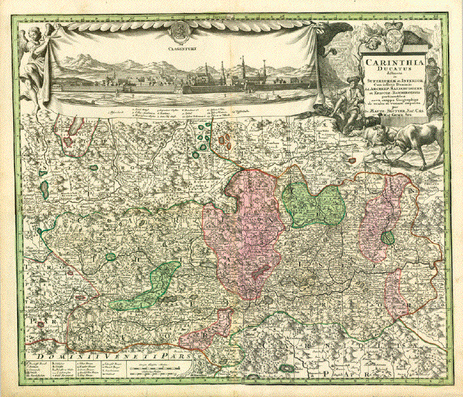
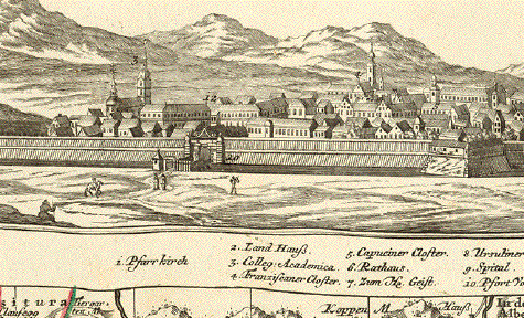
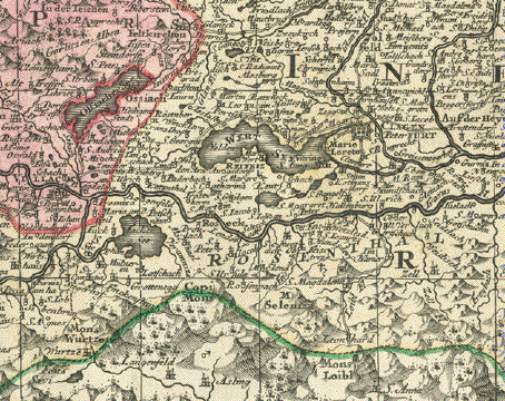
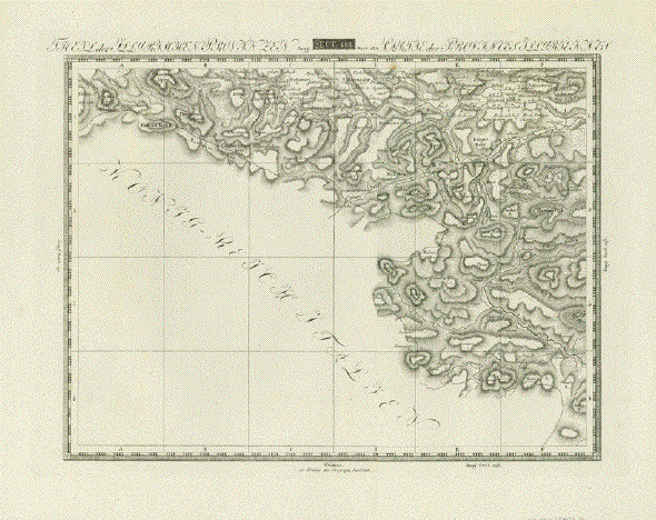
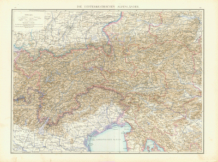
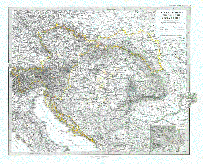
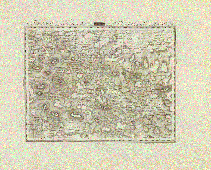
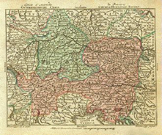
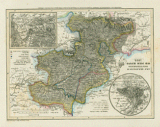
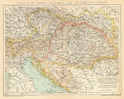
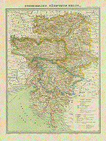
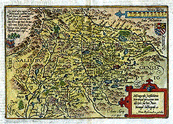
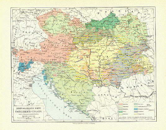
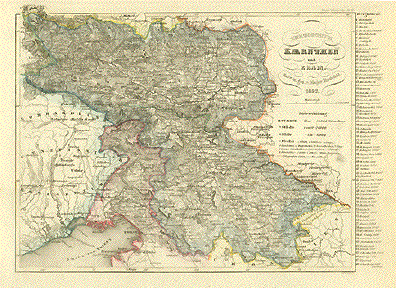
"Herzogthum Kaernthen und Krain, 1852." Steel etching from "Neuster Zeitungs Atlas. Alter und Neuer Erdkunde" by J. Meyer, ca 1855. Original outline coloring.

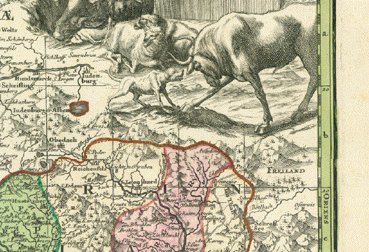
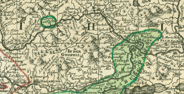
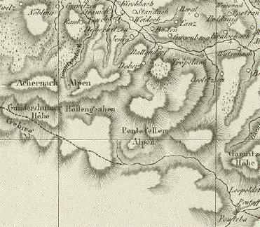
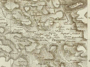
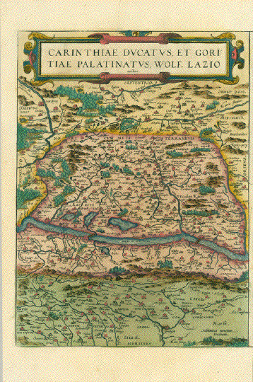
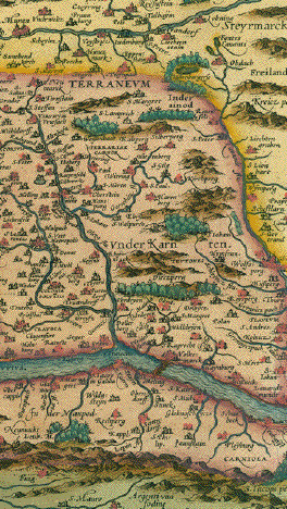
In the upper left of this detailed map is Lienz and the Pasterner Kogel. In the upper right is Obdach, St. Leonard and Reichenfels. In the center of the map is Radmansdorf and Goriach. In the lower left is the Bay of Triest with Caorle and Pirano. In the lower right is Altenmarkt and Karlstadt.

Some very minor spots in margins. Condition is otherwise Almost Very Good.

18.7 x 24.7 cm (7.3 x 9.7 ")

$ 90.00

Order Nr. AUSTRIA1016


"Nova Totius Germaniae Descriptio". Copper etching by Peter Bertius (1565-1629) for Philipp Cluver Philipp (1580 - 1623) , an early author of historic maps. His works were published long beyond his lifespan. The This map comes from a pocket size atlas (duodez): Philippi Cluverii. Introductionis in Universam Geographiam tam veterem quam novam Libri. Amsterdam, 1661. Originally colored.Centerfold. Size: ca.12 x 12,5 cm (ca.4.72 x 4.92"). Narrow margins all around, especially on right side. General toning. Minimal foxing.

This map of Central Europe focuses on Germany and the surrounding countries. The yellow - colored river to the left is the Rhine in its entire course. This map reaches far to the east with Koeningsberg in the northeast and as far south as Croatia.

$ 200.00

Order Nr. DEUTSCHLAND1182


Ansichten von Österreich-Views of Austria

Alte Trachten von Österreich - Old Costumes of Austria

Maps of the World

Ordering and payment.

E-mail:philographikon@t-online.de

Terms of sale - Lieferbedingungen

Return to Home Page