Antique Maps of Belgium
A selection of historical maps of Belgium. Each map is illustrated and described.
If you are looking for a special map, please contact us.
Antique Maps of Belgium
A selection of historical maps of Belgium. Each map is illustrated and described.
If you are looking for a special map, please contact us.
Sale! Discount!
30% Discount on All maps with a BELGIUMMAP number on this page!
WE ACCEPT REASONABLE OFFERS!
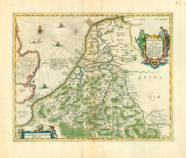
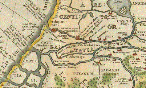
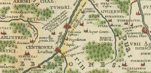
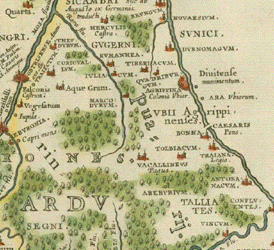
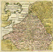
"Belgii Veteris Typus ex Conatibus Geographicis Abrahami OrteliiÉ"
Copper etching by Peter Kaerius. Hand-colored.
The title might suggest that this map was part of "Theatrum Orbis Terrarum" by Abraham Ortelius. But this is not the case. This map was produced for Ortelius but not used in his atlas.
Instead it was published by Johannes Jansson (1588-1664)
Pubiished in his "Accuratissima Orbis Antiqui Delineatio" (Atlas with historic maps)
Amsterdam, ca. 1660
Map shows the Netherlands, Belgium and Luxembourg eastwards to the run of the Rhine river and south to Frankfurt on the Main during Roman occupation. Most place names and rivers are in Latin. An interesting flash-back into history! Two hand-colored cartouches: Title and Distances.
Condition: Nice hand coloring. Centerfold has several parallel folds. Wide margins. Verso - No text print.
Normal signs of age and use.38,5 x 48 cm ( ca. 15.2 x 18.9")
$ 400.00 minus 30% Discount = $ 280.00
Order Nr. BELGIUMMAP252381
"Ducatus Brabantiae"
Copper etching by Johann Baptist Homann (1663-1724). Published ca 1720. Original hand coloring.
In the center of the map is the region of Brabant and the town of Herentals. Right above the title cartouche is Maastricht. In the lower left is Mons. In the upper right is Ravenstein and Ratenberg. Atwerpen Brussels and Mechelin are on the map.
Map has horizontal centerfold. Left margin is narrower. Light spotting in margins. Good condition.
57.8 x 48.5 cm ( 22.8 x 19.1 ")
$ 320.00 minus 30% Discount = $ 224.00
Order Nr. HOLLANDMAP1370
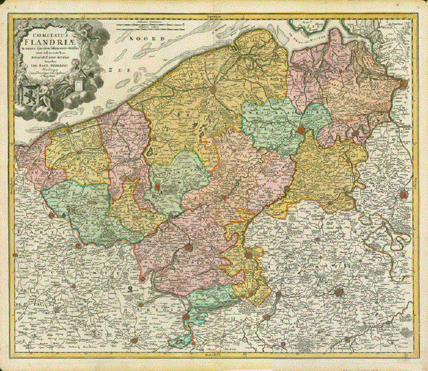
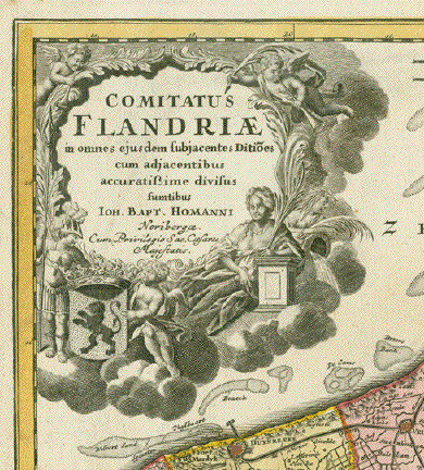
Comitatus Flandriae in omnes eijusdem subjacentes Ditio(n)es cum adjacentibus accuratissime divisus sumtibus"
Copper etching. Original hand color.
Published by Johann Baptist Homann
Nuremberg, 1723
Very nice original hand coloring. Only minimal traces of age and use.
Tiny piece of upper left margin corner is missing.48 x 57,5 cm (ca. 18.9 x 22.6")
$ 180.00 (minus 30% discount = $ 126.00)
Order Nr. BELGIUMMAP256368
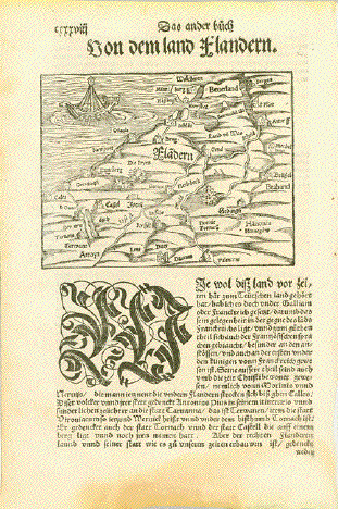
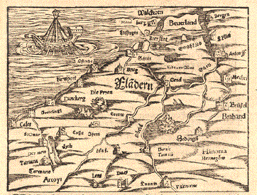
Belgium. - "Von dem land Flandern"
Woodcut. Published in "Cosmographia" by Sebastian Muenster (1488-1552)
German edition.
Basel, 1553
For the most part this map shows the Belgian Flemish province. But it reaches in parts into the Netherlands and into Northern France. Antwerp is named here "Antorff", which is the old German denomination for this city.
Very nice condition. Just a bit age-toned, lower margin some more. Reverse side of map has text print.
Map: 11,5 x 15,3 cm (ca. 4.5 x 6")
Sheet size: 31 x 19 cm (ca. 12.2 x 7.5")
$ 170.00 (Please look for discount at top of this page. Here 30%
Order Nr. BELGIUMMAP254529
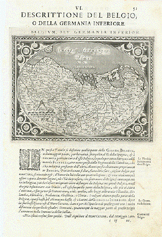
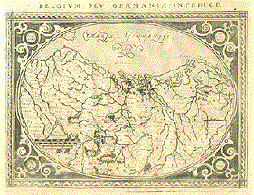
ăDescrittione del Belgio o della Germania Inferiore"
The Netherlands, Belgium, Luxembourg and parts of NW Germany in the shape of an egg.
Type of print: Copper etching
Artist: Girolamo Porro
Published in: ăGeografia cioe Descrittione Universale della Terra"
Publisher: Gio. Battista & Giorgio Galignani Fratelli
Edition: Italian edition
Editor: Giovanni Antonio Magini (1555-1617)
Text: Italian. Complete on front and reverse side
Published in: Venice
Date: 1598
Measurements:
Map size: Ca. 12,5 x 17 cm (ca. 4.9 x 6.7")
Page size: Ca. 28,5 x 19 cm (ca. 11.2 x 7.5")
Condition: Near perfect. Very minor traces of age.
Price: $ 240.00 minus 30% Discount = $ 168.00
Order Nr. BELGIUMMAP238494
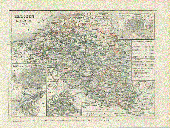
"Belgium und Luxemburg"
Detailed map published 1892.
Light, natural age zoning in margins. Vertical centerfold.
Image: 20 x 25.5 cm ( 7.8 x 10")
$ 35.00 minus 30% Discount = $ 24.50
Order Nr. BELGIUMMAP257028
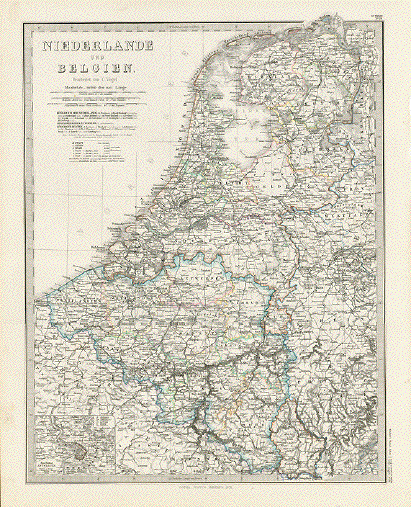
"Niederlande und Belgien"
Steel engraving after C. Vogel for Stieler. Dated 1871. Original outline coloring.
In the lowe left is a detailed inset of Antwerp and surrounding area. Map shows railroad lines that are in use and those that are planned. Map also shows the main roads of the time as well as those canals used for ships.
Map has a horizontal centerfol ad is in good condition.
41 x 32.5 cm ( 16.1 x 12.7 " )
$ 80.00 minus 30% Discount = $ 56.00
Order Nr. HOLLANDMAP238244
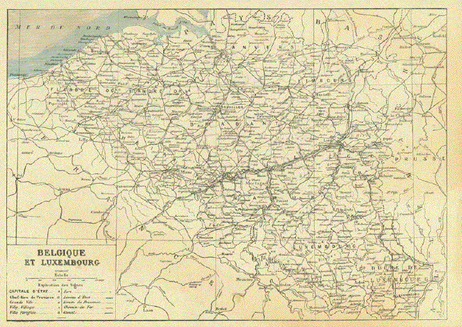
"Belgique et Luxembourg"
Detailed wood engraving map ca 1890. In the lower left is a map key
with the symbols for towns and villages as well as railroads and roads.
On the reverse side is unrelated print.Map image: 18 x 25 cm (7x 9.8")
$ 75.00 minus 30% Discount = $ 52.50
Order Nr. BELGIUMMAP255216
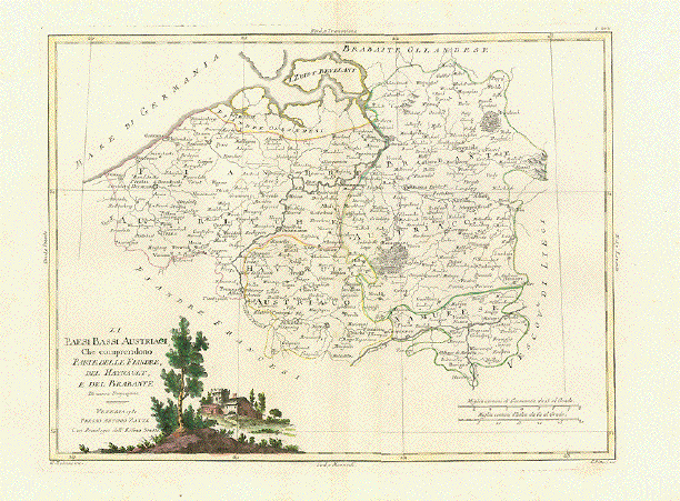
"Li Paesi Bassi Austriaci Che comprendono Parte delle Flandre, des Haynault, e del Brabante"
Map of Belgium showing the areas that were once part of Austria.
Type of print: Copper etching
Color: Original outline hand coloring. Cartouche is originally hand-colored
Author: Antonio Zatta
Published: Venice, dated 1780
Condition: Very good. Clean. Wide margins
31,2 x 41 cm (ca. 12.3 x 16.1")
$ 120.00 minus 30% Discount = $ 84.00
Order Nr. BELGIUMMAP239916
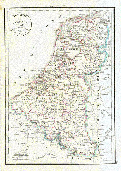
"Royaume des Pays - Bas Divise en ses 18 Provinces"
Copper engraving by F. Delamarche. Published 1832. Original hand outline coloring.
Horizontal centerfold. Spot in upper left corner - otherwise clean and in good condition.
41 x 29 cm ( 16.1 x 11.4 ")
$ 85.00 minus 30% Discount = $ 59.50
Order Nr. HOLLANDMAP242651
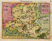
"Henault" Copper engraving by Abraham Ortelius, 1600. Hand coloring. Verso: text in French plus some fine original handwriting.
An attractive little map of the region of Conde, Ath, Halle, Cambrai amd Mons. In the upper left is the region of Flanders.
Light smudging in margins.
8 x 10.5 cm ( 3.1 x 4.1 ")
$ 115.00 minus 30% Discount = $ 80.50
Order Nr. BELGIUMMAP1083
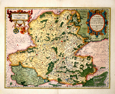
ăNobilis Hannoniae Comitatus Descriptio". Copper etching by Baptist Doetecom after drawing by Iacobo Surhonio Montano. Published in: ăTheatrum Orbis Terrarum" by Abraham Ortelius. Antwerp, 1584. Very pleasant modern hand-coloring.
Attractive map with forests, lakes, rivers and towns especially emphasized. Verso: text in French.
Lower left margin corner (about 1/2 square inch). Lower margin in center: repaired tears near vertical centerfold.
37.5 x 48.5 cm (14.8 x 19.1").
$ 380.00 minus 30% Discount = $ 266.00
Order Nr.:BELGIUMMAP1081
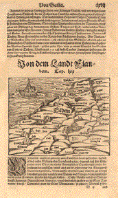
"Von dem Landt Flandern" Woodcut ca 1600. Text in Old German.
This very old map of Flanders has some very interesting historical names. Notice the historical vessel in the sea. Almost in the center of the map is Ghent. On the right side is Brussels and Brabant in southern Holland. The fascination of such maps is that they are partially inaccurate by modern standerds. On the backside is a small woodcut showing Dagobert proclaiming Christian beliefs.
The are a few scattered spots in margins. On the right margin are stains.
Page size: 34 x 21 cm ( 13,3 x 8.2 ")
Map image: 11.5 x 14.8 cm ( 4.5 x 5.8 ")$ 220.00
Order Nr. BELGIUMMAP1078
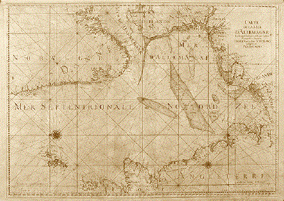
ăCarte de la Mer d'Allemagne Contenant les Bancs Isles et Costes Comprises depuis Bergen et les Isles Schetland jusques au Pas de Calais". Copper etching by Henri van Loon. Published by ăDepot de la Marine". Paris 1693
This is an extra large sea chart of the North Sea shows the coast lines of Norway from Bergen south to the Skagerrak, of the west coast of Denmark, the North Sea coast of Germany, Holland, Belgium, northern France as well as the east coast of England, Scotland plus all the islands along those coastlines , North, East and West Frisia. Quite detailed: the Orkney and Shetland Islands.
Map has general rather heavy age toning giving it patina. Upper margin has bee widened. Centerfold has been reenforced. Some worm holes along centerfold have been covered up. There are still some small worm holes left. But they are not disturbing.
61 x 86 cm (24 x 33.9")
$ 1250.00 minus 30% Discount = $ 875.00
Order Nr. BRITISHISLES MAP 1155
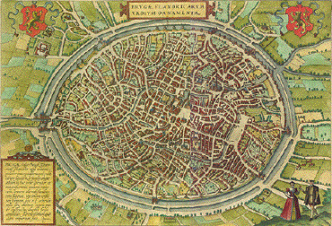
" Brugæ Flandricarum Urbium Ornamenta". Copper etching by Georg Braun and Franz Hogenberg ( 1535-1590) for "Civitis Orbis Terrarum". Fine, recent hand coloring.Um 1580.
A very decorative bird's-eye view of Bruges as it was in the 16th Century! Notice the city wall with moat surrounding the city and the fields and farmhoses in the countryside. The title is flanked by the coats of arms in the upper part of the map. A legend in the lower left gives information about Bruges. Verso: Text on one side in French about Bruges.
The margins show some spotting and creasing. Along the center fold is light spotting and rubbing. Centerfold has a small repaired tear and reinforcement. In the bottom margin near the centerfold are three small, repaired tears not affecting image. Overall condition is Better than Good.
31.2 x 46.6 cm ( 12.3 x 18.3 ")
Order Nr. BELGIUMMAP0211SOLD
|
"Die Niederlande und Belgium" Lithograph by E. Serth after T. Bromme ca 1860. Original hand coloring. Map shows Belgium, Holland and Luxembourg and parts of the surrounding countries. In the lower left corner is Amiens and Clermont in France. In the lower right corner is Ottweiler and Bexbach in Germany. In the upper right is Norden and Aurich in Germany. Map has a horizontal centerfold. Light browning on morgin edges. Repaired tear on lower right margin edge. a few light creases in right margin. 37.5 x 28.7 cm ( 14.7 x 11.2 ") $ 85.00 minus 30% Discount = $ 59.50 Order Nr. HOLLANDMAP1376 |
|
"Belgium, sev Germania Inferior" Copper engraving by Valeggio, 1718. This map in a west-oriented position shows all of present-day Belgium and parts of the surrounding countries. To the left is part of France with Paris and Reims shown. To the right is Friesland. In the lower left is Luxembourg and Westphalia is in the lower right. The four circles within the attractive design around the map give the four directions for orientation. Outside the margin around the image and on the reverse side is text in Latin. The map (on a complete page) is very clean with a somewhat weak impression. Light toning on page and frayin of right edge. Very minimal spottin in margins. Repaired hole (3mm) on far left margin. Condition of map is Almost Very Good. 12.5 x 17.3 cm (4.9 x 6.8 ") Order Nr. BELGIUM1074 SOLD |
|
"Brabantia. Tabula Castelli ad Sandflitam." Copper etching by Jan Jansson (1588-1664) in original hand coloring. Published ca 1640. Map shows the region of Brabant. The map is east oriented ( east is at the top). In the upper right is Antwerp and in the lower right is Hulst. In the upper left is information. Backside has text in Latin. The map has overall browning with some scattered spotting and smudging. There are repairs on left and right margin edges as welll as the lower corners. Vertical centerfold. Condition is Good. 37 x 49 cm ( 14.6 x 19.3 ") $ 580.00 Order Nr. HOLLANDMAP3637 |
|
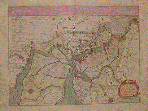
"Secunda Pars Brabantiae cuius urbs primaria Bruxellae.......". Copper etching by Michaele Florentio a Lagren for Jan Jansson (1588-1664). Published in 1647. Modern hand coloring. This map is west oriented (west is at the top). Right in the center of this map is Brussels. In the upper right is the Schelde River and Dendermonde. In the lower right is Mechlin right above the milelage chart. In the lower left is the region of Namur with the town Gemblours. Louvan is at the bottom of the map. To the right of the title is Braine-le-Comte. Map image is very clean. There is some dark spotting on the right side of lower margin. On the margin edges are a few tiny repaired tears. In the upper left corner is a small gray rectagular spot visible that shows through from the repaired tear on the reverse side. 41.2 x 51.2 cm (16.2 x 20.1 ") $ 640.00 minus 30% Discount = $448.00 Order Nr. BELGIUMMAP1368 |
|
No Title. Copper etching by Jodicus Hondius from the French edition of the atlas. Published in 1632. Original hand coloring. In the center of the map is the region of Brabant. In the upper right is Borken in Germany and in the lower right Blankenheim in Germany. In the lower left is Flanders. On the backside is text (in French) about Brabant. Map has repairs on centerfold in upper and lower margins. Margin edges are somewhat frayed. Scattered spotting in margins. Light crease in lower margin reaching slightly in image. General condition is just Good. 34.5 x 46.3 cm ( 13.5 x 18.2 ") $ 330.00 Order Nr. HOLLANDMAP1369 |
|
"Belgium und Luxemburg 1855" Steel engraving map published
by the Bibliographischen Instituts zu Hildburghausen,
1855. Hardly visiible vertical centerfold. Minor signs of age and use in margins. Image: 18.5 x 24.5 cm ( 7.2x9.6") $ 90.00 minus 30% Discount = $ 63.00 Order Nr. BELGIUM254506 |
|
|
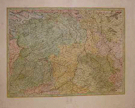
"Germaniae Cisrhennae ut inter I. Caesaris et Trajani Imperia suit, Scaldis item Mosae ac Rheni ostiorum Antiqua descriptio". Copper etching by Peter Bertius (1565-1629) for Philipp Cluver Philipp (1580 - 1623) , an early author of historic maps. His works were published long beyond his lifespan. The This map comes from a pocket size atlas (duodez): Philippi Cluverii. Introductionis in Universam Geographiam tam veterem quam novam Libri. Amsterdam, 1661. Originally colored.Centerfold. Size: ca.12 x 12,5 cm (ca.4.72 x 4.92"). Narrow margins all around, especially on right side. General toning. Minimal foxing.
This map shows a large portion of the course of the Rhine River. In the southeast of this map the Rhine enters near Breisach in southwestern Germany. The pink area comprises the countries of Belgium, Holland, Luxemburg, part of Germany and northern France. The yellow area of the northeast is part of present-day Holland and Germany. Across the English Channel is part of England.
$ 120.00
Order Nr. BELGIUMMAP1185
"France Belgium and the Netherlands" Wood engraving by T.H. Johnson and Son after E.G. Ravenstein ca 1870. Printed in color.
Detailed map showing the geological formations of the area. At the bottom is a color code of the various geological formations.. In the upper right is a list of the French Departments.
Map has a horizontal fold to fit book size.
29 x 24 cm ( 11.4 x 9.4 ")
$ 65.00
Order nr. FRANCEMAP1268
Views of Belgiume-mail: philographikon@t-online.de
Terms of sale - Lieferbedingungen
© Rainer Rauhut