Take 30% off the listed price. !
We accept reasonable offers.
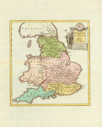
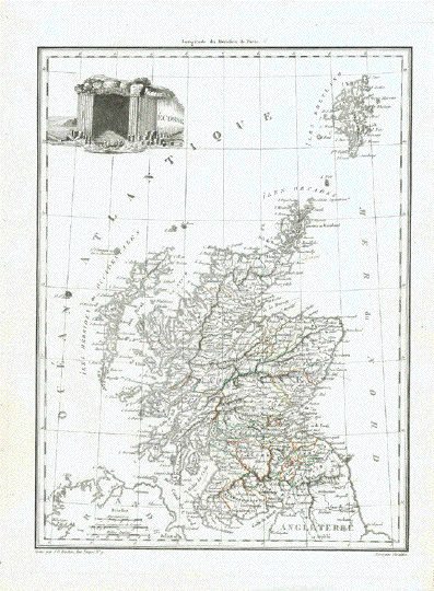
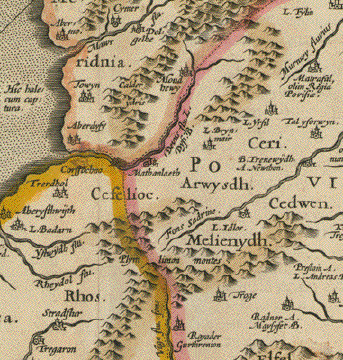
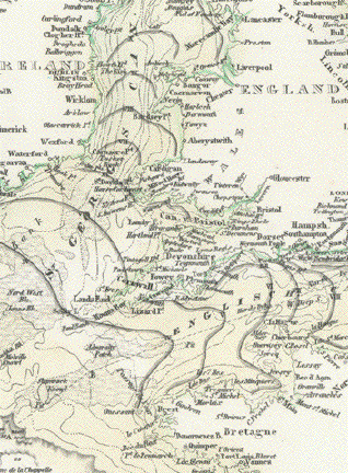
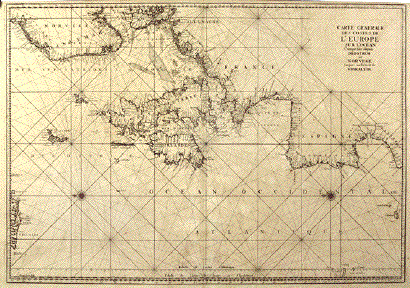
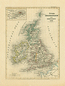
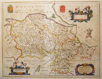
"Britanniae Romannae Tabula Antonini Imp. Interario Adaptada
a Thoma Gale Norimbergae exudit C. Weigelius"Copper engraving map published 1718 in "Descripto Orbis Antiqui" by Christoph Weigel
in Nuernberg.. The cartouche shows Roman soldiers in full uniform.
Original hand coloring.This map shows the Roman and Celtic names for many towns and natural places.
Some of the old Roman roads are shown.Map has a horizontal centerfold. Very good condition.
Map image: 32.5 x 31 cm ((12.7 x 12.2")
$ 250.00
Order Nr. BRITISHISLES253220
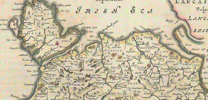
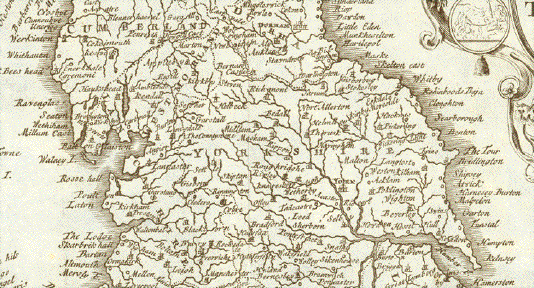
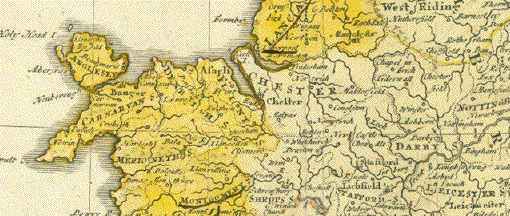
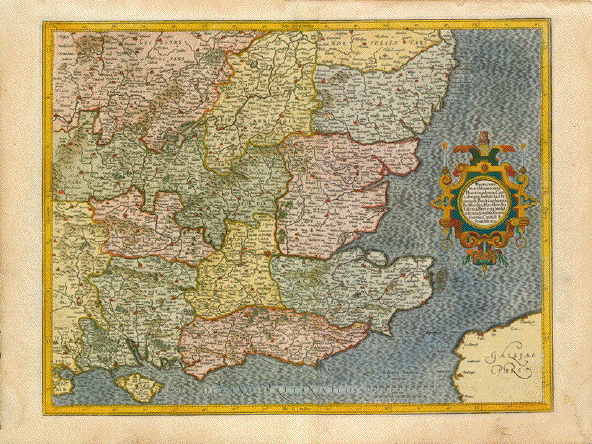
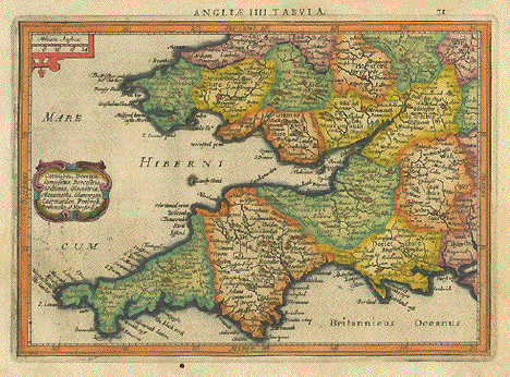
"Lancastria, Cestria, Caernarvan, Denbich, Flint, Merionidh, Montgomery, Salopia, Cardigan, Radnor, Wigornia, et Ins. Anflesey". Copper etching by Peter Kaerius (1571-1646). Amsterdam, ca 1620. Verso text in Latin. Modern hand coloring.
This map shows the reagion from Warwick in the lower right to Kirby and Lancastschire in the north. At top center is the southern part of the Isle of Mann. The easter coast of Ireland reaches from Castleton in the south to Newcastle in the north.
Map has overall age toning with a few, light, scattered spots in lower and right margins. Binding marks on left margin edge. Tiny repaired wormhole onbottom image line. Overall condition is Better than Good.
14.5 x 20 cm ( 5.7 x 7.8 ")
$ 180.00
Order Nr. BRITISHISLESMAP1130
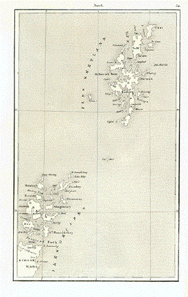
No Title
Steel engraving published 1840 showing the Shetland and Orcades Islands.
17 x 10.5 cm ( 6.6 x 4.1 ")
$ 35.00
Order Nr. BRITISHISLESMAP252097
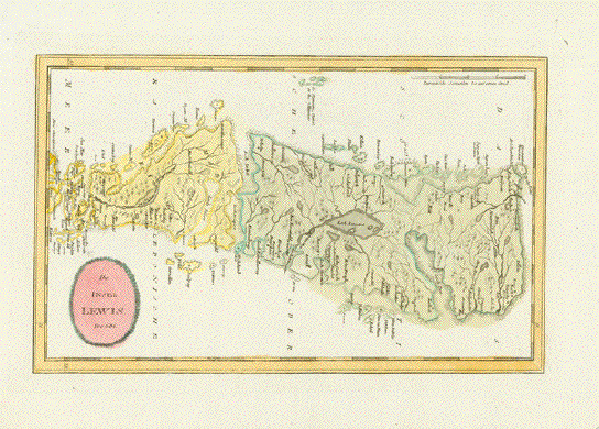
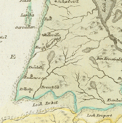
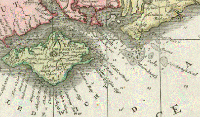
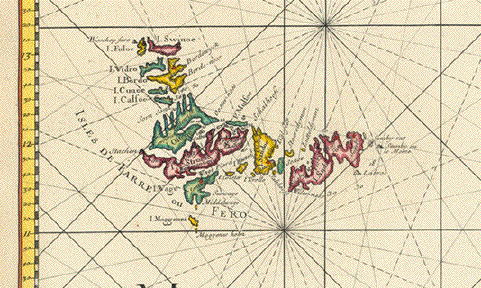
"Die Insel Lewis" Detailed part of Harris and Lewis Island (outer Hebrides)
in Scotland.
Copper etching with original hand coloring
Published by Franz Johann Joseph von Reilly (1766-1820)
In his atlas "Schauplatz der fünf Theile der Welt"
Vienna, 1789-1806
Very good condition.
20 x 32,7 cm (ca. 7.9 x 12.9")
$ 120.00
Order Nr. BRITISHISLES247845
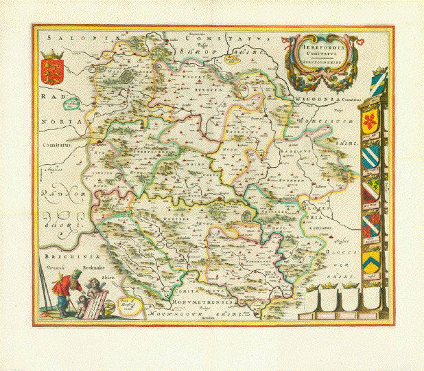
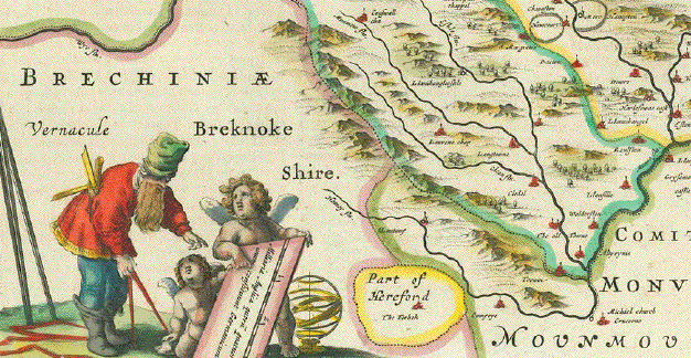
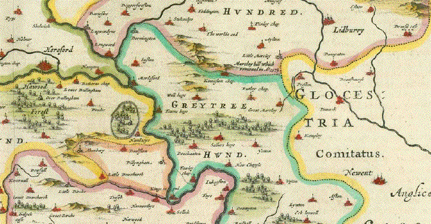
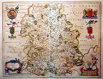
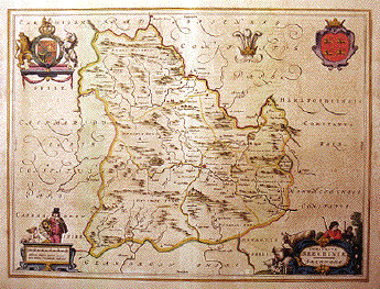
"Herfordia Comitatus, Herford-Shire". Copper etching by Wilhelm Janszoon Blaeu. Published in Amsterdam, 1645. Hand coloring.
This map, with Herford almost in the center, shows the various divisons of the time. Theornamentaion of this map is eye-catching.
Notice the Baroque cartouche in the upper right "framed" in a garland of flowers. Along the right are various
coats-of-arms, some at the bottom which were not completed. A single coat-of-arms decorates the upper left corner. In
the lower left two cherubs hold the map legend for an onlooker. Verso: Text in Spanish about Herfordshire..The map has overall light natural toning.. Minor creasing in left margin.
Condition is Very Good. Vertical centerfold.40.7 x 49.6 cm ( 16 x 19.5 ")
$ 980.00
Order Nr. BRITISHISLES MAP 1104
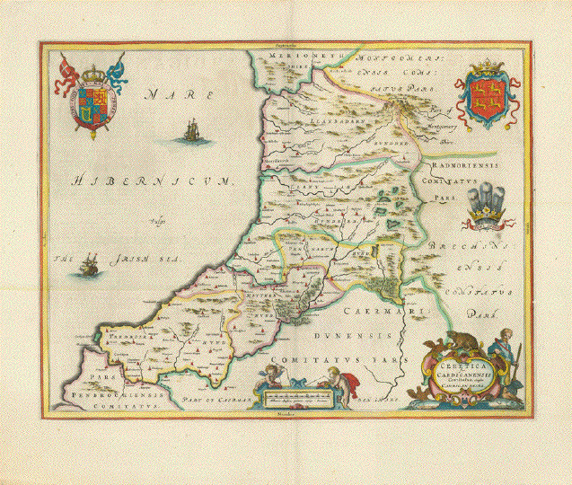
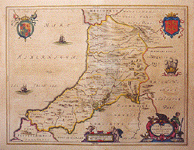
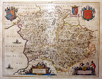
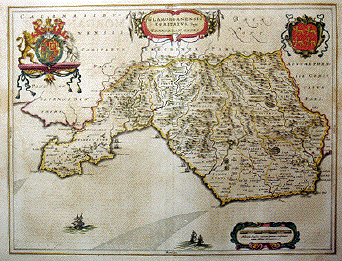
" Ceretica; sive Cardiganensis Comitatus; Anglis Cardigan Shire." Copper etching by Wilhelm Janzoon Blaeu. Amsterdam,
1645. Hand coloring.This map features CardiganShire on the west coast of Wales. This map is also decorated with various coats-of-arms and an ornamental title cartouche surrounded by a hunter and various animals. The legend at the bottom is held by two cherubs. Verso: Text in Spanish.
General light natural toning and a few spots in the margins.
Text from reverse side lightly visible.. Very minor signs of age and use.
Condition is otherwise Very Good. Vertical centerfold.Map image: 38.1 x 49.8 cm (15 x 19.6 ")
$ 980.00
Order Nr. BRITISHISLES MAP 1107
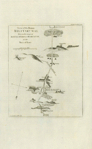
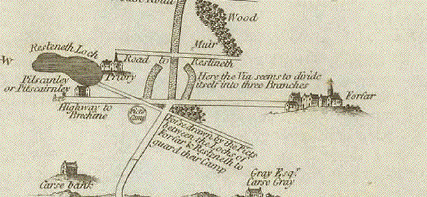
Angus and Aberdeenshire. - "View of the Roman Military Way Between the Camps of Battle Dykes & Haerfords in the Muir of Your"
Copper engraving by Jean Jamieson
Published in �Britannia or, a Chorographical Description of the Flourishing Kingdoms
of England, Scotland, and Ireland, and the Islands Adjacent"By William Camden (1551-1623)
Published by John Stockdale (1749-1814)
London, 1806
(Print is dated 1785, but it was published only in 1806)
Print has small repaired tear in right margin. Creasing in lower margin.22,2 x 17,8 cm (ca. 8.7 x 7")
$ 60.00 (Please see discount at top of this page. Here 40% = $ 36.00)
Order Nr. BRITISHISLES254626
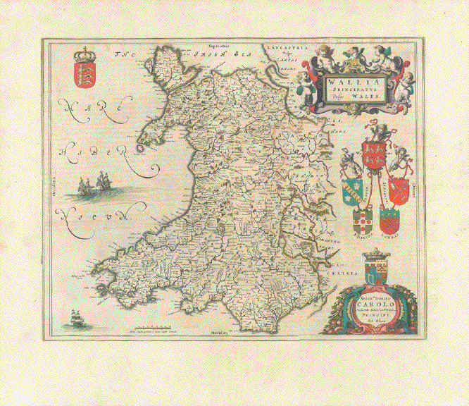
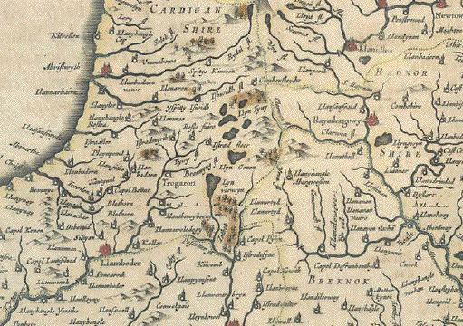
�Wallia Principatus vulgo Wales". Copper etching by Wilhelm Janzoon Blaeu. Amsterdam, 1645. Original hand coloring.
A very attractive map of Wales with Rayadergowy in the center.
Light natural age toning. Very wide margins. Vertical centerfold has been flattened.
Mounted verso on the finest of China paper to protect the wonderful original hand coloring.
The Latin text on the reverse side is lighter in tone due to the thin China paper that covers it.38 x 50 cm (15 x 19.7").
$ 980.00
Order Nr. BRITISHISLES MAP1158
"Iles Britaniques"
Wood engraving map ca 1890. Anonymous. On the reverse side
is unrelated text. In the upper left is an inset of the Shetland Islands.
In the upper right is a map key to monuments, railroad, canal, etc.Image: 25 x 19 cm ( 9.8 x 7.4")
$ 45.00
Order Nr. BRITSHISLES255201
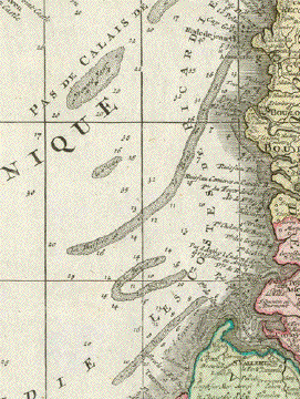
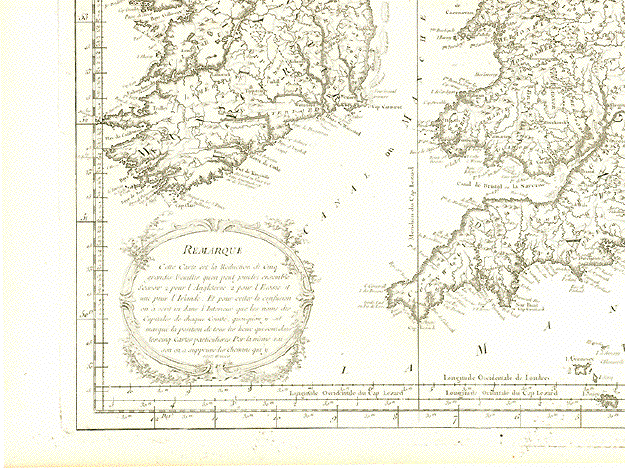
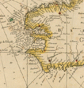
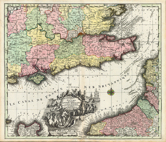
"La Plus Grande Partie de la Manche, qui contient Les Cótes d'Angleterre et celles de France les bords Maritimes de Picardie".
Copper engraving map by Matthaeus Seutter (1678-1756), ca 1720.
Original hand coloring.In the upper center of this splendid map is London. The map shows much of the
southeast coast of England on the English Channel. In the southwest is the Ise of Wight.A very decorative cartouhe is above and to the left of the coast of Normandy.
Off the coasts are the depths of the Channel as well as the banks and ports for navigation.The map has some staining in the upper area and lower right margin. Vertical centerfold.
The map is otherwise in good condition with only minor signs of age and use.
Map image: 49 x 57 cm ( 19.2 x 22.4 ")
$ 640.00
Order Nr. BRITISHISLES252332
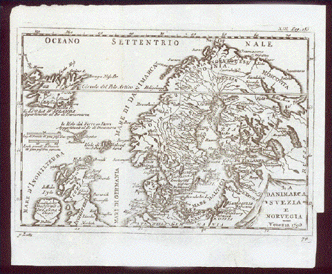
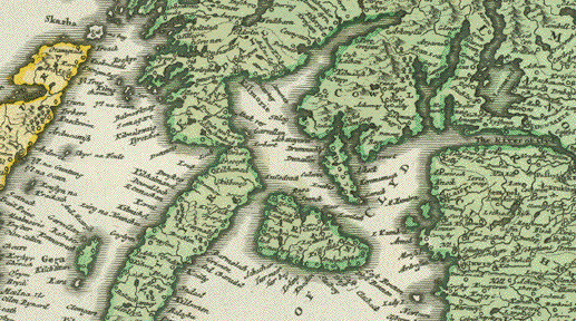
"La Danimarca, Svezia et Norvegia"
Copper engravingy by Antonio Zatta (1757-1797), Venedig, 1795
from "Atlante Novissimo, von 1775-1785"
In the upper left is Iceland and in the lower left is part
of Ireland, Scotland and England.Map has folds to fit original atlas size. Some creasing and
signs of age and use. Scanned against a black background.Map image: 14 x 20.5 cm ( 5.5 x 8")
$ 145.00
Order Nr. SCANDINAVIA255120
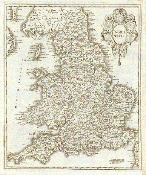
"Inghilterra".
Copper engaving map of England, Wales and southern Scotland.
Published in Band 2 of Albrizzi "Atlas novissimo del Sigr. Guglielmo de L'Isle". Venice, 1750.
Albrizz wwas a noble family in Italy.
This map is rather seldom.
Image: 38,5 x 32,4 cm 15.1 x 12.7 ")
$ 250.00
BRITISHISLES252514
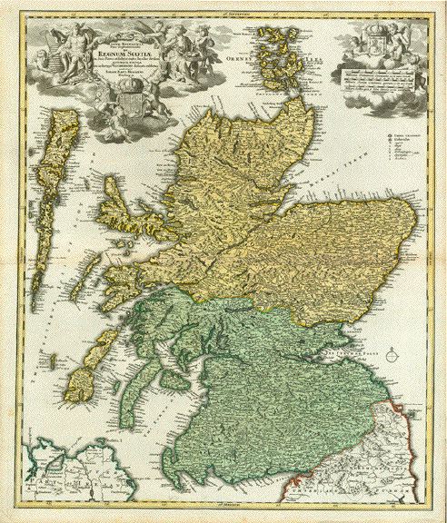
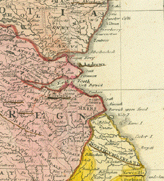
"Magna Britanniae Pars Septentrionalis qua Regnum Scotiae en Suas Partes......."
Fine copper etching by Johann Baptist Homann after Nicolas Fischer.
This map was published ca 1710 in Nueremberg.
In the upper two corners are very attractive cartouches with coats of arms.
Very early hand coloring. Strong paper
Horizontal centerfold. Reverse side is not printed.
In the margins is natural age toning and small signs of age and use.
Map image: 57.5 x 48 cm ( 22.6 x 18.8 ")
Order Nr. BRITISHISLES250785SOLD
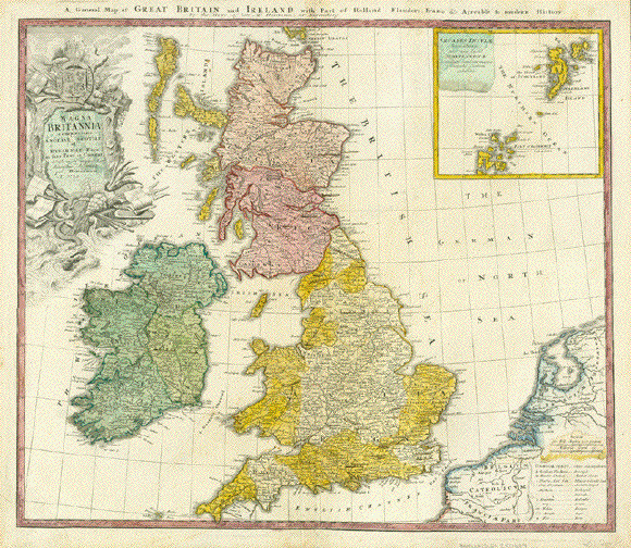
"A General Map of Great Britain and Ireland with Part of Holland, Flanders, France and agreable to modern History by the Heirs of the late Mr. Homann at Nuremberg"
Copper engraving map published 1720. Original hand coloring.
Map has a very decorative title cartouche showing the English coat-of-arms, a serpent and a sea monster. In the upper right is an inset of the Orkney Islands.
This map is very detailed with mainly English text.
"Copper engraving. Vertical centerfold .Some light spotting in upper margin,
On the reverse side are repairs on the upper and lower vertical fold. See images below.
Map image: 48 x 56 cm ( 18.8 x 22 ")"
$ 470.00
Order Nr. BRITISHISLESMAP250684
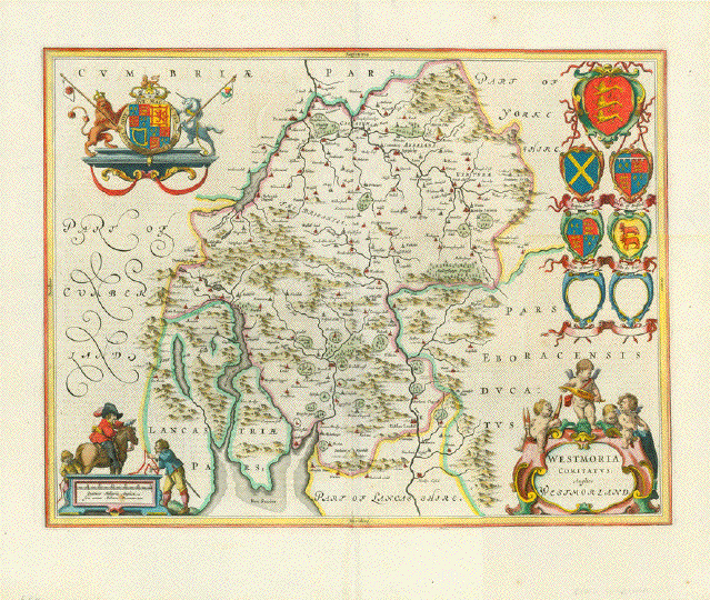
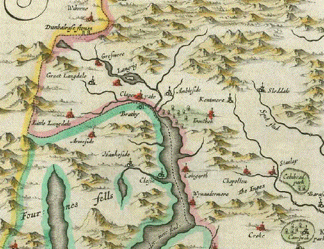
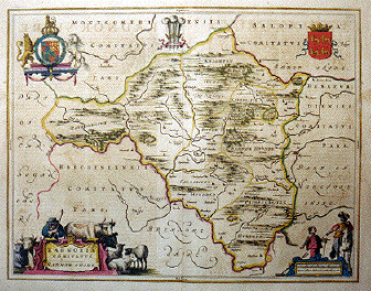
" Westmoria Comitatus ". Copper etching by Wilhelm Janzoon Blaeu. Amsterdam, 1645. Hand coloring.
Westmorland in Cumberland is the theme of this map. This map has many decorative features like the coats-of
arms and a Baroque title cartouche. In the upper left is the coat-of-arms of the British Royal Family. Verso: Text in Spanish.This map has natural light toning. Vertical centerfold. In the margin are 4 small spots.
Light crease in lower and upper areas parallel to centerfold. Thin crease on lower left side.
Otherwise the condition is Very Good.
37.8 x 49.8 cm ( 15.1 x 19.6 ")
$ 980.00
Order Nr. BRITISHISLES MAP 1106
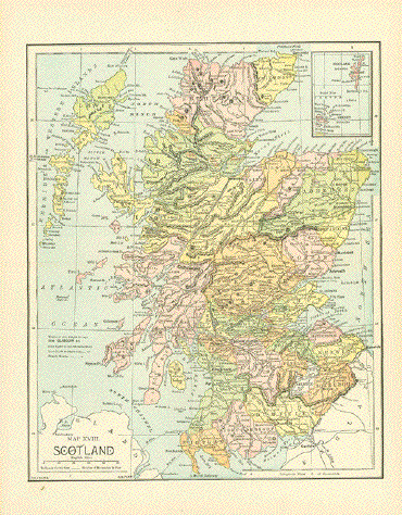
"Map XVIII Scotland"
Wood engraving map printed in color and published 1885 in New York.
In the upper right corner is a detailed inset of the Shetland and Orkney Islands.
Horizontal centerfold. Small repaired tear in right margin. Otherwise fine condition.
Image size: 28 x 22.5 cm ( 11 x 8.8")
$ 35.00
Order Nr. BRITISHISLES254505
No Title (Scotland)
In the upper left is a geological formation titled "Ecosse". In the upper right are the Shetland Islands.
In the lower left is part of Northern Ireland. In the lower right is Workington, Applebi and Durham in England.Copper engraving by J. B. Tardieu. after Giraldon published 1812. Some original outline hand coloring.#Very good condition.
Map image: 30 x 22 cm (11.8 x 8.6")
$ 95.00
Order Nr. BRITISHISLES253337
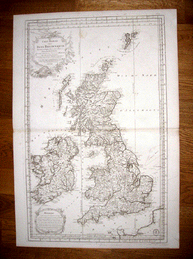
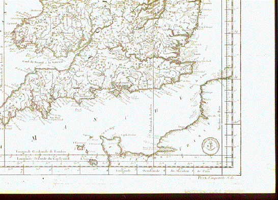
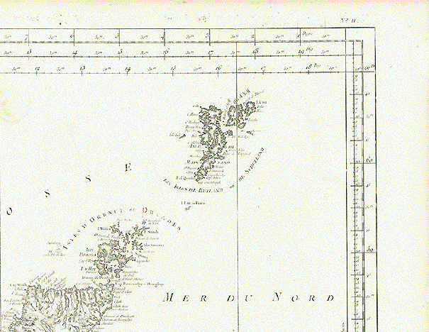
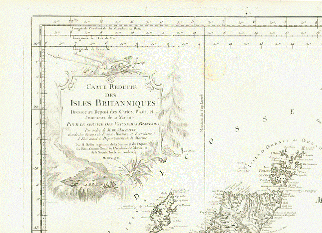
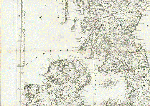
"Carte Réduite des Isles Brttanniques Dressé au Dépost des Cartes, Plans et Journaux de la Marine Pour le Service des Vaisseaux Français..."
Copper engraving by Jacques-Nicolas Bellen (1703-1772)
London, 1757
From an atlas of the French Marines.
The map is in very good condition. Strong impression. Horizontal centerfold.
Small crease northwest of Ireland not on the land of Ireland.
On the reverse side is a round stamp that is not readable. It is lightly visible on the front side upper center.
86.5 x 54.8 cm ( 34 x 21.5 ")
$ 860.00
Order Nr. BRITISHISLESMAP249554
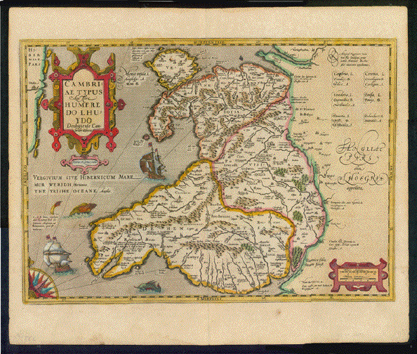
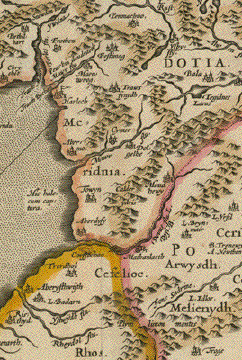
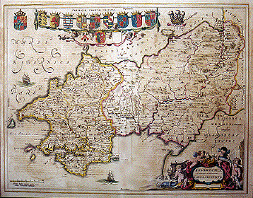
" Cambriae typus". Copper etching by Peter Kaerius after Humphrey Lloyd (1527-1568). Edited by Jodocus Hondius, 1603.
Original coloring.This very decorative map of Wales shows the many towns of the time as well as topographical detail. In the upper left corner is a
bit of Ireland. Notice the decorative sailing vessels and two sea monsters. The large Renaissance cartouche in the upper left gives
the title and name of the cartographer Humphrey Lloyd. Verso: Text in Franch.Overall toning. Two repaired tears in lower margin and a repaired tear on centerfold in lower margin. One spot (foxing) in lower margin. Some creasing on right side. Signs of age and use.
34.9 x 49.4 cm ( 13.7 x 19.4 ")
$ 780.00
Order Nr. BRITISHISLESMAP1109
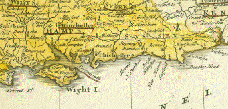
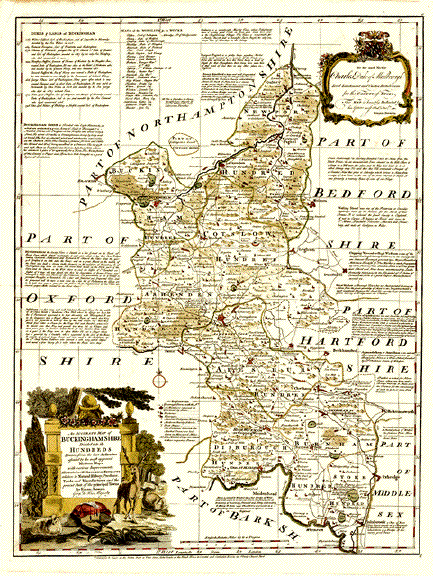
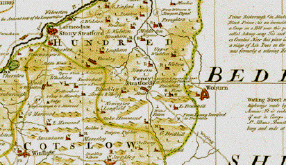
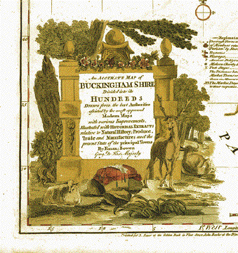
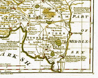
�An Accurate Map of Buckinghamshire Divided into its Hundreds Drawn from the best Authorities assisted by the most approved Modern Maps with various Improvements. Illustrated with Historical Extracts relative to Natural History, Produce, Trade and Manufactures and the present State of the principal Towns By Eman Bowen Geog(apher) to his Majesty"
Copper etching by Eman Bowen (1694-1767). Original hand coloring.
Published in the Large English Atlas or a new set of maps of all the counties of England and Wales.
London, not dated. But published 1747
Very detailed map of the County of Buckinghamshire with historical and other important detailed notessurrounding the actual map. Nice, decorative title cartouche with a stag, a cow, a sheep and a cushion for lace making (tattling). Asecond cartouche: Dedication �To the most Noble Charles of Marlborough..." by Eman Bowen. With coat of arms motto: �Dieu defend le Droit"
Map is clean and in very good condition. Upper left margin corner has crease and tear outside image and a piece of margin paper missing. Overall pleasant age toning.
$ 680.00
Order Nr. BRITISHISLESMAP248780
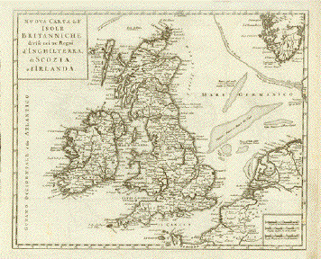
Nuova Carta dell' Isole Britanniche divise nei tre Regni d'Inghlaterra, di Scozia, e d'Irlanda (Great Britain and Ireland) Copper etching from Thomas Salmon: Modern History. 1743
A specialty of this map that it indicates larger sandbanks in the North Sea
Map has several horizontal and vertical folds to make it fit original book size. Right margin has been widened and partially added. Small repairs where map was hitched to the binding of book
27 x 33.5 cm (10.6 x 13.2")
$ 220.00
Order Nr. BRITISHISLESMAP11630
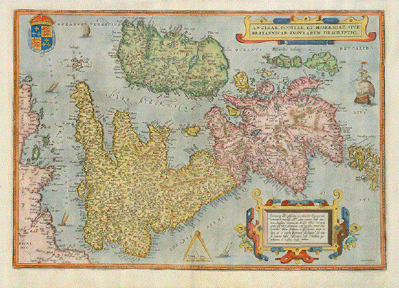
"Angliae, Scotiae, et Hiberniae, sive Britannicar: Insularum Descriptio"
Hand-colored copper etching from �Theatrum Orbis Terrarum"
By Abraham Ortelius
Published in Antwerp. From the very rare First Edition 1570
Reverse side Text in Latin
Atlas page nr. 6
This west-oriented map of the British Islands is much sought and gladly acquired by serious collectors - especially when published in the very rare firs edition.
Adorned with two Renaissance cartouches and with such decorative embellishments as the royal coat of arms (�Hony soyt qui mal y pense" - sic!), sailships and a mileage compass, this map fulfills every expectation of a decorative masterpiece.
Margins have been amended on left, right and top. Some minor repairs along centerfold. One small repared tear in lower margin. Otherwise very good.
34,3 x 49,7 cm (ca. 13.5 x 19.5")
Order Nr. BRITISHISLES237395 SOLD
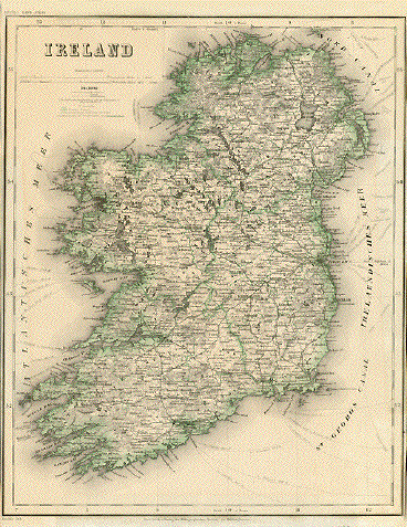
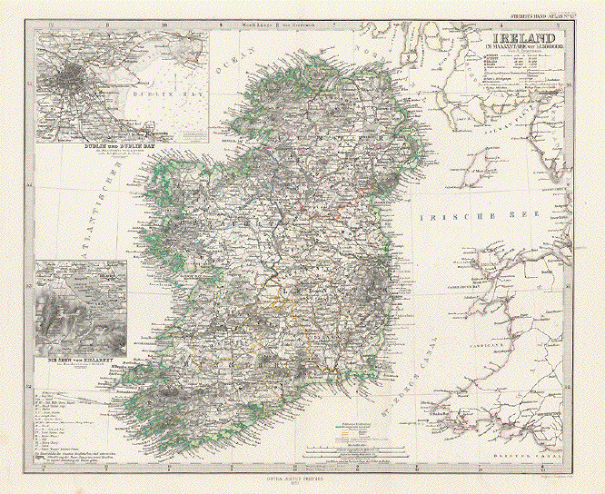
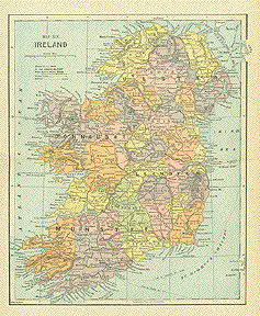
"Ireland"
Steel engraving for Meyer´s Hand Atlas, 1868. Original outline coloring.
Detailed map showing the railway lines of the time as well as the routes of the steamships. The counties are outlined in green.
Map has no side margins. At the top and bottom are dark areas caused by earlier framing. Overall light age toning.
37 x 29.5 cm ( 14.5 x 11.6 ")
Order Nr. BRITISHISLESMAP237692SOLD
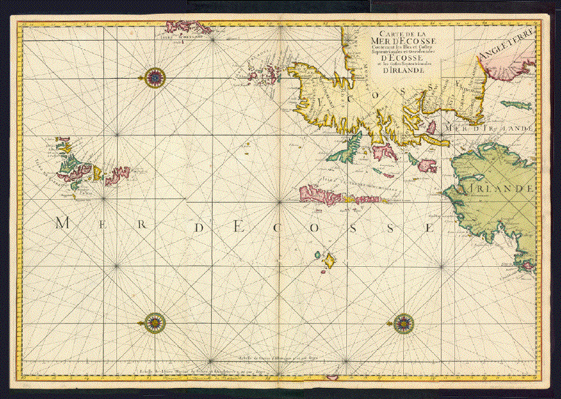
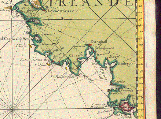
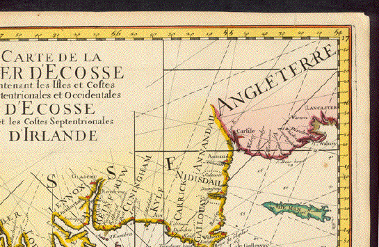
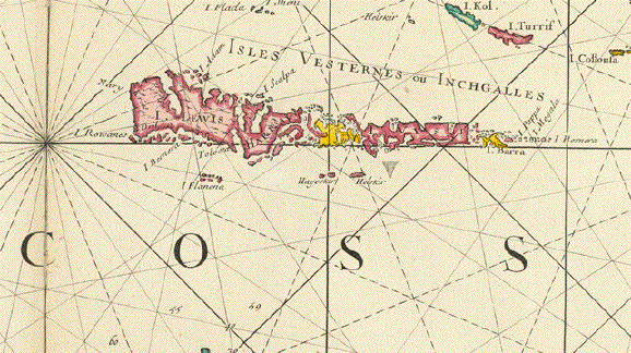
�Carte de la Mer d'Ecosse Contenant les Isles et Costes Septentrionales D'Ecosse et les Costes Septentrionales D'Irlande"
Copper etching in original hand coloring. Portolan map of Western Scottland, Northern Ireland, the isles of Orkney, Hebridean, Faeroer and Western Shetland, Kilda
Very attrractive sea chart by Alexis Hubert Jaillot (1632-1712). Originally published in 1693.
This map does no mention any credits to author or publisher. This fact and the watermark indicate, that the map was printed from the original copper plate, but published in Paris in 1753
Condition is near Very Good. Centerfold has been partially doubled. Some repairs on centerfold. Tiny repairs on margin edge.
Absolutely beautiful hand coloring with three decorative windroses with diverse design. Minor traces of age and use.
60.5 x 86.5 cm (ca. 23.8 x 34")
$ 1800.00
Order Nr.BRITISHISLES238438
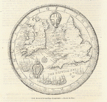
"1651 Scan de la republique d'Angleterre"
Circle text: "The Great Seale of England"
Wood engraving by Adrien Feart after the old original in 1651. Published 1883. Below the image and on
the reverse side of the page is text about Great Britain.Diameter of map: 14 cm (5.5 " )
$ 50.00
Order Nr. ENGLAND245068
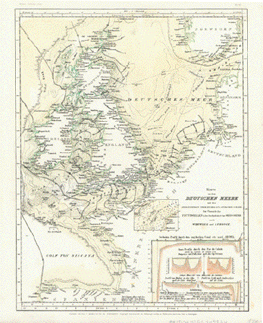
"Karte von dem Deutschen Meere und den angrenzenden Teilen des Atlantischen Ozeans. Zur Übersicht der Flutwellen und der Beschaffenheit des Seebodens nach Whewell und Lubbock"
Chart of the North Sea and its ajacent parts of the Atlantic Ocean. Overview of flood waves (tsunamis) and the profiles of the bottoms of the sea according to Whewell and Lubbock.
Steel engraving with original hand coloring.
Published by Meyer. Hildburghausen, ca. 1850
Very good condition
27,6 x 21,5 cm (ca. 10.9 x 8.5")
$ 80.00
Order Nr.BRITISHISLES247844
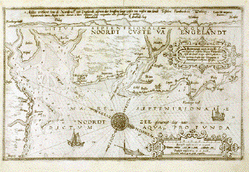
�Beschryvinghe vande Zee Custen van Engelandt tusschen Blacgney en Scharenburch Alsoe das Landt en zyn wesen en gedaente is".
Copper etching byJohannes Doetecum. Published by Lucas Janzoon Waghenaer in his famous atlas �Spieghel der Zeevaerdt" (Mariner's Mirror). Amsterdam, 1585. Verso: Text in Dutch.
Map shows part of Yorkshiore coastline near Kingston upon Hull, with the famous resorts Scarborough, Filey, Flamborough Head, Robin Hood's Bay, etc. Two Renaissence cartouches: title and mileage. One of the earliest sea charts ever. Two Renaissance cartouches, a wind rose, sailships add to the very charming appearance of this very rare map. Thick velim indicates first edition.
General age toning. Ample margins somewhat spotty and frayed along edges. Otherwise in very good condition considering age of map.
32.5 x 51 cm (13.5 x 20").
Order Nr. BRITISHISLES MAP 1157 SOLD
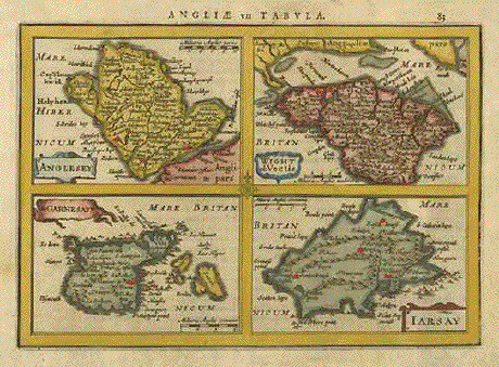
"Angliae vii Tabvla". Copper etching by Peter Kaerius (1571-1646). Amsterdam, ca 1620. Verso text in Latin. Modern hand coloring.
In the upper right of this map is the Isle of Wight with a bit of southern England above. It is titled: "Wight,Vectis olim". To the
south is the Island of Jersey, titled: "Iarsay". In the lower left is the Island of Gurnsey with small Channel Islands titled: "Garnesay".
In the upper left is Anglesey, with the title: "Anglesey". All show topography such as rivers and mountains in detail. Verso: Text in Latin.Map has overall age toning. Binding marks on left margin edge. Tiny repaired tear on lower margin edge and tiny repaired wormhole in lower margin. Overall condition is Better than Good.
13.6 x 19.5 cm ( 5.3 x 7.6 ")
Order Nr. BRITISHISLES MAP 1131 SOLD
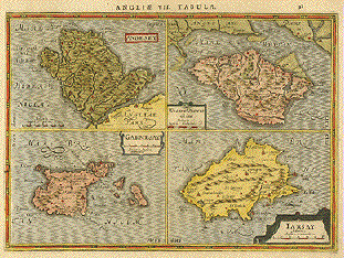
" Angliæ VII Tabula". Copper etching by Mercator at Kaeriusin attractive modern coloring. 1632.
In the upper right of this map is the Isle of Wight with a bit of southern England above. It is titled: "Wight,Vectis olim". To the
south is the Island of Jersey, titled: "Iarsay". In the lower left is the Island of Gurnsey with small Channel Islands titled: "Garnesay".
In the upper left is Anglesey, with the title: "Anglesey". All show topography such as rivers and mountains in detail. Verso: Text in Latin.Light toning and a small crease in lower margin. Condition is otherwise Almost Very Good.
18.2 x 25.2 cm ( 7.2 x 9.8 ")
Order Nr. BRITISHISLES MAP 1101 SOLD
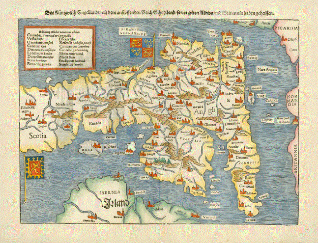
"Das Kuenigreich Engellandt mit dem anstossenden Reich Schottland so vor Zeiten Albion und Britannia haben geheissen"
Kingdom of England with neighboring Scotland
Hand-colored woodcut. Published in "Cosmographia" by Sebastian Muenster.
German edition. Basel, ca. 1550.
East-oriented map of England, the southern parts of Scotland and parts of Ulster in Northern Ireland. In the distance: The Continental coastline France.
Attractive and old woodcut map, charming because of its east orientation.
Minimal traces of age and use. Very good condition.
25 x 34 cm (ca. 9.8 x 13.4")
Order Nr. GREATBRITAIN242275 SOLD
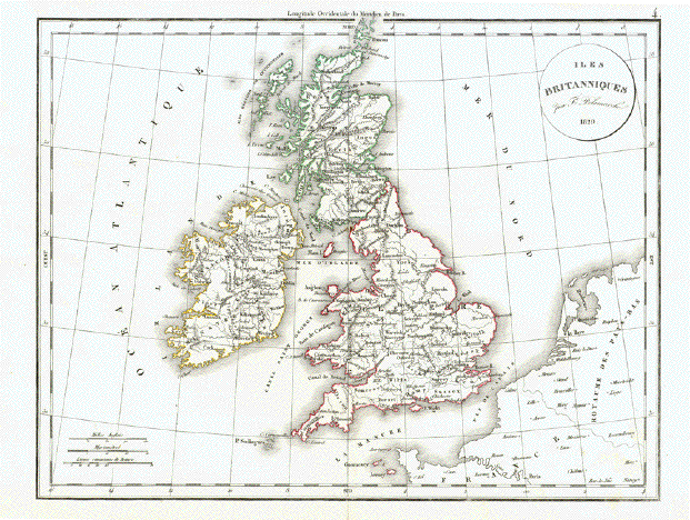
"Iles Britaniques par F. Delamarche 1829"
Copper engraving by F. Delamarche, 1829. Published in his atlas in 1832.
Original hand outline coloring. Fine, clean image.Map has a repair in lower margin on the vertical centerfold. Small repair on lower margin edge.
27.5 x 36 cm ( 10.8 x 14.1 ")
$ 35.00
Order Nr. BRITISHISLES242290
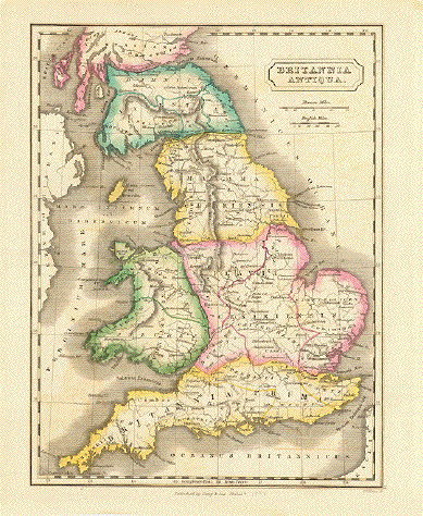
"Britannia Antiqua"
Engraved by P. E. Hamm for "The Atlas of Ancient Geography". Published in Philadelphia by Lea and Blanchard, 1844.
Original hand coloring. Horizontal centerfold to fit original abook size. Light age toning.
23 x 17 cm ( 9 x 6.6 ")
$ 90.00
Order Nr. BRITISHISLES241834
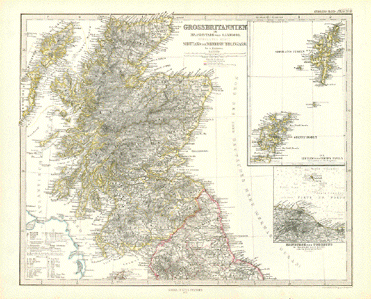
"Grossbritannien"
Steel engraving by Poppey and Jungmann after A. Petermann for Stieler. Dated 1871.
Original hand outline coloring.Very detailed map of Scotland and the northermost part of England. In the upper right is an inset of Orkney Island and Shetland Island. Below is an inset showing Edinburg and surrounding area.
Map is in good condition. Vertical centerfold.
33.2 x 40.2 cm ( 13 x 15.8 ")
$ 90.00
Order Nr. BRITISHISLESMAP238004
"Grossbritannien"
Steel engraving by Poppey and Jungmann after Ernst Debes and A. Petermann for Stieler. Dated 1871.
Original hand outline coloring.Very detailed map of southern England. In the lower left is a detailed inset of the Channel Islands of Jersey and Gurnsey.
Map is in good condition. Vertical centerfold. Small repair in lower margin on centerfold.
33.2 x 40 cm ( 13 x 15.7 ")
$ 90.00
Order Nr. BRITISHISLESMAP238005
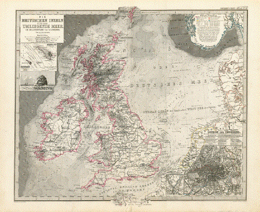
"Die Britischen Inseln und das umliegende Meer"
Steel engraving by Poppey and Stichartafter Ernst Debes and A. Petermann for Stieler. Dated 1871.
Original hand outline coloring.Very detailed map of sthe British Isles.. In the upper left is a detailed inset of Helgoland ( Germany) and below a view of Rockall. In the lower right is a detailed inset of London and the surrounding area. The very small inset shows the Cristal Palace area south of Bulwich. The depths of the sea are given as well as the well-known fishing banks of the time.
Map is in good condition. Vertical centerfold. Small Repair on lower centerfold.
34.5 x 40 cm ( 13.5 x 15.7 ")
$ 95.00
Order Nr. BRITISHISLESMAP238006
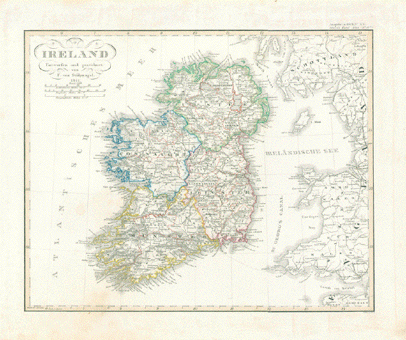
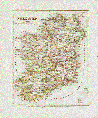
"Ireland Entworfen und gezeichnet von F. von Stuelpnagel 1841. Revid. 1848"
Engraved by C. Metzeroth for Stieler's Hand Atlas. Original outline coloring.
Light browning and spotting in margins. Minor spots in image.
28.5 x 35.5 cm ( 11.2 x 13.9 ")
$ 60.00
Order Nr. BRITISHISLESMAP242157
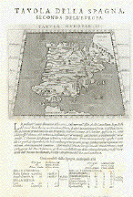
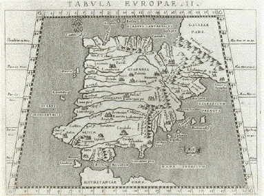
"Tavola della Spagna, Seconda dell'Europa" - Spain and Portugal (Iberian Peninsula)
Copper etching after Claudius Ptolemaeus published in �Geografia cioe Descrittione Universale della Terra" Gio. Battista & Giorgio Galignani Fratelli. Venice, 1598
First edition in Italian prepared by Giovanni Antonio Magini (1555-1617)
Clean. Only minimal traces of age and use.
Sheet size 27.5 x 19 cm (10.8 x 7.5")
Each of the maps: 13 x 17.2 cm (5.1 x 8.8")
$ 400.00
Order Nr. ESPAÑA235806
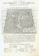
Reverse Side:
"Tavola dell'Ibernia, e dell'Albione, Prima dell'Europa" - Irelandf and Great Britain (England, Ireland and Scotland)
Copper etching after Claudius Ptolemaeus published in �Geografia cioe Descrittione Universale della Terra" Gio. Battista & Giorgio Galignani Fratelli. Venice, 1598
First edition in Italian prepared by Giovanni Antonio Magini (1555-1617)
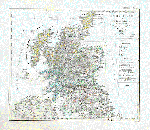
"Shotland mit der Noerdlichen Spitze von England den Shires
Northumberland, Durham Cumberland"Steel engraving by Ad. Gottschalck after F. von Stuelpnagel.
This map is the 1843 revised edition of the map first printed in 1837.Clean mp with ony very minor signs of age and use.
30 x 35 cm ( 11.8 x 13.7 ")
$ 90.00
Order Nr. BRITISHISLES240893
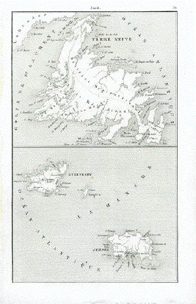
"Nord"
Steel engraving map of Newfoundland at the top and the Channel Islands
of Guernsey, Jersey and Douglas in the lower part.
Published 1840. Very good condition.Image: 17.5 x 10.5 cm ( 6.8 x 4.1")
$ 45.00
Order Nr. NORTHAMERICA255116
"Irland"
Steel engraving by Poppey & Jungmann dated 1870. Original hand outline coloring.
Very detailed map showing the political divisions of the time as well as the very early railway routes of the time. In the upper left is an inset of Dublin and the surrounding area. Below left is another inset with the lakes of Killarney.
Map image is clean and in good condition. Minor signs of age and use in lower margin. Vertical centerfold.
33.5 x 40.3 cm ( 13.1 x 15.7 ")
$ 125.00
Order Nr. BRITISHISLES238639
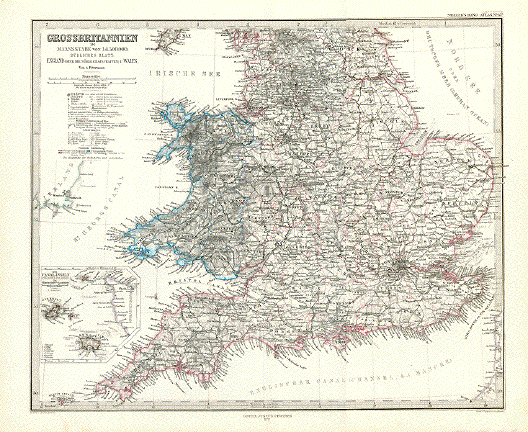
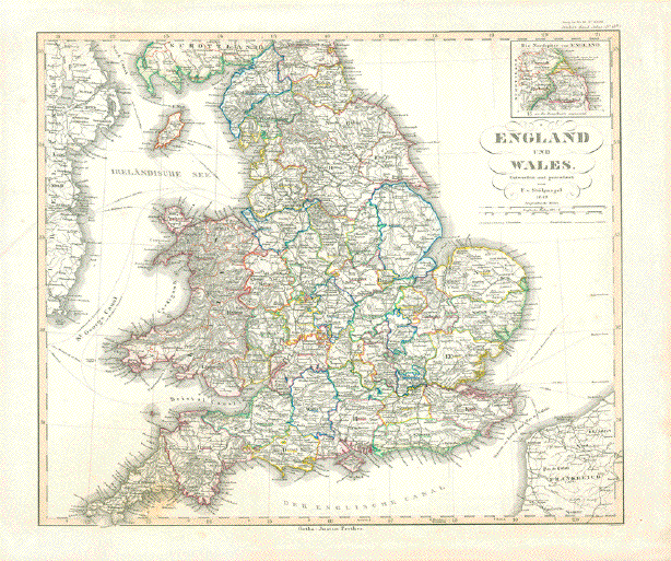
"England und Wales"
Steel engraving map with original hand outline coloring by F. v. Stuelpnagel in 1849.
The map was engraved by Metzeroth and published 1857 in Stieler's Atlas.In the upper right is an inset of the northern point of England with the city of Berwick and Roxburgh.
Map has light age toning and a few spots in margins.
32 x 37 cm ( 12.5 x 14.5 ")
$ 65.00
Order Nr. BRITISHISLES242273
No title.
Steel engraving showing the Shetland and Orkney Islands. Printed ca 1840.
17 x 10 cm ( 6.6 x 3.9 ")
$ 40.00
Order Nr. BRITISHISLES240959
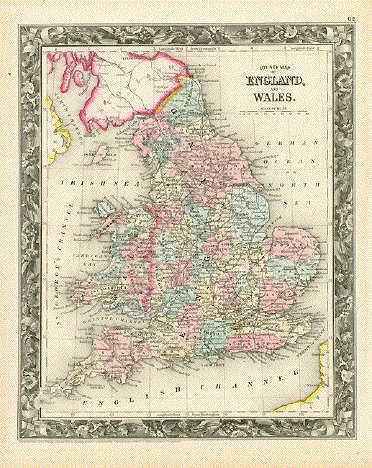
"County Map of England and Wales"
Steel engraving from "Mitchell's New General Atlas, Containing Maps Of The Various Countries Of The World, Plans Of Cities, Etc. Embraced In Forty-Seven Quarto Maps, Forming A Series Of Seventy-Six Maps And Plans, Together With Valuable Statistical Tables." Published in Philadelphia 1860. This is from the first edition of the atlas that was published until 1893. Original hand coloring.
Map has minor signs of age and use.
33.5 x 27 cm ( 13.1 x 10.6 ")
$ 90.00
Order Nr. BRITISHISLES239583
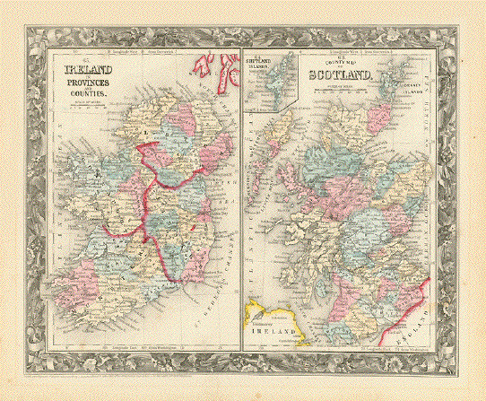
Left side: "Ireland in Provinces and Counties"
Right side: "County Map of Scotland"Steel engraving from "Mitchell's New General Atlas, Containing Maps Of The Various Countries Of The World, Plans Of Cities, Etc. Embraced In Forty-Seven Quarto Maps, Forming A Series Of Seventy-Six Maps And Plans, Together With Valuable Statistical Tables." Published in Philadelphia 1860. This is from the first edition of the atlas that was published until 1893. Original hand coloring.
Map has minor signs of age and use. Light scattered spotting in margins.
27 x 33.5 cm ( 10.6 x 13.1 ")
$ 90.00
Order Nr. BRITISHISLES239584
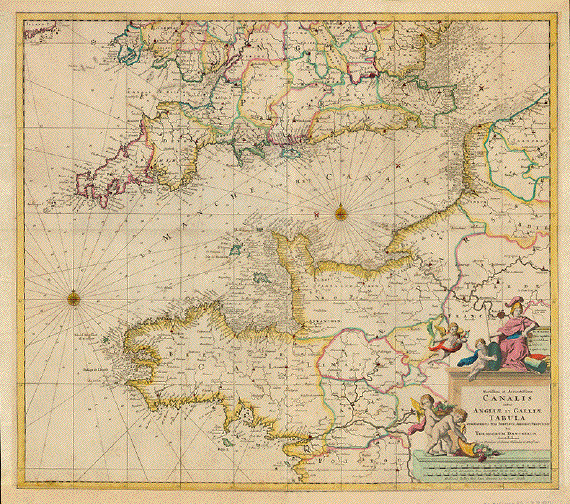
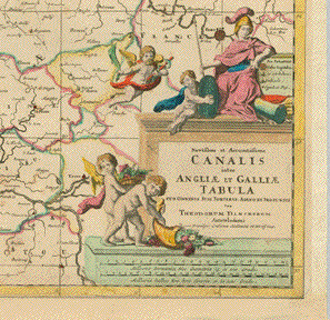
�Novissima et Accuratissima Canalis inter Angliae et Galliae Tabula cum omnibus suis Portibus Arenis et Profundis..."
Copper etching by Theodor Danckerts (1633-1727). Original hand coloring.
Published in Amsterdam, ca. 1695
Sea chart of the British Channel. Portolan showing in detail Southern coastline of Great Britain as well as coastlines of Belgium and France (Normandie and Bretagne (Brittany). Shallows and depths are marked as well as sea battles (1666 - Four Day Battle - 1690 Beachy Head - 1692 Barfleur)
Very nice original outline hand coloring. Pleasant title cartouche in original hand coloring.
Margins all around have been added. The paper used for the margins is 17th century paper.
There is a vertical crease running around Bristol to Quimperlay in the Britagne. There is some very minor creasing here and there on the map, but hardly visible and to be considered as patina on a more than 300 year map. Interesting is the portolan approach and the unusual portolan image and the quite unusual section shown, with the detailed south coast of England and the equally detailed coast and hinterland of Normandy and Britagne. What makes this map so intriguingly fascinating is the playful and very handsomely hand colored title cartouche with Francia (Gallia, later on, after the French Revolution: Marianne) and four cherubs, two of them winged, holding a rod of Asclepius, a shield, and two of them each with a cornucopia.
50,5 x 58 cm (ca. 19.9 x 22.8")
Order Nr.BRITISHISLES238177 SOLD
�Ultoniae Orientalis Pars"
Map shows Eastern part of Ulster (North Ireland)
Outstandingly originally hand-colored copper etching by Gerard Mercator (1512-1594)
Published posthumously by Mercator's son Rumold in Duisburg, 1595
Printed on very thick paper of the first edition. Verso text: Latin
Beautiful Renaissance title cartouche!
General age toning. Margins a bit spotty.
34,8 x 38 cm (ca. 13.7 x 15")
$ 800.00
Order Nr.BRITISHISLES238166
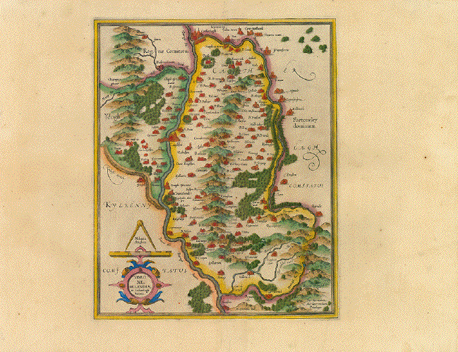
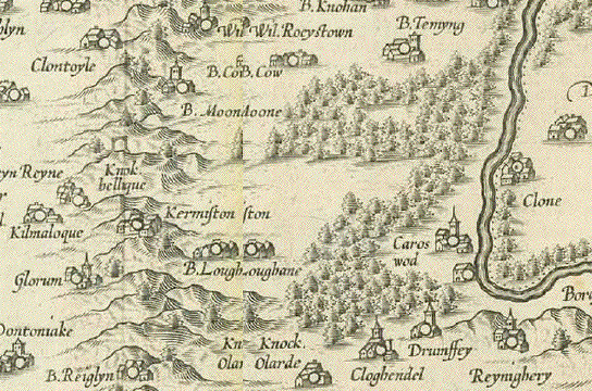
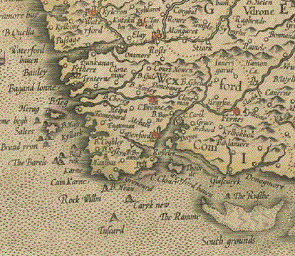
�Udrone Irlandiae in Caterlagh Baronia"
Outstandingly originally hand-colored copper etching by Gerard Mercator (1512-1594)
Map shows present day County Carlow in Leinster Province and Catherlaugh, now Carlow.
Published posthumously by Mercator's son Rumold in Duisburg, 1595
Printed on very thick paper of the first edition. Verso text: Latin
Beautiful Renaissance title cartouche!
General age toning. Very wide margins a bit spotty. Centerfold with parallel crease.
34 x 27,5 cm (ca. 13.4 x 10.8")
$ 580.00
Order Nr.BRITISHISLES238165
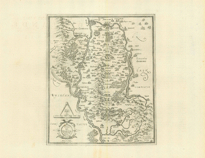
�Udrone Irlandiae in Caterlagh Baronia"
Detailed and decorative copper etching by Gerard Mercator (1512-1594)
Map shows present day County Carlow in Leinster Province and Catherlaugh, now Carlow.
Published in Amsterdam ca 1620.
Verso text: French
Very wide margins.Vertical centerfold.
Image is clean. A few minor signs of age and use in margins.Map image: 34 x 27,5 cm (ca. 13.4 x 10.8")
Page size: 44 x 56.5 cm (17,3 x 22.2")
$ 380.00
Order Nr.BRITISHISLES254583
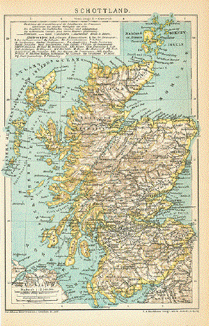
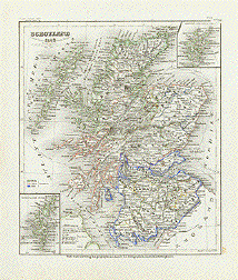
"Schottland"
Detailed map of Scotland, 1895. Left margin is narrow.
21.5 x 14.5 cm ( 8.4 x 5.7 ")
Order Nr. BRITISHISLES244494SOLD
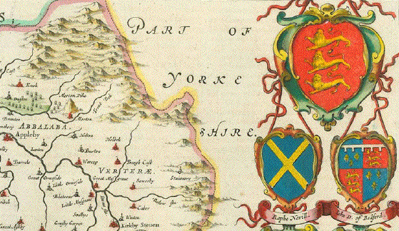
�Warwicum, Northhamptonia, Huntigdonia, Cantabrigia, Suffolcia, Oxonium, Buckinghamnia, Bedfordia, Hartfordia, Essexia, Berceria, Middelsexia, Southhatonia, Surria, Cantiu(m) & Southsexia"
Map shows South-East Great Britain. London centrally located.
Outstandingly originally hand-colored copper etching by Gerard Mercator (1512-1594)
Published posthumously by Mercator's son Rumold in Duisburg, 1595
Printed on very thick paper of the first edition. Verso text: Latin
Shows northern part of Scotland with Orkney Islands and part of the Hebridean Islands.
Beautiful Renaissance title cartouche!
Map has general age toning. Margins have some waterspots well away from image. Centerfold has been reenforced. General condition: Near Very Good.
36,7 x 47 cm (ca. 14.5 x 18.5")
$ 800.00
Order Nr. BRISISHISLES238201
�La plus grande Partie de la Manche qui contient Les Cotes d'Angleterre et celles de France les Bords Maritimes de Picardie..."
Copper etching by Matthaeus Seutter. Original hand coloring. Augsburg, ca. 1730
Map shows both sides of British Channel. Beautiful baroque title cartouche with gods Neptune and Mercator
Very strong impression. Some minor creasing. Margins spotty in parts. VERTICAL CENTERFOLD.
49 x 57 cm (ca. 19.3 x 22.4")
$ 350.00
Order Nr.BRITISHISLES238192
�Le Rojaume de Ecosse Dresse sur les meilleurs Cartes Modernes Par la Marche Geog."
Copper etching after the geographer Charles Francois Delamarche (1740-1817). Original hand coloring. Published in Venice. Dated 1803
Very rare map, never mentioned in any cartographic bibliography. Map was published by Antonio Zatta in coproduction with Giuseppe Antonio Remondini. Their never finished project was known under the name �Societa Calcografia". The published maps were never sold in form of an atlas. They were most likely sold individually, when it was clear that the project failed eventually because of Zatta's death in 1811.
Title cartouche with an Italian fictive landscape printed on a separate copper plate, clearly defined with its platemarks.
Extremely rare!
Light general age toning. Spotty in margins. Some minor traces of age and use. Vertical centerfold.
48,7 x 56,8 cm (ca. 19 x 22.4")
$ 1400.00
Order Nr.BRITISHISLES238191
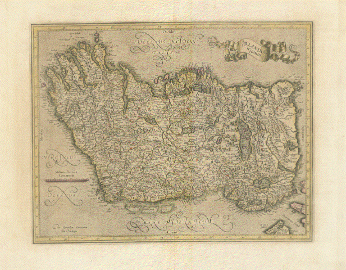
�Irlandiae Regnum". Ireland. West-oriented copper etching of Ireland by Gerard Mercator.
Hand coloring. Duisburg, 1595.Notice that this is an east-oriented map. East is at the top, north on the right, etc.
Important places are highlighted in red.The entire island of Ireland, designed and etched by the famous cartographer. Strong imprint.
The margins have light hardly visible folding lines from earlier framing.
Overall natural age toning. Centerfold has been reinforced and flattened.On the reverse side is text in French about Ireland.
33 x 41.5 cm (13 x 16.3").
$ 780.00
Order Nr. BRITISHISLES MAP1159
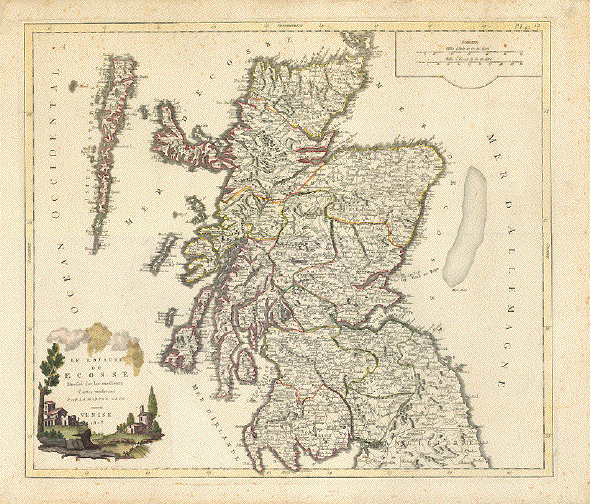
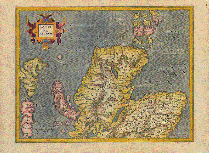
�Scotiae Regnum"
Outstandingly originally hand-colored copper etching by Gerard Mercator (1512-1594)
Published posthumously by Mercator's son Rumold in Duisburg, 1595
Printed on very thick paper of the first edition. Verso text: Latin
Shows northern part of Scotland with Orkney Islands and part of the Hebridean Islands.
Beautiful Renaissance title cartouche!
Map has general age toning. Right margin has two small repaired holes, well away from image. Centerfold has been reenforced. Light spotting and creasin in margins. General condition: Good.
35 x 45,5 cm (ca. 13.8 x 17.9")
$ 840.00
Order Nr.BRITISHISLESMAP238284
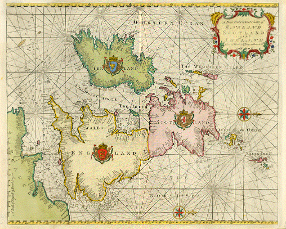
"A New and Correct Chart of England Scotland and Ireland". Copper etching from "The Coasting Pilot" published in London, 1759. Modern hand coloring. This map is rare.
For orientation, this map, as can be easily seen, is west-oriented. This very decorative, west-oriented map shows the coastal regions of the British Isles in great detail. All along the coast is information about the sand banks and water depth. The respective coats-of-arms have been artfully placed in the center of each country. The title cartouche in the upper right and two windroses add more to the decorative aspect of the map.
Except for light toning and small margins, the map is in Very Good condition.
44.9 x 55.2 cm ( 17.7 x 21.7 ")
Order Nr. BRITISHISLES MAP238156 SOLD
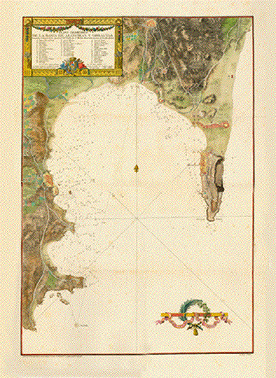
GIBRALTAR
�Plano Geométrico de lka Bahia de Algeciras y Gibraltar"
Copper etching by Juan Antonio Salb(v)ador Carmona (1740-1805). Lettering by Santiago Drouet.
Beautiful original hand coloring.
Published in Sea Atlas by Rear Admiral Vincente Tofiño San Miguel (1732-1795)
Dated 1786
Very impressive birs eye view of the Bay of Algeciras and Gibraltar. With a decorative Title and explanatory cartouche and a decorative mileage cartouche.
Wide Margins. Some ligtht spotting. Several vertical and horizontal folds because of sheer size.
Light creasing on folds.78 x 52,5 cm (ca. 30 x 20"
$ 1250.00
Order Nr.ESPAÑAMAPA238050
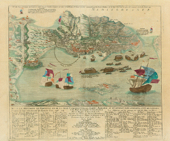
GIBRALTAR
�Vue de la Montagne de Gibraltar et de la Ligne Espagnole avec Algesiras et du Detroit come aussi de la Cote de l'Afrique"
Underneath French title: German title in translation
Copper etching by Johann Michael Probst.Augsburg, 1782
Dedication to Prince Beda Abbot in St. Gallen, Switzerland. �Ordine Supremo della Santissima Annunziata" in French and in German
Dedicated by Baron Thurn and his Regiment-Lieutennant Karl Kache
Splendid bird's eye view of Gibraltar in superb original hand-coloring
Legend on left in French. Legend on right in German
Very good condition. Very light general age toning
RARE, especially in this condition!
Print shows the �Great Siege", when, between1779 and 1783 Spanish and French troups tried in vain to wrest Gibraltar from the British.
48 x 55,5 cm including legend (ca 18.9 x 21.9")
$ 1600.00
Order Nr. ESPAÑAMAPA 238045
Map XIX Ireland
Wood engraving printed in color by Fisk & See in New York ca 1880.
Horizontal centerfold.28.5 x 23.5 cm ( 11.2 x 9.2 ")
$ 20.00
Order Nr. BRITISHISLESMAP1145
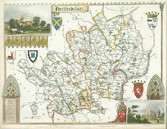
Hertfordshire. Anonymous steel engraving in fine original hand colorin of the county of Hertfordshire. With two insets: St. Albans Abbey and Cashiobury. Several coats of arms. 1837
What makes this map so interesting are the railroad lines and stations already engraved, although the London - Birmingham Railway opened only in 1838 and the Eastern Counties Railway fork reached Hertford only in 1843. So, at the time of printing, the trains were not yet running, but the lines from London to Birmingham and to Cambridge and Norwich (with the fork to Hertford) were entered into this map.
Very decorative map. Narrow margins. Mounted on heavier paper.
21 x 26.8 cm (8.3 x 10.6")
$ 140.00
Order Nr.BRITISHISLES MAP 11632
"Cornubia, Devonia, Somesettus, Dorecestria, Wiltonia, Glocestria, Monumentha, Glamorgan, Caermarden, Penbrok, Breknoke et Herford. " Copper etching by Peter Kaerius (1571-1646). Amsterdam, ca 1620. Verso text in Latin. Modern hand coloring.
Print has small wormhole in lower margin and two tinier holes in upper part of image that are hardly visible. Binding marks on left margin edge. Some ink marks from printing under title cartouch. Rubbing in lower left margin corner. Overall condition is Much Better than Good for a map this age.
14.4 x 20.3 cm ( 5.6 x 8 ")
$ 190.00
Order Nr. BRITISHISLES MAP 113
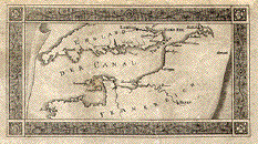
No Title. The Canal with Jersey and Gurnsey.
Copper engraving ca 1780. Age toning. Fraying on margin edges. A few creases.
7.4 x 13.6 cm ( 2.9 x 5.3 ")
$ 90.00
Order Nr. ENGLAND2151
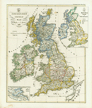
�Die Britischen Inseln bis auf Wilhelm den Erobere 1066". (The British Isles up to William the Conquerer 1066.) Steel etching by W. Alt 1846. Original hand coloring.
Insets: The realms and peoples on the British Isles in the 8th century. The Firth of Forth. Notice the regional divisions of the time.
Clean except for some foxing in margins.
Page size: 37 x 43.8 cm (14.6 x 17.2").
$ 120.00
Order Nr. BRITISHISLESMAP1149
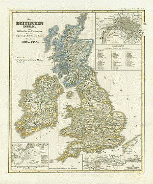
�Die Britischen Inseln von Wilhelm dem Eroberer bis zum Regierungs-Antritt des Hauses Tudor 1166 bis 1485". (The British Isles from William the Conquerer until the House of Tudor taking power 1166 - 1485.) Steel etching by C. Poppey. 1846. Original hand outline coloring.
Insets: Plan of London marking the most important spots within the city in the Middle Ages. Plan of battle of Bannockburne 1314. The lower run of the Themes river.
Clean except for some stains in the margins.
Page size: 37 x 43.8 cm (14.6 x 17.2").
$ 120.00
Order Nr. BRITISHISLESMAP1148
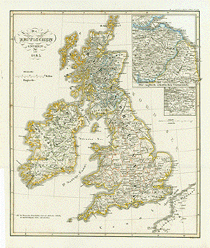
�Die Britischen Inseln seit 1485". British Isles since 1485. Steel etching by E. Luther. 1846. Original borderline coloring.
Insets: The English/ Scotch border areas. Surrounding of Glasgow.
Clean except for some stains in the margins.
Page size: 37 x 43.8 cm (14.6 x 17.2").
$ 120.00
Order Nr. BRITISHISLESMAP1147
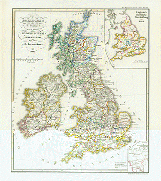
�Die Britischen Inseln nach ihrer kirchlichen Eintheilung bis zur Reformation". The British Isles accoring to their dioceses up to the Reformation. Steel etching by Joh. Carl Ausfeld. 1846. Original borderline coloring.
Insets: England's dioceses since 1543. Southern part of Lincolnshire.
Clean except for some stains in the margins.
Page size: 37 x 43.8 cm (14.6 x 17.2").
$ 120.00
Order Nr. BRITISHISLESMAP1146
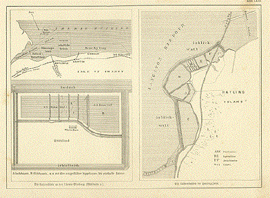
"Die Austernbaenke an der Themse-Muendung. Die Austernbassins der Hayling Insel"
(The Oysterbanks at the mouth of the Thames and Hayling Island)This map with diagrams shows the oyster culture on Hayling Island and the Isles of Thanet at the mouth of the Themse.
In the upper left are the names of some of the Oyster Fisheries, such as Faverham, Pollard, Ham and Whitestaple.Wood engraving ca 1890. Light brown spot in upper right corner and small spot on left edge.
16.5 x 23 cm ( 6.4 x 9 ")
$ 45.00
Order Nr. SHELL9229
"Das Koenigreich Grossbritanien und Ireland"
Steel engraving for Meyer´s Hand Atlas, 1868. Original outline coloring.
Interesting map showing the railway lines of the time as well as the lighthouses on the coasts. The dephs of the sea and the various currents are shown by special lines. Also shown are the most important mud and chalk banks.
Map has no side margins. At the top and bottom are dark areas caused by earlier framing. Overall light age toning.
36.5 x 29.5 cm ( 14.3 x 11.6 ")
$ 65.00
Order Nr. BRITISHISLESMAP237693