Cartographic Curiosities

Take a look at these interesting variations of mapmaking.

Antique maps may have some minoe signs of age and use.

Ordering and Payment

Lieferbedingungen

Sale! Discount!

30% Discount on All maps with a MAPCURIOSITY number on this page!

Take 30% off the listed price. !

We accept reasonable offers.

Visit us at the following sites:

https://lovelyantiqueprints.com

twitter.com/philographikon2

"Karte von Manulphus"

Highly interesting map of the lands bordering the Mediterranean Sea and those neighboring.

This wood engraving map is on a page of text about the sea traffic and trade
of the Venetians in the 14th Century. Text continues on reverse side. Published 1881.

Map size: 11.5 x 9 cm ( 4.5 x 3.5")

$ 35.00

Order Nr. MAPCURIOSITY253117


"Toscanelli's Erdkarte"

This map shows Spain and Africa on the right and Japan, China and Malaysia on the left.
The Americas were not yet discovered. The map maker, doctor, astronomer Paolo
dal Pozzo Toscanelli (1397-1482) was a Florentiner.

This map was published 1881. Light browning on margin edges.

Map image: 10 x 14 cm ( 3.9 x 5.5")

$ 45.00

Order Nr. MAPCURIOSITY255315


"Erdkarte nach Pomponius Mela"

Wood engraving image n a page of text (in German) about very early maps.
Text contnues on the reverse side. Published 1881.

Diameter of map: 9 cm (3.5")

$ 40.00

Order Nr. MAPCURIOSITY255312


*********

Reverse side:

"Von den Inseln" (About islands)

Woodcut.

Published in "Cosmographia" by Sebastian Muenster (1488-1552)

Basel, 1553

Muenster describes this fictitious map showing inhabited islands and 16th century sail ships as "places you cannot reach with dry feet". Probably inspired by new discoveries in Central America Muenster - up to date in news - depicts what had been reported by explorers. Naturally he makes sure to make over serves shudder at the sight of some sea monsters.

Full page. There are water stains on left, upper and lower margins. The lower margin has been supported with acidy paper. But the image of the islands is in very good condition. There is German text print below and verso with the complete article about "Islands" and above (unrelated) and verso. This page is number 3 i the Cosmographia

Image: 10,2 x 14,5 cm (ca. 4 x 5.7")

Page size: 31 x 20 cm (ca. 12.2 x 7.9")

$ 120.00

Order Nr.MAPCURIOSITY253162


"Erdkarte nach Aethikus aud dem 8. Jahrhundert"
(Earthmap by Aethicus from the 8th Century)

In the center is the Mediterranean Sea. At the top is India and Persia.
In the lower left is Spain and in the lower right Mauritania.

Map on a page of text about early mapmaking that continues on reverse side.
Published 1881.

Map image: 12 x 10.5 cm ( 4.7 x 4.1")

$ 40.00

Order Nr. MAPCURIOSITY253116


"Die Legende des heiligen Brandanus"

St. Brendans Island is a mystical island in the Atlantic. This fascinating image
shows the island in the upper area. In the lower left are the Isulae Fortunatae ( Canary Islands ). A priest is saying Mass on the back of the fish with a small group.
In the lower area is St. Brendan and two other monks.

Wood engraving published ca 1900. n the reverse side is unrelated text.

Image: 8.5 x 11 cm ( 3.3 x 4.3 ")

$ 75-00 minus 30% Discount = $ 52.50

Order Nr. MAPCURIOSITY255921


"Der heilige Brandanus auf der Weltkarte der Bruder Pizzigani vom Jahre 1367"

Wood engravng of St. Brandanus standing in the Atlantic Ocean looking at the Canary Islands.
This image is taken from the famous Pizzigiani (Pizzigiano) Portolan Chart of 1367.
This image was published about 1900. Below the image and on the reverse side of the page
is text about early map making and exploration. The text does not include information
about this map or the Canary Islands. The rexr contunues on a separate page.

Image: 9.8 x 11.8 cm ( 3,8 x 4.6")

$ 45.00

Order Nr. MAPCURIOSITY254834


No Title

Very special handmade map that shows a lot of imagination. Possibly for an engaement or wedding present.

Probably made ca 1840-1850.
Painted with watecolor ( aquarell ) and brown ink.
The margin is finely embossed. Mounted on paper backing.
Small corner of the backing is missing.Some creasing in margins.

Map image (brown line border): 10 x 17 cm ( 3.9 x 6.6 ")
Map size with embossed border: 12 x 19 cm ( 4.7 x 7.4 ")

$ 220.00

Order Nr. MAPCURIOSITY249725


"Weltbild des Pomponius Mela"

Wood engraving made after the original map in the Library of Rheims.
Published ca 1900.

Below the map and continuing on the reverse side is an article about
history and geograpy in the Middle Ages.

Page size: 25 x 18 cm ( 9.8 x 7")

Order Nr. MAPCURIOSITY253712SOLD


Landverbingungen zwischen Europe and Africa

"Darstellung der alten Landverbindungen zwischen Europa und Afrika vor der Eiszeit"

Wood engraving after Professor. W. Bond Dawkins showng the land connections between Europe
and Africa before the Ice Age.Published ca 1900. Reverse side is printed.

8 x13 cm ( 3.1 x 5.1 ")

$ 30.00

Order Nr. MAPCURIOSITY246813


"Die Landung des Columbus auf Española"

Wood engraving made after an early document that was printed in 1494 in Basel, Switzerland.
This map was published ca 1900.

Page size: 16.5 x 25 cm ( 6.4 x 9.8")

$ 40.00

Order Nr. MAPCURIOSITY253923


"Ein Abschnitt des Peutringerischen Tafels" (a sectin of the Peutinger map)

Wood engraving published 1881.Reverse side is printed.
Light natural age toning.

Image: 11 x 17 cm ( 4.3 x 6.6")

$ 25.00

Order Nr. MAPCURIOSITY255314


"Edrisi's Erdansicht um 1150"

Edrisi ( Abu abdallah Muhammed al Idrisi (1100 in Ceuta, Spain - 1165 in Ceuta Spain).

Wood engraving on a page of text about very early maps and exploration showing how various
peoples understood the world. Text continues on revrse side.
Published 1881.

Image: 11 x 11 cm (4.3 x 4.3")

$ 40.00

Order Nr. MAPCURIOSITY253115


"Andrea Bianco's Erdkarte"

Andrea Bianco made at least ten maps of the known world.

Wood engraving on a page of text about maps msde by Andres Bianco and Marino Sanuto.
Text continues on revrse side. Published 1881.

Image: 10 x 10 cm (3.9 x 43.9")

$60.00 minus 30% Discount = $ 42.00

Order Nr. MAPCURIOSITY255937


Zeig und Schlag-Uhr

ãGeographische Universal - Zeig und Schlag-Uhr"

Copper etching. Original hand coloring. Published by Johann Baptist Homann in Nuremberg.Ca. 1730/40.

Astronomical clock showing the northern hemisphere in day and night during the course of sun and earth for 24 hours. The legend left and right of clock explains the astronomical connections. It is surrounded by the Zodiac symbols. For collectors: California is shown as an island.

The clock was built by famous Nuremberg clock maker Zacharias Land(t)eck

Except for some traces of age and use: Very good condition. The narrow margins have been professionally widened.

Ca. 49 x 57,5 cm (ca. 19.3 x 22.6")

$ 1200.00

Order Nr. MAPCURIOSITY248197

Details:

California as an Island

Signs of Zodiac


Homer's Earth

"Die Erde nach der Vorstellung Homers" ( the earth according to Homer )

WoOd engraving after Thomas published ca 1900.Map is on a page of text
that continues on reverse side.

11 x 11 cm ( 4.3 x 4.3 ")

$ 35.00

Order Nr. MAPCURIOSITY246814


"Himmel und Erde nach der Vorstellung der Babylonier"

Chromolithograph by P. Jensen after M. Raenicke. Published in Berlin 1915.

This very interesting print shows how the Babylonians understood the world in relation to the sky.
The text in German explains the aspects of their understanding.

Image without text: 13 x 19.5 cm ( 5.1 x 7.6 ")

Order Nr. MAPCURIOSITY245110SOLD


"Oriens"

"Occidens"
"Noachiden Erdkarte aus dem 11 Jahrhundert"
( Map of the decendents of Noah in the 11th Century)

Wood engraving on a page of text about very early maps showing how various
peoples understood the world according to their beliefs. Text continues on revrse side.
Published 1881.

Image: 10.5 x 10.5 cm ( 4.1 x 4.1")

$ 35.00

Order Nr. MAPCURIOSITY252948


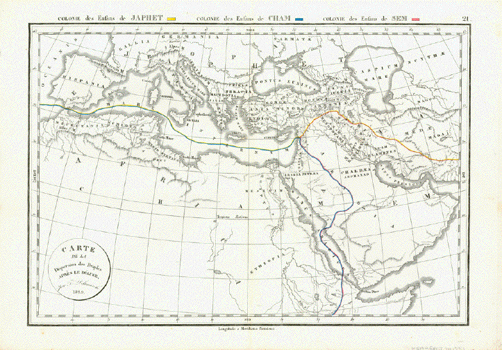
"Carte de la Dispersion des Peuples après le Deluge"

Map of the dispersion of people after the deluge

Colonie des Enfents de Japhet - marked in yellow original color

Colonie des Enfents de Cham - marked in blue original color

Colonie des Enfents de Sem - marked in red original color

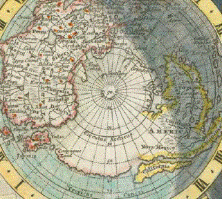
According to the Old Testatement Noah had three sons: Japhet, Cham and Sem

According to Flavius Josephus these three sons moved to different areas after the deluge (ca. 100 A.D.) This maps shows the areas to which people moved. And the map states: Colonie des Enfans de Japhet (yellow coloring), Colonie des Enfans de Cham (blue coloring) and Colonie des Enfans de Sem (reed coloring).

Copper engraving from:"Atlas de la Geographie ancienne, du moyen-age et moderne". By Felix Delamarche, who followed his father Charles Francois Demarche (1740-1817) in his cartographic business.

Paris, dated 1829

Map has light general age toning and shows some minor traces of age an use

27,5 x 39,8 cm (ca. 10.8 x 15.7")

$ 240.00

Order Nr.NEAREASTMAP241751


Ranulf Higden

"Weltkarte des Ranulfus Hyggeden aus dem 14 Jahrhundert" ( Ranulf Higden )

The original of this map is in the British Museum.

Published ca 1900. Reverse side is printed.

18.5 x 13.5 cm ( 7.2 x 5.3 ")

$ 70.00

Order Nr. MAPCURIOSITY249033


"Tiergeograhie" ( Animal geography )

Map showing the habitats of various animals published 1895. In the lower left is a
color key showing the climatic regions of habitat and lines of various design showing the animals that live in the region.

Map has folds to fit original book size. Light age toning along ceterfold.

Image 28.5 x 51.5 cm ( 11.2 x 20.2 ")

$ 40.00

Order Nr. MAPCURIOSITY244027


Globe by Martin Behaim

"Ozean Seite auf dem Globus des Martin Behaim aus dem Jahre 1492"
( Ocean side of the globe by Martin Behaim in 1492 )

Very interesting map from the globe of Martin Behaim with Europe and Africa on the right side
and Japan, Asia and Southeast Asia on the left side.This map was made before the discovery of
the American Hemisphere. In the ocean are the Canary and Cape Verde Islands off the coast of Africa.
On the left side are the islands of Japan and the Philippines off the coast of Asia.

This map was made after Knrad Kretchmer and published 1900. Reverse side is printed.

Diameter: 13 cm ( 5.1 ")

$ 45.00

Order Nr. ATLANTICMAP248793


"Tiergeographie"
"Tierverbreitung in Deutschland"
( Animal habitat in Germany )

In the lower right is a key with various line designs that shows the habitat regions of the birds,
fish and other animals in Germany. Published in 1895.

Light age toning. Vertical centerfold.

Image: 21 x 27 cm ( 8.2 x 10.6 ")

$ 20.00

Order Nr. MAPCURIOSITY244026


"Chorographia Originis Nili Sevfontium Ipsius"
"Karte des Nilquellen-Gebietes und arabischer QAuffassung"
"Die Nilquellen entspringen auf den Mondbergen (montes lunae)"

Interesting map of the origins of the Nile River. This copy of this ancient
map was published in a German illustrated work in 1902. The image is on a
page of text about very early African map making that continues on the
reverse side of the page.

Image: 11 x 9.5 cm ( 4.3 x 3.7")

$ 35.00

Order Nr. MAPCURIOSITY254838


"Comparative Size: Lakes / Islands"

Upper image left: "Lakes in the Western Hemisphere. "
Upper image right: "Lakes in the Eastern Hemisphere"
Lower left image:Islands in the Western hemisphere"
Lower right image: Islands in the Eastern Hemisphere"

Type of print: Lithograph

Color: Original hand coloring

Publisher: George W. Colton

Published in: "Colton's Atlas of the World illustrating physical and political geography"

Published: New York, 1856

Overall pleasant light age toning. Minor signs of age and use.

32 x 39.5 cm ( 12.5 x 15.5 ")

Order Nr.WORLD239573SOLD


Upper image: " Erdkarte nach dem Vorbild des Tisches der mosaischen Stiftshuette"
Lower image: "Die Erde von den Himmelsmauern umschlossen"

"Grundriss des die Erde bildenden Berges"

"Die Ursachen der langen und kurzen Naechte"

Three pages with wood engraving images showing some of the very eary maps that were drawn to
explain natural phenomenon. Published 1905.

Page size: 26 x 19 cm ( 10.2 x 7.4 ")

Price for the three pages: $ 45.00

Order Nr. MAPCURIOSITY 246278


"Asia-Europa in Beziehung auf das Fliessende und seine Vertheilung in Stromgebiete." Steel etching from "Neuster Zeitungs Atlas. Alter und Neuer Erdkunde" by J. Meyer, ca 1855. Original outline coloring.

Map shows the "Fliessende" (means flowing) with the many rivers in great detail in Europe and Asia.

Map is clean. Thin fold on right side. Tiny repaired tear on left margin edge.

21 x 29.5 cm ( 8.2 x 11.6 ")

$ 85.00

Order Nr. WORLD2231


"Weltkarte des Fra Mauro aus dem Jahre 1459"

Wood engraving after a drawing of an old map. Published ca 1900.
Image is on a page of German text that continues on the reverse side.
Text is about early exploration, especially about the area of the Indian Ocean.

Diameter: 11 cm ( 4.3 ")

Order Nr. MAPCURIOSITY249447 SOLD


" Karte von Europa. Zur Uebersicht der Waerme-Verbreitung in diesem Erdtheile". Steel etching from "Neuster Zeitungs Atlas. Alter und Neuer Erdkunde" by J. Meyer, ca 1855. Original outline coloring.

Map illustrates the warming patterns with colored lines from northern Africa to the Polar Circle.

Light browning of margin edges. Otherwise the condition is Almost Very Good.

20 x 27 cm ( 7.8 x 10.6 ")

$ 70.00

Order Nr. EUROPE2497


"Erdkarte nach der Auffassung des Homer reknstruiert"

This map was made after the ideas of Homer. Published ca 1900.

Image is on a page of text that continues on reverse side.

Diameter: 11 cm ( 4.3 ")

$ 45.00

Order Nr. MAPCURIOSITY249034


"Die Isothernkurven Der Noerdlichen Halbkugel". Steel etching from "Neuster Zeitungs Atlas. Alter und Neuer Erdkunde" by J. Meyer, ca 1855. A bit of original outline coloring.

Map shows a polar projection of the world. The isothermic curves are shown, starting in the polar area. At the bottom left and right are diagrams of the temperature and snow levels of the major world mountains. In the lower left are mts. of the americas and in the lower right are those of Europe and Asia.

Map is very clean. Side margins are narrower. General condition is otherwise almost Very Good.

25.2 x 29.5 cm ( 9.9 x 11.6 ")

$ 110.00

Order Nr. WORLD2228


"Die beiden Erdhalbkugeln nach dem Behaim'schen Globus"

Wood engravings on a page of text that continues on the reverse side.
Also on the reverse side is a portrait of Martin Behaim leaning on a globe.
Text is about early mapmaking and exploration.
Published 1876.

Page size: 24 x 14.5 cm ( 9,4 x 5.7")

Order Nr. MAPCURIOSITY254224 SOLD


"America Karte vom Laufe des Orinoco des Atabapo des Casiquiare und des Rio Negro" Steel etching from "Neuster Zeitungs Atlas. Alter und Neuer Erdkunde" by J. Meyer, ca 1855. Some original outline coloring.

This very interesting map shows the tributaries of several major world rivers. On the left side is the Orinoco. The inset in the lower left corner shows the Vasvia section of the river and to the right is a detailed inset of the currant and waterfalls of Maypures. In the upper right is a very detailed section of the Arno and Chian rivers that shows the region from Mt. Cimone as far south as Rome and the mouth of the Tiber. Another inset shows the connection of the Haase and Else with the Weser. In the lower right is Asia with the tributary system of The Irawadi, Panlaun, Mobraeh, Zittaun and Saluaen.

Tiny repaired tear in lower margin.

21.7 x 28.5 cm ( 8.5 x 11.2 ")

$ 90.00

Order Nr. SOUTHAMERICA2130


"Weltkarte des Aba Abdallah Muhammad al Edrisi ( 1154 )"

Wood engraving published ca 1900 made from a drawing of an old map.
The image is on a page of text about very early Arabic mapmakng.
The text continues on the reverse side.

The map image is light but easily readable.
Small corner of lower left margin is missing but not affecting the text.

Diameter: 13 cm ( 5.1 ")

$ 45.00

Order Nr. MAPCURIOSITY255034


"Karte Der Magnetischen Meridiane und Parallel-Kreise." Steel etching from "Neuster Zeitungs Atlas. Alter und Neuer Erdkunde" by J. Meyer, ca 1855. Original outline coloring.

Map shows the magnetic meridians looking from the poles.

Map is in Almost Very Good Condition.

25 x 29.5 cm ( 9.8 x 11.6 ")

$ 90.00

Order Nr. WORLD2229


"Mittelalterliche Erd-Karte"
"Nach einem angeblich aus dem 12 Jahrhundert stammende Manuscript
on der Bibliothek zu Turin"

Wood engraving on a page of text. Reverse side is printed.

11.5 x 12.5 cm ( 4.5 x 4.9 ")

$ 35.00

Order Nr. MAPCURIOSITY249910


"Ibn al Wardi's (Sanudo's) Erdkarte"

Wood engraving map on a page of text about early map making that continues on reverse side.

Published 1881.

Diameter of map: 10.5 cm ( 4.1")

$ 40.00

Order Nr. MAPCURIOSITY253060


"Das Weltgebaeude des Kosmas Indikopleustes"

Fascinating understanding of the world by Kosmas Indikopleustes (died 500 AD).
On the left is the Sol Occidens and on the right Sol Oriens.
This wood engraving is on a page of text with information about Kosmas Indikopleustes
and early map making that continues on the reverse side of the page.
Published ca 1905.

Image: 6.5 x 8.5 cm ( 2.5 x 3.3")

$ 30.00

Order Nr. MAPCURISITY255O63


Upper image: "Welttafel des Edda."
Lower image: "Trinkgelage der nordishe Goetter"

Wood engravings on a page of text about Nordic mythology.
On the reverse side is unrelated text. Published 1875.
Overall natural age toning.

Page size: 26 x 20 cm ( 10.2 x 7.8")

$ 45.00

Order Nr. MAPCURIOSITY254261


"Weltkarte von Alby (8. Jahrhundert)

Very interesting wood engraving of the world with Spain and Maurtania
in the lower part and India and Babylonia at the top.
The text is about very early mapmaking and continues on the reverse side.
Published ca 1900.

Image: 8.5 x 7 cm ( 3.3 x 2.7"

$ 35.00

Order Nr. MAPCURIOSITY255033


"Landkarte auf einem aegyptischen Papyrus aus der Zeit Ramses II"
(Map made at the time of Ramses II on papyrus)

This wood engraving map after Adolf Erman was first published in 1877.
This map is on a page of ext about early maps that continues
on the reverse side and was published about 1900.

Image: 8 x 10.5 cm ( 3.1 x 4.1")

$ 35.00

Order Nr. MAPCURIOSITY254728


"Auschnitt aus der Herfordkarte des Richard von Haldingham aus dem 13. Jahrhundert"
(Section of the Herford map of Richard von Haldingham from the 13th Century)

This map published ca 1900. Vertical centerfold.
Reverse side is printed with text about early mapmaking,
Very light natural age toning.

Map image with title: 22 x 31 cm ( 8.6 x 12.2")

$ 55.00

Order Nr. MAPCURIOSITY254917


Maps of the World

Town and City Views of the World

Ordering and Payment

E-mail

Terms of Sale - Lieferbedingungen

Home Page

Impressum

Datenschutz

© Rainer Rauhut