twitter.com/philographikon2
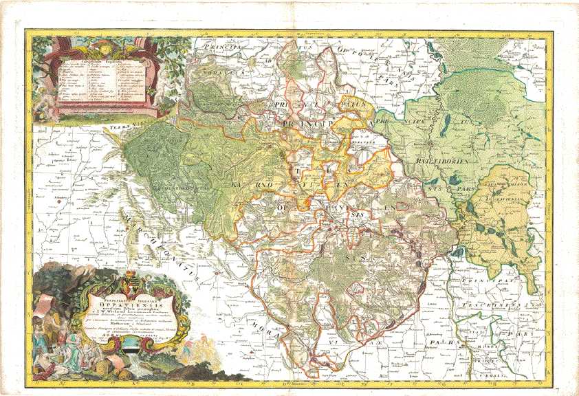
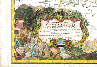
"Principatus Silesiae Oppauiensis novissima Tabula geographica a I.W.Wieland Locumtenente Caesareo accurate delineata, ob praematuram mortem auctorisdenuo rectificata per Caesareum Locumtenentem et Architectum militarem Matthaeum a Schubarth ac Sumptibus Principum et Ordinum Silesiae reducta et excusa Norimb. ab Haeredibus Homannianis A.O.R MDCCXXXVIÉ"
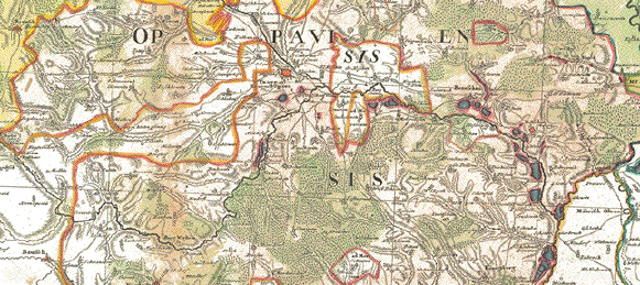
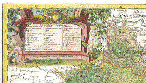
Fuerstentum Oppau (heute grossenteils in Tschechien) mit Leobschütz (Polen), Jaegerndorf (Tschechien), Troppau (Tschechien). Handkolorierte Kupferstichkarte nach Zeichnung von Johann Wilhelm Wieland (? - 1736) und nach dessen Tod ueberarbeitet von Matthaeus Schubart (? - 1758). Aus dem "Atlas Silesiae". Herausgeber: Homann Erben, Nürnberg. Die Karte ist 1736 datiert und gedruckt. Der Atlas mit insgesamt 18 Kupferstichkarten ( zwei Übersichtskarten und 16 Fürstentuemer) im Gross-Folio-Format wurde insgesamt aber erst 1750 herausgegeben. Mit handkolorierter barocker Titelkartusche (mit Wappen des Fürstentums) und Legendenkartusche. Sehr detailliert.
Kaum nennenswerte Alters- und Gebrauchsspuren.
Principality of Oppau (Oppawa). Hand-colored copper etching after the drawing by Johann Wilhelm Wiegand (? - 1736) and, after his death, revised by Matthaeus Schubarth (ß - 1758). Published in the "Atlas Silesiae". Published by Homann Heirs in Nuremberg. The map is dated and printed in 1736, although the complete atlas with 18 grand-folio-size maps was published in its entirety in 1750. This very large map shows much detail. Even small villages are mentioned. Principality of Oppau, nowadays partially in the Czech Republich and partially in Poland. Very detailed and very decorative cartouches and hand coloring.
Hardly any traces of age and use.
55 x 81,8 cm (ca. 21.7 x 32.2")
$ 1300.00
Order Nr.DEUTSCHLAND248608
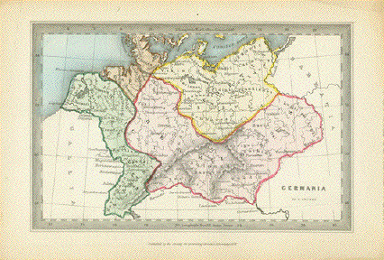
"Germania"
Rare copper engraving map by Joshua Archer (1792-1863)
Published by the Society for Promoting Christian Knowledge in 1847.
Very attractive original hand coloring. Historical names (Latin-Celtic) of places and peoples.
In the upper right is the Vistula River emptying into Gdansk Bay.
In the lower right is Vindobona and the Danube River.
In the lower left is the Nekar River (Nicer).
The eastern part includes parts of Poland, Czech Republic and Slovakia.
In the upper left is Frisland.
Natural age toning in margins.Map image: 9 x 14 cm ( 3.5 x 4.5")
$ 220.00
Order Nr. DEUTSCHLAND255157
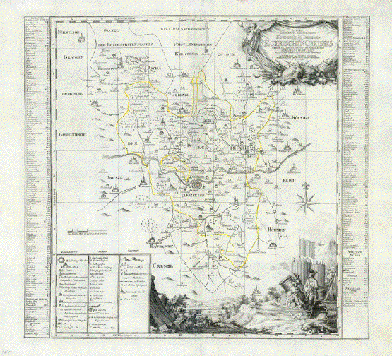
ăAccurate Geograph. Delineation des zu dem Koenigreich Boehmen gehoerigen Egerischen Creisses nebst allen darin befindlichen Staedten und Dörfern auch allen daran grenzenden Gegenden in Amsterdam bey Petrus Schenk..."
Copper etching (with original borderline hand-coloring) Published by: Peter Schenk. Amsterdam. Dated 1757
This map is a very detailed map of the city of Eger, which is now called Cheb.
Every village, every hamlet around the city of Eger is cartographed. Two columns left and right list in alphabetical order all places and their coordinates for this map. Keys for signs and abbreviations are marked in lower left corner. Two baroque cartouches enhance this beautiful map.
Diese Karte ist ein Schmuckstück für alle ehemaligen Egerländer. Sie zeigt namentlich jedes Dorf, jeden Weiler, jeden Fluss, Wald, Berg, Bach. Links und rechts die Liste in alphabetischer Reihenfolge. Zeichenerklärung unten links. Zwei Barock-Kartuschen verschönern die Karte zusätzlich.
Good condition. Minor traces of age and use.
47 x 49,5 cm (ca. 18.5 x 19.5")
Order Nr.CZECHMAP237485SOLD
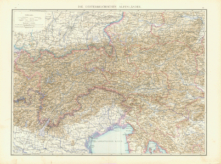
"Die Oesterreichischen Alpenlaender"
Map image: 36 x 47 cm ( 14.1 x 18.5")
********
Reverse side:
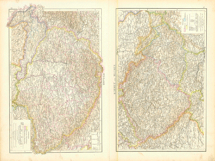
Left map: "Ungarn"
Map image: 23 x 38 cm ( 9 x 14.9")Right map: "Boehmen und Maehren"
23 x 36 cm ( 9 x 14.1")
There is a color key in the lower right corner of both maps showing
the political divisions at the time.These maps were printed in color ca 1890 on both sides of strong paper.
There is a vertical centerfold in the Austrian map and on the reverse side between the two maps.A few signs of age and use in the margins.
$ 80.00 minus 30% Discount = $ 56.00
Order Nr. AUSTRIAMAP255958
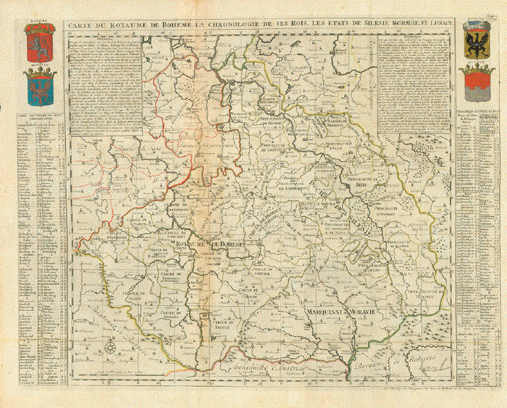
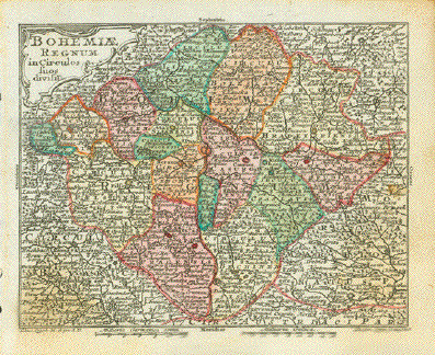
"Carte de Royaume de Boheme la Chronologie de ses Rois, les Etats de Silesie, Moravie et Lusace"
Kingdom of Bohemia - its chronology of kings and the states of Silesia (Poland), Moravia and Lusatia (Germany)
Copper etching. in the upper left and right corners of print in original hand coloring:
Coats of Arms of: Bohemia, Moravia, Silisia and Lusatia
Published in "Atlas Historique, Ou Nouvelle Introduction A l'Histoire, à la Chronologie & à la Géographie Ancienne & Moderne: Représentée dans de Nouvelles Cartes, Où l'on remarque l'établissement des Etats & empires du Monde, leur durée, leur chûte, & leurs differens Gouvernemens"
Amsterdam, 1705 - 1720
Very good condition. Map has two vertical and one horizontal fold to fit atlas size.
Light natural browning along centerfold.Clean. Light general age patina.
47 x 62,5 cm (ca. 18.5 x 24.6")
$ 260.00
Order Nr. CZECHMAP254139
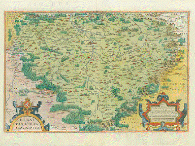
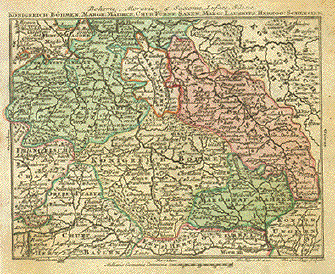
"Regni Bohemiae Descriptio" Copper etched Renaissance map from the first world atlas ăTheatrum Orbis Terrarum" by Abraham Ortelius, Antwerp, 1570. This is a map from the very rare first edition. Reverse text is Latin. Page number is 47. Renaissance watermark is crossed arrows. Hand coloring most likely from the 20th century.
Map shows heart-shaped Bohemia, surrounded by mountains and forests. The entire run of the river Moldau and the run of the river Elbe from its source to just north of Lerimaritz. Two decorative Renaissance cartouches.
Condition: Very good!
33.2 x 50.4 cm (13 x 19.8")
$ 580.00
Order Nr. CZECHMAP234616SOLD
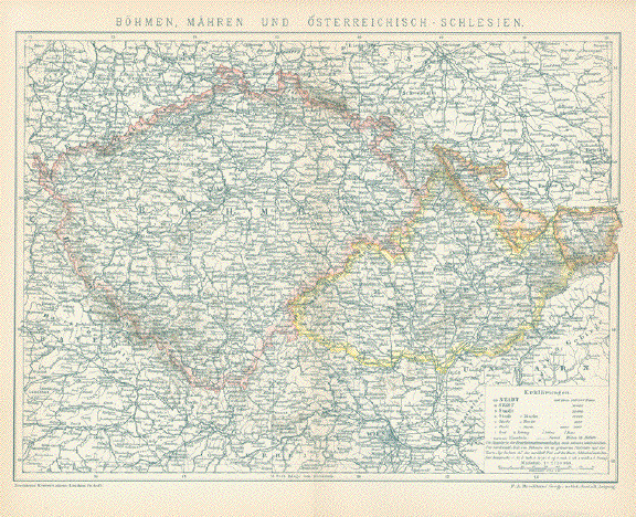
"Boehmen, Maehren un Oesterreichisch Schlesien"
Detailed historical map, 1894.
Map has overall light age toning. Vertical centerfold.
21.5 x 28.5 cm ( 8.4 x 11.2 ")
$ 25.00
Order Nr. CZECHMAP242396
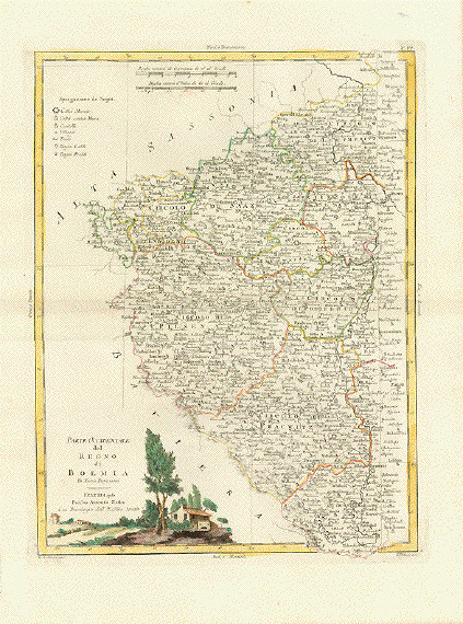
ăParte Occidentale del Regno di Boemia Di Nuova Projezione"
ăParte Orientale del Regno di Boemia Di Nuova Projezione"
Double map. Each one individual, but fitting together.
Type of prints: Copper etchings
Color: Original hand coloring
Publisher: Antonio Zatta (1757-1797)
Published in: "Atlante Novissimo"
Where: Venice
When: Dated 1779
Condition: Near excellent. only the faintest traces of age. Wide margins
Measurements:
Occidente: 40 x 30,5 cm (ca. 15.7 x 12")
Oriente: 40 x 31 cm (ca. 15.7 x 12.2")
Price: for the two maps.
Order Nr. CZECHREPUBLIC238591SOLD
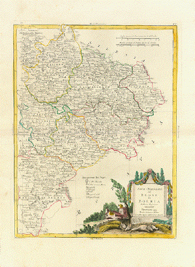
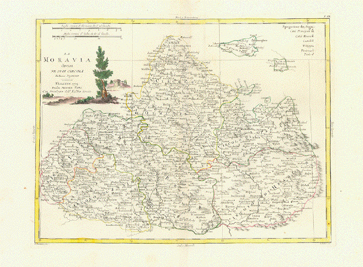
"La Moravia divisa Ne Suoi Circoli Di Nuova Projezione"
Type of print: Copper etching
Color: Original hand coloring
Publisher: Antonio Zatta (1757-1797)
Published in: Atlante Novissimo
Where: Venice
When: Dated 1779
Condition: Near excellent. only the faintest traces of age. Wide margins
Measurements: 31 x 40,5 cm (ca. 12.2 x 15.9")
Price: $ 180.00
Order Nr. CZECHMAP238590
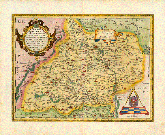
"Moraviae Quae Olim Marcomanorum Sedes, Corographia, A.D. Pavlo Fabritio Medico et Mathematico Descripta; et a Generosis Moraviae Baronibus Quibusdam corecta"
Map shows Moravia nowadays: Slowakia
Hand-colored copper etching
Publisher: Abraham Ortelius
Publication: Theatrum Orbis Terrarum" - the first atlas ever published.
Where: Antwerp, Belgium
When: 1590
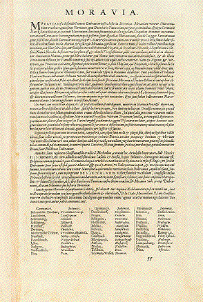
Reverse side: Text in Latin
Condition: Very good. Wide margins. Only minimal traces of age and use.
Measurements: 35 x 46,7 cm (ca. 13.8 x 18.4")
Order Nr.CZECH238190SOLD
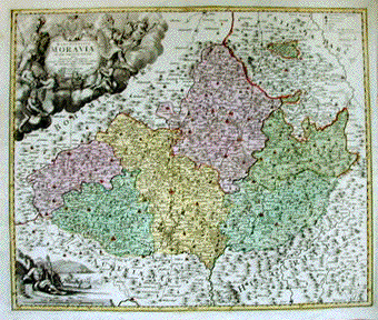
Reverse:
"Tabula Generalis Marchionatus Moraviae om sex circulos divisae". Copper engraving by J. Christoph Mueller for Joh. Bapt. Homann ca 1715. Original hand coloring.
Map shows the six divisions of Moravia at the time. In the center of the map is Prostnitz. In the upper left is a very decorative cartouche with allegorical figures and a coat-of-arms. This is the area of Bohemia. In the lower left is another decorative scene in the part that is Austria. In the upper right is part of Silesia with the Oder river and in the lower right is part of Hungary.
Map is printed on stron paper. Vertical centerfold. A few spots in margins and some minimal ink writing on backside.
48 x 57 cm ( 18.8 x 22.4 ")
Order Nr. CZECHMAP1124 SOLD
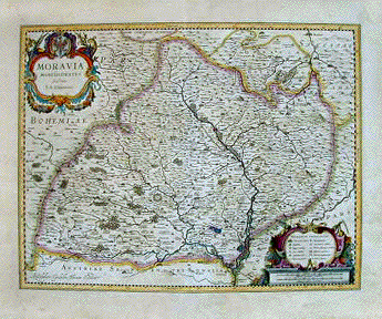
"Moravia Marchionatus". Copper engraving by I.A: Comenio for Wilhem Bleau , ca 1600. Original hand coloring.
The Moravia river dominates the ceenter of this detailed map. Prostnitz is located almost in the center. In the upper right is part of the Oder River with the towns of Oderberg Ratibor and Freistatt. In the lower right is a bit of Hungary. Located around the titel cartouche is Bohemia. The backside is printed (in German) with information about Maehren.
Map has overall light age toning and browning in margins. Some scattered spotting in margins. Vertical centerfold and a few creases in margins. Small repairs on upper margin edge.
37.5 x 48.5 cm (14.7 x 19 ")
$ 480.00
Order Nr. CZECHMAP1125
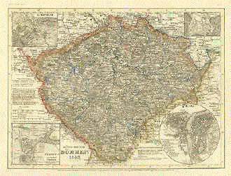
"Koenigreich Boehmen". Steel etching from "Neuster Zeitungs Atlas. Alter und Neuer Erdkunde" by J. Meyer, ca 1855. Some original outline coloring.
Prag is in the center of this very detailed map. The inset in the upper left shows Karlsbad and the surrounding are. The inset in the upper right is of Marienbad. In the lower left is a detailed plan of Teplitz and Schoenau. The circular inset in the lower right is a streetplan of Prag. At the bottom center of the map is Helfenberg in Austria. In the upper left under the inset is Hof, Naila and Münchberg. At the top center of the map is Loban and Bernstadt in Saxony.
Map has light browning on margin edges. In the lower right margin corner is a bit of smudging. Otherwise Better than Good condition.
18.3 x 24.7 cm ( 7.2 x 9.7 ")
Order Nr. CZECHMAP1123 SOLD