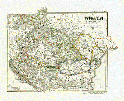
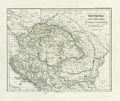
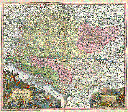
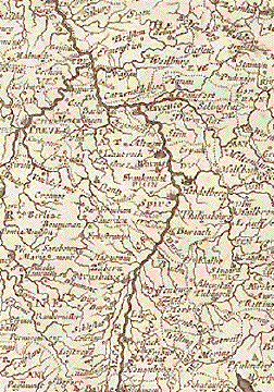
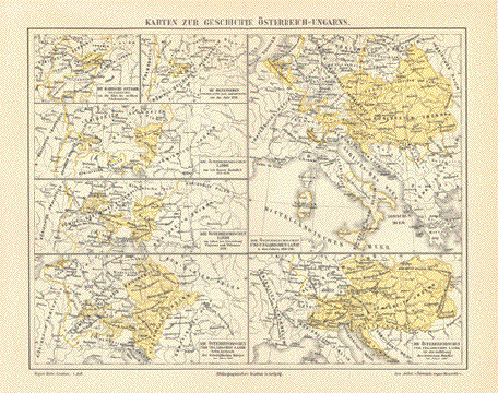
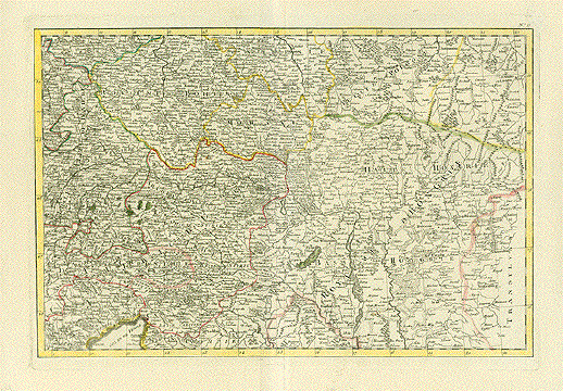
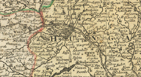
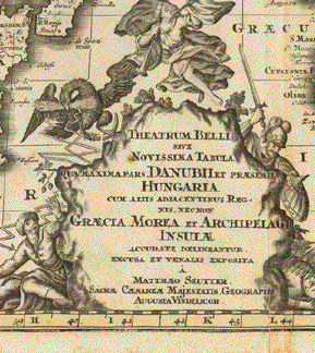
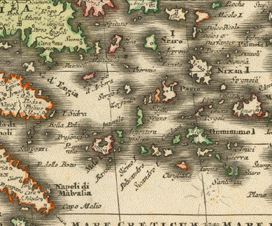
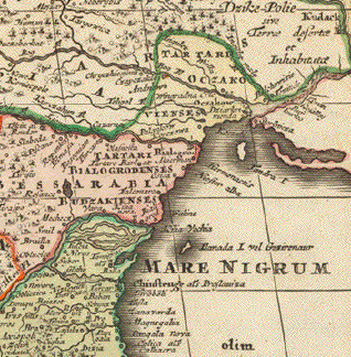
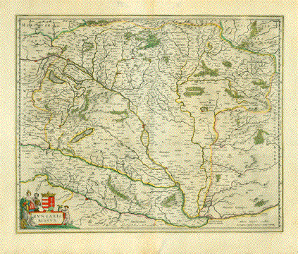
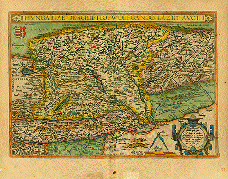
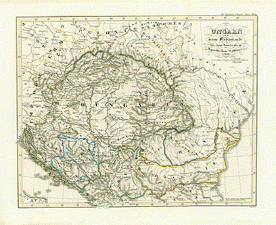
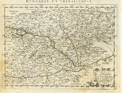
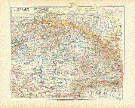
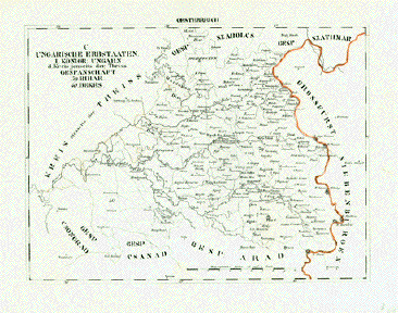
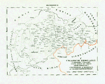
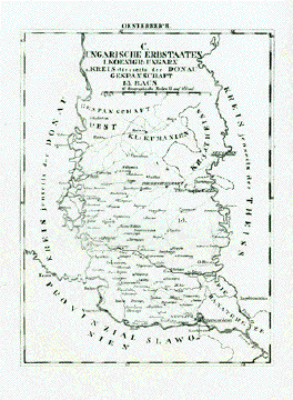
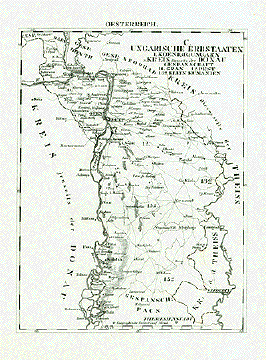
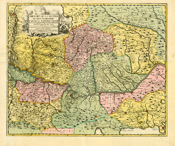
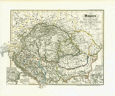
|
Antique Maps of Hungary View our selection on historical maps of Hungary. If you are looking for a particular map, or a certain city or town that may be on these maps, please contact us. Maps have wider margins than shown and normal age toning. |
|
“Principatus Transilvaniae in suas quaque nationesearumque sedes et Regiones..."Copper engraving by Johann Baptist Homann. Original hand coloring. Nuremberg, 1723. Map centers on Transilvania, also showing parts of Vallachia, Comitatus Temesiensis, parts of Moldavia and Hungary. Very nice map. Clean and attractive. Small repaired tear in lower margin. 48 x 57.5 cm (18.9 x 22.6") $ 580.00 Order Nr. HUNGARY1255 |
|
"Ungarn und Siebenbürgen. 1849". Steel etching from "Neuster Zeitungs Atlas. Alter und Neuer Erdkunde" by J. Meyer, ca 1855. Original outline coloring. Map shows Hungary and Siebenbürgen in 1849. In the upper right is an inset of Pesth and Offen. Clean map in good condition. 18.3 x 24.7 cm ( 7.2 x 9.7 ") $ 75.00 Order Nr. HUNGARY1248 |
|
"Regni Hungariae Tabula Generalis." Copper etching by Tobias Conrad Lotter ( (1717-1777) after Tobias Lobeck for the "Atlas Geographicus portabilis" (Pocket-size atlas) published 1760-1762. Original hand coloring. Map shows the Hungarian empire and surrounding area. Map reaches to western Moldavia on the right side and as far west as Karlstadt and Landsberg on the left side. In the lower right is a bit of Bulgaria. Map has a few minor spots in margins. 9.4 x 12.2 cm ( 3.7 x 4.8 ") $190.00 Order Nr. HUNGARY1249 |
|
"The Mape of Hungari newly augmented by John Speede Ano Dom: 1626" Copper etching by Abraham Goos for the atlas “A Prospect of the Most Famous Parts of the World".by John Speed (1552 - 1629) which was published in London, 1627. The atlas was the first world atlas published by an Englishman. Text on reverse side: English. The very decorative map shows along its upper border views of “Presburg" (Bratislava), “Ofen" (Budapest), The Habsburg Coat of Arms, “Comorra" and “Raab" (Gyoer). Along the side borders are people shown in their costums of Renaissance time. On the left: “A Senator", “Gentlewoman" “Citizonn" and “Contr. Woman". On the right: “Senator's Wife", “Gentleman", “Citizonnswi(fe)", “Contreyman". Areas shown are: Western line from Vienna - Bratislava - Fuerstenfeld to Zagrab. North: Vah river to the Karpat mountains. East: Western part of Transsylvania - Sibiu (Hermannstadt) - Taubenberg South: runs of Sava and Danube from Zagreb to Taubenberg Within this maps are parts of nowadays: Hungary, Austria, Slowakia, Ukrania, Serbia, Bosnia, Romania. Map has very light pleasant age toning. Ample margins, especially for Speed maps. The hand coloring is in typical Renaissance style. There are minor traces of age and use. In General: Very nice condition. 39 x 51 cm (15.4 x 20") $ 3250.00 Order Nr. HUNGARY1266 |
|
“Hungariae Descriptio, Wolfgango Lazio Auct." Copper etching by Wolfgang Lazius. From the atlas “Theatrum Orbis Terrarum" by Abraham Ortelius . Antwep, 1579. Attractive hand coloring, neither from the time of printing, nor modern. Area shown: From Vienna to Walachia from Carpathian mountains to the Save river. Renaissance geometrical cartouche lower right. Title in a decorative band on top. Upper left Hungary's coat of arms. Text in Latin on half os reverse side. General age toning. Some spots in margins away from image. Small repaired hole in lower left margin corner. 35 x 49.8 cm (13.8 x 19.6") $ 1100.00 Order Nr. HUNGARY1252 |
|
No title. No author given. From an unknown atlas. Copper engraving ca 1800. Original outline coloring. Map shows run of the Danube from Neuburg (Bavaria) to Erdoedi Hungary and the area from Munichin the west to Klausenburg (Transylvania) in the east, from Zwickau (Saxonia), Cracow, Lemberg in the northto Venice, Carlstadt, Temeswar in the south. Basically clean. Some spots in margins. Lower margin is frayed far away from image. 30 45 cm (11.8 x 17.7") $ 160.00 Order Nr. HUNGARY1250 |
|
"Mongatzium oppidum Superioris Hungariae deditum........" Copper etching by Peter Schenk, ca 1720. Printed with sepia ink. In the center of this map is Mongatz which is near the area where Hungary now joins Slovakia and Ukrania. To the left of the horse´s head is Debrecen and a bit north of Debrecen is Tokaj. North of Tokaj is Zemplen. In the northwest is Cashaw (now Kosice in Slovakia. In the lower right is a bit of the city of Mongatz with its citizens after the victory of April 29, 1711. 13.5 x 18.7 cm ( 5.3 x 7.3 ") $ 100.00 Order Nr. HUNGARY0628 |
|
"Oesterreich. Ungarische Erbstaaten, Koenigr. Ungarn. Kreiss jenseits der Theiss. Gespanschaft Bihar, Bekes." Copper engraving ca 1805 . Anonymous. Rare! Map shows the area southeast of the Theiss. In the center of the map is Grosswerdein. In the upper center is Debreczyn. On the left is Koeroes River and theiss River. In the lower right is Halmagy. Map is in good condition. 19.2 x 26 cm ( 7.5 x 10.2 ") $ 280.00 Order Nr. HUNGARY1262 |
|
"Oesterreich. Ungarische Erbstaaten. Koenigr. Ungarn. Kreis jenseits der Theiss. Gespanschaft Szathmar, Szaboles, Haiduckendistrikt" Copper engraving ca 1805 . Anonymous. Rare! At the top and left of this map is the Theiss River. On the right side is Nagybanya. Fuered and Onod are on the left side. In the center is Nyir Bathor. Map is in good condition. 19.2 x 26 cm ( 7.5 x 10.2 ") $ 280.00 Order Nr. HUNGARY1263 |
|
"Oesterreich. Ungarische Erbstaaten. Koenigr. Ungarn. Kreis dieseits der Donau.. Gespanschaft Bacs" Copper engraving ca 1805 . Anonymous. Rare! On the left and lower side of the map is the Donau River and on the right side the Theiss River.In the lower right is Peterwerden and Karlowitz. Theresienstadt is in the center of the map. Map is in good condition. 26 cm x 19.2 ( 10.2 x 7.5 ") $ 280.00 Order Nr. HUNGARY1264 |
|
"Oesterreich. Ungarische Erbstaaten. Koenigr. Ungarn. Kreis dieseits der Donau.. Gespanschaft Gran, Pest, Klein Kumanien" Copper engraving ca 1805 . Anonymous. Rare! On the left side of the map is the Donau River and on the right side the Theiss River.In the lower right is Szegedin. Budapest is in the upper left area of the map. Map is in good condition. 26 cm x 19.2 ( 10.2 x 7.5 ") $ 280.00 Order Nr. HUNGARY1265 |
|
"Regnum Hungaria in Omnes suos Comitatus Accurate Divisum et Editum" Copper engraving by F. De Wit ca 1680. Original hand coloring. Almost in the center of this beautiful map is Budapest. In the lower right by the decorative cartouche are Belgrad and Temeswar. In the upper left is Vienna. Map has vertical centerfold. There are two paper repairs visible only on the backside.Some minor scattered spots. 48 x 57.5 cm ( 18.8 x 22.6 ") $ 1100.00 Order Nr. HUNGARY1246 |
|
“Ungarn und seine Nebenlande bis zum Aussterben bis zum Aussterben des Arpadischen Stammes 1301". (Hungaryup to the extinction of the Arpadic clan. 1301.) Steel etching by W. Alt. 1846. Faint original borderline coloring. Clean except for some light stains in the margins. Page size: 37 x 43.8 cm (14.6 x 17.2"). $ 180.00 Order Nr. HUNGARY1261 |
|
“Ungarn und seine Nebenlande vom Regierungs-Antritte des Hauses Anjou bis zur Schlacht von Mohacs 1526". (Hungary and its neighbors from the Anjou taking power until the battle of Mahacs 1526.) Anonymous steel etching 1846. Faint original borderline coloring.. Clean except for some light stains in the margins. Tiny repaired tear in lower left margin corner. Page size: 37 x 43.8 cm (14.6 x 17.2"). $ 180.00 Order Nr. HUNGARY1259. |
|
“Ungarn und seine suedlichen Nachbarlaender seit 1526". (Hungary and its neighbors to the south since 1526.) Anonymous steel etching 1846. Faint original borderline coloring. Interesting place-names. Clean except for some stains in the margins. Page size: 37 x 43.8 cm (14.6 x 17.2"). $ 180.00 Order Nr. HUNGARY1260. |
|
“Ungarn und seine Nebenlande nach ihrer kirchlichen Eintheilung bis in das XVte Jahrhundert". 8Hungary according to the division of dioceses up to the XVth century.9 Steel etching by C. Stier. 1846. Some very faint borderline coloring. Clean except for some stains in the margins. Page size: 37 x 43.8 cm (14.6 x 17.2"). $ 180.00 Order Nr. HUNGARY1258 |
|
“Hungaria Regnum". Copper etching published by Wilhelm and Johannes Blaeu. Amsterdam, ca. 1650. Map shows the area from From Vienna to Temswar, from the Carpathian mountains to Belgrade. On the reverse side is text in German. Clean. General age toning. Wide margins. The usual browning along edges. Original hand coloring. small repair on centerfold in lower margin edge. Two small, light rubbed spots in upper margins. 42 x 51 cm (16.5 x 20") $ 700.00 Order Nr. HUNGARY1253 |
|
“The Danube from its ource to the Black Sea with the adjacent countries". Steel engraving by W. Hughes. Ca. 1850 Map shows the area from Strasbourg to the Black Sea. Clean. Narrow margins. Very tiny repaired tear in right margin. 19 x 25.7 cm (7.5 x 10.1") $ 55.00 Order Nr. HUNGARY1256 |
|
“Theatre de la Guerre ouvert en Hongrie et dans la Tartarie Crimee..." Copper etching by Peter Schenk. Published in Visscher's atlas, 1737 in Amsterdam. Modern handcoloring. Russian battle against the Turks. Area shown: Budapest to Adrianopolis and from Zatmar to Tessaloniki.at the bottom center. In the upper center of the map is Hermanstadt. The Danube "flows" from left to right through the center of the map. Nice map. general age toning. Margins a bit browned and frayed. 45 x 55 cm (17.7 x 21.7") $ 700.00 Order Nr. HUNGARY1254 |
|
“Ungariae Loca Praecipua Recens Emendata atque Edita Per Ioannem Sambucum Pannonium, Imp. Ms Historicum.1579" Copper etching from the atlas “Theatrum Orbis Terrarum" by Abraham Ortelius. Antwep, 1579. Attractive modern hand coloring. Map shows the area from Vienna to Sibiu (Hermannstadt) and from the Carpathian mountains to Belgrade. Clean map. Wide margins Title and mileage cartouches. Surrounded by a decorative bordure band. 34.3 x 50.2 cm (13.5 x 19.8") $ 800.00 Order Nr. HUNGARY1251 |
|
"Novissima et accuratissima Hungariae cum circumjacentibus in Mappa Geographica" Copper engraving by Matthaei Seutter ca 1720. Original hand coloring with some later color added. This very detailed map has Belgrad almost in the ceenter. In the upper right is some of Poland and Moldavia. The pink area on the right side is Transylvania. The pink area in the lower left is Bosnia. The upper light yellow area is Hungary as it was at the time. The cartouche in the lower left is very decorative. Cherubs hold the various coats-of-arms. Above this cartouche is part of the coast of Croatia and Dalmatia. In the lower right is another decorative cartouche with a hunting scene. Upper margin has been added. Margins are rather narrow. Vertical centerfold. A few thin creases. 50.5 x 58.5 cm ( 19.8 x 23 ") $ 980.00 Order Nr. HUNGARY1247 |
|
"Hungary, Hungaria". Copper etching by Herman Moll ( 1678-1732). Published ca 1720. Modern hand coloring. This map shows Hungary and surrounding countries. The green area at the bottom is Slovania and part of Croatia. The Danube river enters Hungary in the upper left and near the title cartouche with coat -of-arms is Belgrad. South of the Danube are the Drave and Save rivers. In the center of the map is Buda and Pest on the Danube. At the bottom of the map is text in English about the history of Hungary which is continued on the backside. Map image has a few hardly visible spots and a light crease at the top. Page has spots in bottom margin and fraying in bottom margin.Tiny repaired tear in right margin and two small repaired tears on upper margin edge. Some smudging in lower right margin corner. Overall condition is Good for the map image. Size of map image: 18 x 18.5 cm ( 7 x 7.3 ") $ 230.00 Order Nr. HUNGARY1244 |
|
"Polonia et Hungaria Nvova Tavola" Copper etching from: "Geographia" by Claudio Ptolemy. Originally edited and published by Willibald Pirckheimer. This edition, which comprises all 64 maps of the "B" edition, including the "New World", was published by Josephus Meletius 1562 in Venice. This early map shows Poland, Hungary and the surrounding area. In the upper left is the Oder river. In the lower left is the Danube entering the map by Budapest. In the lower right is part of the Black Sea. At the top of the map in the center is Vilna, Lithuania. Verso: Text in Italian describing the area shown on map. The print of this map is strong and clear. Map has very light browning along centerfold. Along centerfold are some minor repairs. In the Black Sea is a tiny, repaired hole. Light offsetting in margins. General condition is Almost Very Good considering the age of the map. 17.7 x 24.7 cm ( 6.9 x 9.7 ") $ 360.00 Order Nr. POLAND1394 |
|
"Danubius & Ister cum Domino Turcio in Europa et adjacentibus Regionibus..." Copper etching by Christoph Weigel ( 1654-1725) in original hand coloring. Published in Nuremberg, ca. 1720. This map features the Danube River from its source in Germany on the left, to its mouth in the Black Sea on the right. The green area in the center shows the Hungarian Empire, Slovenia, Bosnia-Herzogovina and Dalmatia. Not only does this map show the countries of the Danube, but also a large part of southern Europe surrounding the Mediterranean. In the northwest is Frankfurt am Main and in the northeast is part of the Dnieper river.The title is surrounded by four classical figures holding various symbols. The overall condition of this map is Almost Very Good except for few light spots in lower margin, light browning of right and top edge and a few almost invisible creases along the center fold. 33 x 40 cm ( 13 x 15.7 ") $ 350.00 Order Nr. HUNGARY1241 |
|
|
|
"Nova Totius Germaniae Descriptio". Copper etching by Peter Bertius (1565-1629) for Philipp Cluver Philipp (1580 - 1623) , an early author of historic maps. His works were published long beyond his lifespan. The This map comes from a pocket size atlas (duodez): Philippi Cluverii. Introductionis in Universam Geographiam tam veterem quam novam Libri. Amsterdam, 1661. Originally colored.Centerfold. Size: ca.12 x 12,5 cm (ca.4.72 x 4.92"). Narrow margins all around, especially on right side. General toning. Minimal foxing. This map of Central Europe focuses on Germany and the surrounding countries. The yellow - colored river to the left is the Rhine in its entire course. This map reaches far to the east with Koeningsberg in the northeast and as far south as Croatia. $ 200.00 Order Nr. D1182 |
|
|
|
"Moesiae et Daciae, Tabula Contiens una Poloniam, Russiam nigram, etc.". Copper etching by Peter Bertius (1565-1629) for Philipp Cluver Philipp (1580 - 1623) , an early author of historic maps. His works were published long beyond his lifespan. The This map comes from a pocket size atlas (duodez): Philippi Cluverii. Introductionis in Universam Geographiam tam veterem quam novam Libri. Amsterdam, 1661. Originally colored.Centerfold. Size: ca.12 x 12,5 cm (ca.4.72 x 4.92"). Narrow margins all around, especially on right side. General toning. Minimal foxing. This map concentrates on the ancient regions of Moesia and Daccia. In the northwest is Cassubia and Pomerania. To the southwest is then Poland, Hungary, Bosnia, Croatia, Serbia and ancient Illyris. The green area in the north is Black Russia. Further south is Romania and Bulgaria with a small bit of the Black Sea to be seen in the southeast. $ 175.00 Order Nr. D1031 |