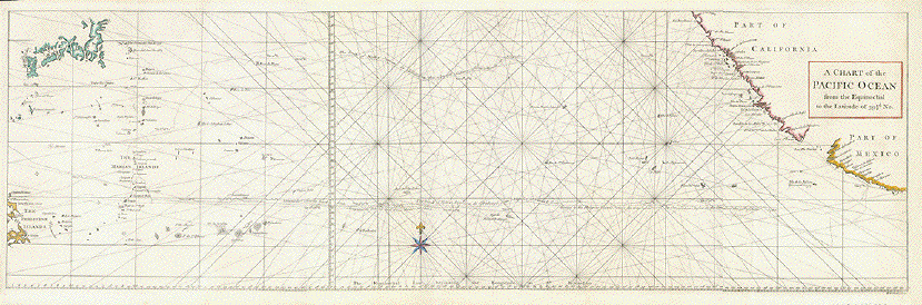
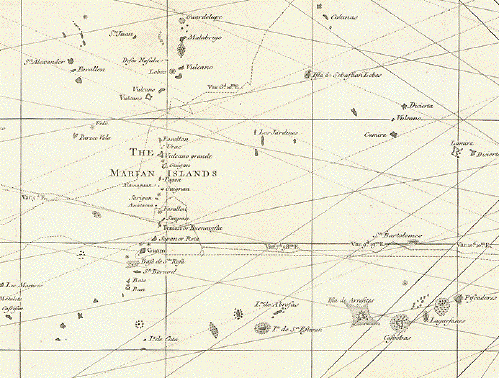
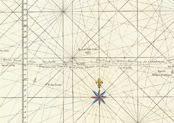
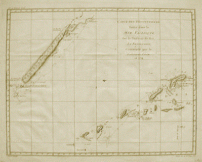
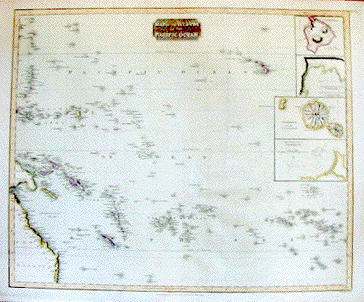
Islands of the Pacific

Take a look at this selection of antique maps of the Pacific Islands.

Ordering and Payment


"Samoa oder Schiffer-Inseln". Wood engraving printed in color from the Bibliographisches Institut in Leipzig, ca 1880.

Map shows the islands Savaii, Upolu, Tituila and Tau. In the upper right corner is a detail of the harbor and town of Apia on the island of Upolu. In the lower left is a detail of the insel showing settlements and topography.

Map is in Very Good condition.

12 x 20.5 cm ( 4.7 x 8 ")

$65.00

Order Nr. SOUTH PACIFIC 2512


"Die Fidschi-Inseln" Wood engraving from Spamer ca 1875.

This map is on a page of text (in German which has part of an article about the Fiji Islands. On the reverse side of the map is an image of Fiji Island inhabitants with painted faces.

10.2 x 17.1 cm ( 4 x 6.7 ")

$ 60.00

Order Nr. PACIFICISLANDS2521


"Der Grosse Ocean und Australien 1849." Steel etching from "Neuester Zeitungs Atlas. Alter und Neuer Erdkunde" by J. Meyer, ca 1855. Some original outline coloring.

Map shows the wide area of the Pacific Ocean, Australis and the bordering countries.

Except for some very minor spotting in margins, the map is in Almost Very Good condition.

21.1 x 26 cm ( 8.3 x 10.2 ")

$ 90.00

Order Nr. AUSTRALIA2306


"Carte de L'Océanie dresée et dessinée Sous la Direction de Mr. J.G. Barbie du Bocage". Steel engraving by Ch. Smith published in Paris by Maison Bassett ca 1850. Modern hand coloring.

A detailed and decorative map showing the southern Pacific and Asian region.

Except for some very minor spotting in margins, the map is in Very Good condition.

22.4 x 30.5 cm ( 8.8 x 12 ")

$ 320.00

Order Nr. PACIFIC2298


"Carte des Découvertes faites dans la Mer Pacifique fur le Vaiseau de Roi, La Resolution, Commandé par le Capitaine Cook en 1774" Copper engraving under the direction of Benard published ca 1780.

In the upper left is New Caledonia. In the lower right are the New Hebrides. Dotted lines show the route followed by Captain Cook around and between the islands.

Map has several folds to fit book size. Light browning on margin edges.

35.7 x 46.2 cm ( 14 x 18.1 ")

$ 600.00

Order Nr. SOUTHPACIFIC2515


"Australien und Polynesien" Steel engraving by W. Alt after Herm. Berghaus, ca 1850. Original outline coloring.

Fine map with the entire Pacific region. In the lower right is an inset of southeast Australia and Tasmania. In the lower left are conical forms representing the highest mountains of the area. These rage the Mauna Kea to Ualan.

Map has some minimal rubbing in upper left corner. A few islands have been underlined in light blue. Very clean. Very tiny crease in lower left margin corner.

19.8 x 25.7 cm ( 7.8 x 10.1 ")

$ 120.00

Order Nr. AUSTRALIA2316


"Australische Inseln" Wood engraving printed in color by the Bibliographisches Institut in Leipzig, 1882.

Very detailed map with major shipping routes. To the right of the title is a map of Germany for size comparison.

The map has vertical folds to fit atlas size. Small repaired tears in margins.

20.7 x 42.5 cm ( 8.1 x 16.7 ")

$ 90.00

Order Nr. AUSTRALIA2315


"Micronesia" Wood engraving by L.H. Gulick, printed in New York ca 1860.

At the top are the Ladrone Islands. The Marshall and Kings Mills Islands are in the lower right. The Caroline Islands are in the center and part of Melanesia is in the lower left.

10.3 x 20.5 cm ( 4 x 8 ")

On the backside is the following image:

7.5 x 12.5 cm ( 2.9 x 4.9 ")

$ 75.00

Order Nr. SOUTHPACIFIC2521


"Map of the Islands of the Pacific Ocean" Copper engraving by Neele for "Thomson's New General Atlas" published 1817. Original hand coloring.

For orientation, part of Australia is in the lower left corner and the Hawaiian Islands are in the upper right corner. In the upper right corner are four detailed insets. At the top is the island of Hawaii with a detail of Karakakoo Bay below. The third detail is Tahaiti and the fourth is Matavia Bay on the Island of Tahiti. In the lower right are the Society Islands. In the upper left are the islands of Guadalup, San Juan and St. Anthony.

Some parallel creasing to right of centerfold.Small repair to right of centerfold. Light browning in margins. Overall light age toning.

50 x 60.3 cm ( 19.7 x 23.7 ")

$ 690.00

Order Nr. SOUTHPACIFIC2516


Hawaii

"Carte des Isles Sandwich". Copper engraving by Bernard for Captain Cook's travel report, 1785. This map is from the first French edition.

Even though this map was done shortly after the European discovery of the Hawaiian Islands, one can see that the islands are in their correct geographical location. In the upper left (with the spelling of that time) are the islands of Atooi, Tahoora and Oneeheow. Further towards the middle of the map is Woahoo, then Ranai, Mowee and Tahoorowa. In the lower right is the large island, Owhyhee. The major volcanos on this island are shown in topographical detail. In the lower left is an inset of the "Bay of Karakakooa" (now spelled "Kealakekua"). The inset carries the date 1779. This inset shows fine details like fields, houses and the cliffs along the coast. The lines around and between the islands show the route of Captain Cook.

The print has the original horizontal and two vertical folds to fit book size. The left fold has the original reinforcement on the backside. Not visible on the frontside. There are a few minimal scattered spots.

27.4 x 45.8 cm (10.7 x 18 ")

$ 430.00

Order Nr. PACIFIC2520SOLD


"Vue Des Isles Sandwich" Copper engraving by Bernard for Captain Cook's travel report, 1785. This map is from the first French edition.

This map shows some topographical detail of the Hawaiian Islands. In the upper left is Mowee and in the upper right is Owhyee. The next row shows the islands of Atooi and Woahoo. Of special topographical interest is the next view of Atooi with the Colline a Pic to the right of the island. The lower image shows a view of the western coast of Oneehow. Those knowledgeable in Hawaiian history will recognize these names.

Map has two original vertical folds to fit book size. The left fold has reinforcement on the backside. Not visible on the frontside. Small repaired hole on fold line. Light crease in upper right margin corner.

18.8 x 39 cm ( 7.4 x 15.3 ")

$ 320.00

Order Nr. PACIFIC SOLD


Plan des Havres qu'on trouve au Côté N. D'Eimeo. Copper engraving by Bernard for Captain Cook's travel report, 1785. This map is from the first French edition.

Very detailed topographical map of the harbors on the north coast of Eimeo. On the left is the harbor of Avorate and on the right is the harbor of Tatoo. The coastal banks are shown as well as the depth of water at various lacations.

Map has one original horizontal fold in the lower area. Minor browning in margins.

19 x 22 cm ( 7.4 x 8.6 ")

$170.00

Order Nr. PACIFIC2518


"I. Wenooa Ette, I. Wateeoo, Isle Mangeea, Isle Toobouai". Copper engraving by Bernard for Captain Cook's travel report, 1785. This map is from the first French edition.

Map shows the four islands given above. The latitude and longitude of each island is given.

Map has a repaired tear in lower right. Right margin is narrower.

22 x 17 cm ( 8.6 x 6.6 ")

$ 220.00

Order Nr. PACIFIC2517


"Australien" Steel engraving by C.F. Weiland in Weimar, dated 1840. original hand coloring.

Detailed map with part of China and Japan in the upper left corner and part of Mexico and California in the upper right corner. In the lower right corner is a detailed inset of New South Wales.

Map has overall light age toning and a some light scattered spots. Light creases in left margin.

27.8 x 39 cm ( 10.9 x 15.3 ")

$ 450.00

Order Nr. AUSTRALIA2309


"Australien (Suedland) auch Polynesian oder Inselwelt, insgemein der Fuenfte Welttheil genannt". Copper engraving by Johannes Walch in Augsburg, dated 1802. Original hand coloring.

Map shows part of China and Japan, Southeastern Asia, Australia, New Zealand and the South Pacific. In the upper right to the left of the title cartouche are the Hawaiian Islands. On the right are the Marquesas and Society Islands.

Map has overall light age toning and browning along margin edges. Vertical centerfold with a few light parallel creases. Some creasing and a few spots in margins.

47.4 x 60 cm ( 18.6 x 23.6 ")

$ 690.00

Order Nr. AUSTRALIA2312


"Mittelamerica Mit den Specialkarten Ueber Die Vulkanreihe von Guatemala, Die Landengen von Tehuantepec, Nicaragua und Panama, und Die Central Vulkane Der Suedsee." Steel etching from "Neuster Zeitungs Atlas. Alter und Neuer Erdkunde" by J. Meyer, ca 1855. Some original outline coloring.

This very interesting map feautures the volcanic mountain chain of Central America and the South Pacific Islands. In southern Mexico and throught Central America are lines showing the volcanic areas. Three graphs show the topographic situation of Panama, Costa rica and Guatemala. In the upper right are two very detailed insets, the smaller of Nicaragua and the longer one of the Istmus of Panama. On the left ia a large inset showing the Istmus of Tehuantepec in careful detail. In the lower left corner is an inset of the Galapagos Islands. The next shows the Hawaiian Islands with a special graph showing the comparative heights of the volcanos. The very small middle inset show the Mendañas Archipelago. The next group of islands is the Society Islands (Tahiti) and in the lower right are the Friendship Islands, (Togo, Late, Hapai, Kotu....).

Map a a bit of light browning on margin edges. Condition is otherwise Almost Very Good.

21.7 x 27.5 cm ( 8.5 x 10.8 ")

$ 110.00

Order Nr. CENTRALAMERICA2005


"Les Isles Philippines, Celle de Formose, Le Sud de La Chine, Les Royaumes de Tunkin, de Cochinchine, de Camboge, de Siam des Laos...." Copper etching by Rigobert Bonne (1729-1795) for "Atlas de toutes les parties connues du globe terrestre" by Guillaume Thomas Francois Raynal (1713-1796). Published 1780 in Geneva.

This map of Southeast Asia is full of interesting details. In the west is part of Burma (Kingdom of Pegu) and and the Gulf of Martaban. Further south is part of Malayasia with the towns Keda and Patan shown. Taiwan is shown in the northeast. The small inset in the upper right is Guam. The long narrow inset in the upper right shows the Mariana Islands with Guam at the bottom. In the southeast are the Philippines. In the very south are the Sulu Islands and the northern part of Borneo. West of the Philippes are arrows showing the directions of the wind at various times of the year. Some of the underwater banks are shown as dotted circles in several places.

Map has light toning on centerfold and light browning on upper and right edges. Minimal creasing in lower right margin. Condition is otherwise Very Good.

20.9 x 31.6 cm ( 8.2 x 12.4 ")

$ 280.00

Order Nr. SOUTHEASTASIA2506


"Les Isles Philippines, Celle de Formose, Le Sud de La Chine, Les Royaumes de Tunkin, de Cochinchine, de Camboge, de Siam des Laos...." Copper etching by Rigobert Bonne (1729-1795) for "Atlas de toutes les parties connues du globe terrestre" by Guillaume Thomas Francois Raynal (1713-1796). Published 1780 in Geneva. Modern hand coloring.

This is the same map as above, but with hand coloring. This map of Southeast Asia is full of interesting details. In the west is part of Burma (Kingdom of Pegu) and and the Gulf of Martaban. Further south is part of Malayasia with the towns Keda and Patan shown. Taiwan is shown in the northeast. The small inset in the upper right is Guam. The long narrow inset in the upper right shows the Mariana Islands with Guam at the bottom. In the southeast are the Philippines. In the very south are the Sulu Islands and the northern part of Borneo. West of the Philippes are arrows showing the directions of the wind at various times of the year. Some of the underwater banks are shown as dotted circles in several places.

Map has overall light age toning and a slight bit of offsetting in the margins. Otherwise the condition is Very Good.

Ca 21x 31.6 cm ( 8.2 x 12.4 ")

$ 290.00

Order Nr. SOUTHEASTASIA 1761


"Océanie". Steel engraving by Laguillermie for C.V. Monin, ca 1850. Original outline coloring.

This map shows the various divisions of Oceania. In the lower right corner is an inset showing part of the eastern coast of Australia. Sydney is in the midlle of the coastline. At the bottom of the inset is the Muroo River. At the top is Cape Smokey and the Cockburn River.

Map has vertical centerfold. Tiny repaired tears on lower margin edge. Spotting on lower right margin edge.

28 x 39.5 cm ( 11 x 15.5 ")

$290.00

Order Nr. AUSTRALIA2307


"Plan du Harvre de Tongataboo, 1777.". Copper etching by Benard, ca 1780.

Map shows the harbor of Tongataboo with some of the surrounding islands such as Hoolaiva, Attataa, Holoa and Eooaigee.

Map has vertical folds to fit book size. Left and right margins have been widened. A few trivial spots.

$ 190.00

Order Nr. SOUTH PACIFIC 2513


"Carte des Isles des Amis". Copper etching by Benard, ca 1780.

This map shows the islands that belong ton Tonga. It is west-oreiented which means north is on the left side. Dotted lines with the date 1775 show the"Route de la Resolution". Some islands have older forms of names.

Small crease on left side of map. Tiny crease in left margin. A bit of light smudging. General condition is Much Better than Good.

24 x 34.4 cm ( 9.4 x 13.5 ")

$ 190.00

Order Nr. SOUTH PACIFIC2508


" Carte de l'Hemisphere Austral". Copper etching by Benard. Published in "Voyages de Cook", Tome I ca. 1780. Original hand coloring.

The South Pole is the center of this southern map of the world. The vertical line in the center is the Greenwich Meridian, In the lower left is the southern part of Africa. In the lower right is the southern part of South america with Brazil colored green. In the upper left is Australia and part of southeast Asia. The exploration routes of Captain Cook are shown. In all the corners are the names of newly explored islands and newly founded settlements with degrees of longitude and latitude.

The map has several fold to fit book size. Overall light toning. Condition is Almost Very Good.

53.4 x 53.4 cm (21 x 21 ")

$ 1300.00

Order Nr. POLAR2169


"A Chart of the Pacific Ocean from the Equinocitial to the Latitude of 39.5 d. No." Copper engraving by R.W. Seale in London in 1750. Original hand coloring.


This sea chart shows the historical routes of the Spanish galleons beteen Acapulco and the Philippines. Dotted lines show the routes taken as well as historical events that happened along the way. In the upper right is the coast of California reaching as far north as Punta de los Reyes and Los Farollones. Further south is part of mexico reaching as far south as Acapulco. In the upper left is part of Japan and in the lower left part of the Philippines.

Map has various folds to fit atlas size. Some scattered spotting and staining. Small repair on lower right margin corner. Coloring is somewhat lighter than shown on map.

27.5 x 88 cm ( 10.8 x 34.6 ")

$ 930.00

Order Nr. SOUTHPACIFIC2514


"Australien" Steel engraving by C.F. Weiland in Weimar. Published in the Geograph. Institut in 1846. Original hand outline coloring.

Map show Australia and New Zeland and the many islands of the South Pacific. In the upper left corner is part of China and Japan. In the upper right corner is part of the coast of California and northern Mexico. In the lower left is a detailed inset of the southwest of Australia. In the lower right are two detailed insets; on the left inset is New south Wales and in the lower right corner is Van Diemens Land (Tasmania).

Map has wide margins and a vertical centerfold. A few light, parallel creases near centerfold. Minor scattered spots in map and light spotting and browning in margins. Two tiny repaired tears on lower margin edge.

44 x 62.2 cm ( 17.3 x 24.4 ")

$ 530.00

Order Nr. AUSTRALIA2311


"Australien" Steel engraving by W. Kratz, C. Poppey and C. Graf, 1857. Original outline coloring.

Map shows Australia, New Zeland, part of China, Japan and Southeast Asia. In the upper right is a bit of the California coast by San Francisco. At the bottom of the map are detailed insets. In the lower right corner is an inset of Tahiti. Under it is one of the Hawaiian islands. To the left is New Zealand. In the lower left corner are insets of the australian coast from Bateman Bay to Clarence in the north. Sydney is on the middle of the coastal detail. The other inset shows Tasmania.

Map has vertical centerfold with a few light parallel folds near center. Small repaired tear in lower margin edge on centerfold. Outline coloring is a bit lighter than on the image above. Overall light toning.

52.5 x 65 cm ( 20.6 x 25.5 ")

$ 520.00

Order Nr. AUSTRALIA2310


"Australien". Copper etching from a German source ca 1800. Original hand outline coloring.

Interesting map of Australia, New Zealand, Southeast Asia and the South Pacific. In the upper left is a bit of mainland China and in the upper right a tiny corner of California with San Diego. On the right edge are the Easter Islands and at the lower center are Campbells and Macquarries Islands.

Map has wide margins and hardly any spotting. Repair on lower margin and two tiny repairs in image that are only visible from the backside. Condition is otherwise Better than Good.

29.2 x 39 cm ( 11.4 x 15.3 ")

$ 375.00

Order Nr. AUSTRALIA2304


"Carte de l'Archipel de St. Lazare ou Les Isles Mariañes". Copper etching by Bellin after a map from P. Alonso Lopez, a Spanish Jesuit missionary to the islands. Ca. 1750. Attractive modern coloring.

The map shows the group os islands known as the Marianas. In the north is the island of Urac, known then as Isle Deserte. South of Urac is the island then called Maug or Tunas and to the south of that is Assonsong, known today as Asunción. In the far south is Guahan or Guan, also known as the isle of St. Jean and today as Guam. The inset in the lower left corner is a detailed map of Guam. Very interesting are the names of settlements on Guam at the time.

Except for a two small worm holes in the margin, the map is in Excellent condition.

22.5 x 15.5 cm ( 8.9 x 6.1 ")

$ 250.00

Order Nr. PACIFIC2501


"Southern Hemisphere Projected on the Plane of the Horizon of London". Copper etching by J. & G. Menzies after Geo. Buchanan for "Thomson's New General Atlas", published in 1816. Original hand coloring.

This very interesting map shows the southern hemisphere with the South Pole shown in sketchy form. Notice Australia and Southeastern Asia on the upper left side. In the upper right part of the map are the Sandwich Islands (Hawaiian Islands). On the lower right is the southern part of South America. Lines show the various exploration routes of early explorers.

Map has browning on left margin, especially in the upper and lower corners. Horizontal centerfold. Lower margin edge is a bit frayed on right side. In upper margin is a light brown line.General condition is Better than Good.

Page size: 61 x 53.5 cm ( 24 x 21 ")

Diameter of map: 50 cm ( 19.6 ")

$ 400.00

Order Nr. AUSTRSLIA2302


"Carta Delle Scoperte fatt nel Mar Pacifico sopra il Vassello la Resolution Comandata dal Capitano Cook nel 1774". Copper etching from an Italian atlas, ca 1780.

Map shows New Caledonia in the Upper left and the New Hebrides in the lower right. The map is west oriented so that north is on the right side. The names of the islands are early names, some of which have changed over the years. There are dotted lines around the islands showing the exploration route of Captain Cook.

Map has folds to fit book size. Lower right margin corner has been repaired. Overall condition is Better than Good.

18.3 x 23.3 cm ( 7.2 x 9.1 ")

$ 240.00

Order Nr. SOUTH PACIFIC 2509


"Ost-Polynesien" Steel etching by C. Poppey after W. Berghaus for "Stieler's Hand Atlas" . Published in Gotha 1854. Original hand outline coloring.

This map of estern Polynesia shows part of the Hawaiian Islands in the upper left corner. In the lower left corner is Tahiti and Nuka Hiwa. In the upper right corner is a detail of Mauna Loa volcano and a bit of coastline of the Island of Hawaii. In the lower right corner is a detail of Honolulu, Tahiti and Floriana Island. The diagonal lines are the exploration routes of early German explorers.

Map has vertical centerfold, light browning on margin edges and very minimal spotting in margins. Condition is Much Better than Good.

33.5 x 41 cm ( 13.1 x 16.1 ")

$ 380.00

Order Nr. SOUTH PACIFIC 2510


"West-Polynesien" Steel etching by C. Poppey after W. Berghaus for "Stieler's Hand Atlas". Published in Gotha 1854. Original hand outline coloring.

This map of western Polynesia shows Australiaa and New Guinea in the lower left corner. There are two detailed insets showing the island of Witi Lewu and Tongabatu. In the lower right are Tonga and the Fidji Islands.

Map has vertical centerfold, light browning on margin edges and very minimal spotting in margins. Condition is Much Better than Good.

33.5 x 41 cm ( 13.1 x 16.1 ")

$ 380.00

Order Nr. SOUTH PACIFIC 2511


Papetee

Wood engraving. Ca 1870. Print has text on backside which shows faintly in margins.

9.5 x 16 cm ( 3.7 x 6.3 ")

$ 40.00

Order Nr. South Pacific 2507


"L'Oceania divisa nelle Quattro Sue Magne Part 1844". Lithograph from an Italian source, ca 1850. Original hand coloring.

It is easy to see the large area encompassed on this map of Oceania. In the upper left is part of China and Japan. In the upper right is paer of North America.

Map has wide margins with some light creases in margins, especially on edges. There is a spot on the map image in the norther part of Japan. S few very light scattered spots in margins.

21.5 x 32 cm ( 8.4 x 12.6 ")

$280.00

Order Nr. AUSTRALIA2308

Prints of the South Pacific

Maps of the World

Ordering and Payment

E-mail

Terms of Sale - Lieferbedingungen

Home Page