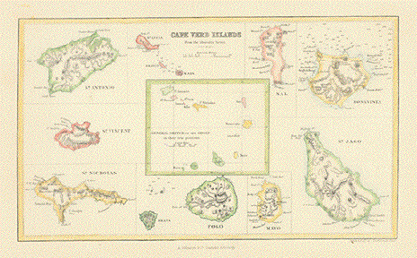
Antique Maps and Prints of the Cape Verde Islands

Ordering and Payment

Lieferbedingungen

Sale! Discount!

30% Discount on All maps with a CAPEVERDE number on this page!

Take 30% off the listed price. !

"Cape Verd Islands"

Map of the archipelago, in the center of map as a whole, surrounded by larger views of the various islands.

Very pleasantly hand-colored steel engraving, done for the Admiralty Survey.

London & Edinbourgh, ca. 1850 Repaired tear in lower margin and into light yellow border.

13,7 x 23,3 cm (ca. 5.4 x 9.2")

$ 160.00

Order Nr. CAPEVERDEISLANDS248317


"Praya Bay, in the Island of St. Iago"

Hand-colored copper etching by Torry

Published by Robert Laurie and James Whittle. after Jean-Baptiste Nicolas.

London, 1782

18,3 x 22,3 cm (ca. 7.2 x 8.8")

$ 130.00

Order Nr. CAPEVERDEISLANDS248318


"Habit des Negres du Cap Verd"

Hand-colored copper etching by Chedel after the drawing by Cochin.

From a French travel book. Paris, ca. 1800

12 x 7 cm (ca. 4.7 x 2.8 ")

$ 70.00

Order Nr. CAPEVERDEISLANDS248315


"Aiguade de la Praya a Sant-Yago ( Isle du Cap Vert.)"

Water fountain on the island of Santiago.

Hand-colored steel engraving from: "Voyage fait par ordre du roi en 1768 et 1769"

Paris, ca. 1830

10,2 x 16 cm (ca. 4 x 6.3")

$ 90.00

Order Nr. CAPEVERDEISLANDS 248316


Cape Verde Islands

"Leute von den Kapverden" ( People from the Cape Verde Islands"

Wood engraving published 1904. Reverse side is printed.

7.5 x 6 cm ( 2.9 x 2.3 ")

$ 30.00

Order Nr. CAPEVERDE248046


"Mittel - und Nord-Africa. Westl. Theil"

Steel engraving by F. von Stuelpnagel. Published 1871 by Stieler. Original outline hand coloring.

Detailed map with outline coloring showing the colonial possesions of various European countries at the time. On the far left are the Cape Verde Islands. At the bottom of the map is a diagram showing the mountain heights from Tripoli to the Tschad Lake from an exploration trip by E. Vogel in 1853. In the upper left is a height profil of the Sahara from Tripoli to Bagzen by the exploration trip of Richardson, Barth and Overweg.

Map is in good condition. Vertical centerfold.

32 x 38 cm ( 12.5 x 14.9 ")

$ 135.00

Order Nr. NORTHAFRICA237979


"Partie Occidentale d'Afrique ou se trouvent les Isles des Canaries et du Cap Verd dans la Mer
Atlantique des Etats du Roy de Maroc, les Royaumes d'Alger et de Tunis le Biledulgerit et 
le Saara, en Barbarie, La Nigritie, et la Guinee"

North-west Africa with the archpelagos of the Canary Islands and of the Cape Verde Islands.
The Tropic of Cancer running right through this map.

Copper etching with original borderline hand coloring by Nicolas de Fer (1646-1720)

Published in "Petit et nouveau atlas". Paris, 

Very nice colors. Minimal traces of age and use. Good condition.
Old and-written page number in upper rght corner.

Map image: 22 x 32 cm (ca. 8.7 x 12.6")

$190.00

Order Nr. AFRICAMAP249982 


Antique Prints of Portugal

Ordering and Payment

Maps of the World

E-mail

Terms of Sale - Lieferbedingungen

Home Page

Impressum

Datenschutz

©Rainer Rauhut