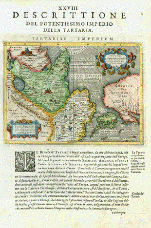
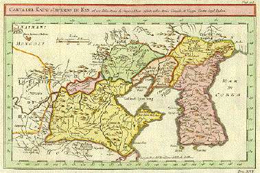
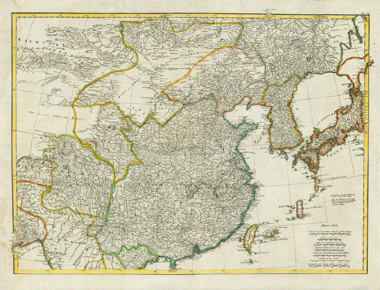
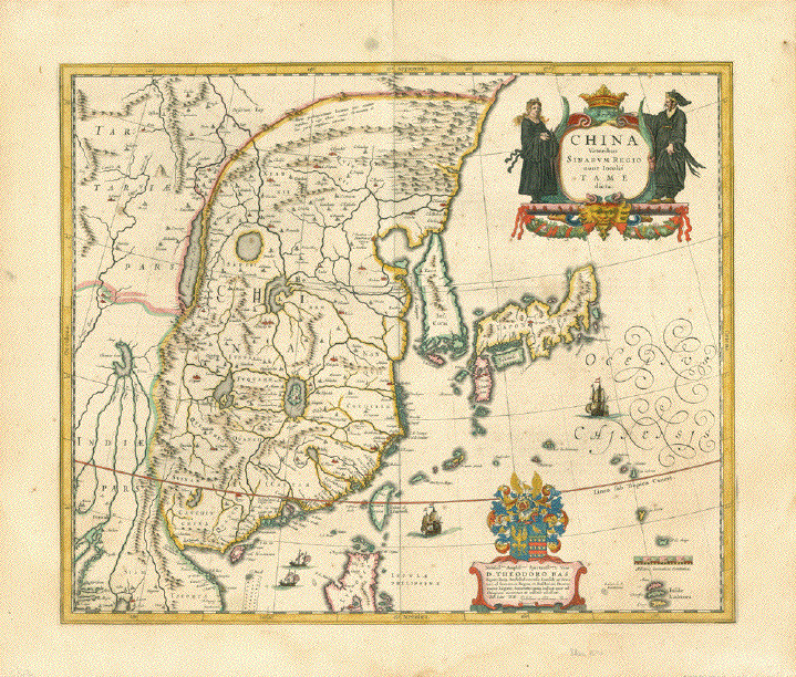
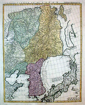
Antique Maps of Japan, Korea and Northeast Asia

This is a selection of our available maps. Please ask us for maps you may be searching for.

Ordering and Payment

Lieferbedingungen

Sale! Discount!

30% Discount on All maps with a JAPANMAP number on this page!

Take 30% off the listed price. !

Visit us at the following sites:

https://lovelyantiqueprints.com

twitter.com/philographikon2

"Descrittione del Potentissimo Imperio della Tartaria - Tartariae Imperium". Plate XXVIII (28)

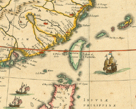
This map shows suggestively in outlines the West Coast of North America from what later became Alaska, British Columbia, Washington (State), Oregon and California (which was already named). It also shows Japan, China, Russia, Mongolia, Central Asia.

Type of print: Copper etching

Artist: Girolamo Porro

Published in: "Geografia cioe Descrittione Universale della Terra"

Publisher: Gio. Battista & Giorgio Galignani Fratelli

First published in: "Geographia" von Claudius Ptolemy

Edition: Italian edition

Editor: Giovanni Antonio Magini (1555-1617)

Text: Italian. Complete on front and reverse side

Published in: Venice

Date: 1598

Measurements:

Map size: Ca. 12,5 x 17 cm (ca. 4.9 x 6.7")

Page size: Ca. 28,5 x 19 cm (ca. 11.2 x 7.5")

Condition: Near perfect. Left margin a bit narrow. Very minor traces of age.

$480.00

Order Nr. ASIAMAP236461


"Chinesisches Reich und Japan"

Lithogaph after F. Handtke, ca 1850. Original outline coloring.

Map shows topography and the major cities and settlements of the time.
Japan, Formosa, Korea and Hainan are on the right side of the map.

Fine, clean map image. Minor signs of age and use in margins.

Map image: 30.5 x 39 cm ( 12 x 15.3 ")

$ 75.00

Order Nr. CHINAMAP242110


China (Oestl. Theil), Korea, und Japan

Steel engraving by H. Eberhardt, Terrain and Jungmann and worked on by Erst Debes for Stieler. Dated 1871. Original outline coloring.

In the lower right corner are insets showing detailed plans of Shanghai, Jedo (Tokyo) and Canton and surrounding area. The outline colors designate political boundaries according to the color key at the bottom of the map.

Map is in good condition. Vertical centerfold.

33.5 x 40 cm ( 13.1 x 15.7 ")

$ 125.00

Order Nr. JAPANMAP235815


"Carta del Katy o Imperio di Kin ad uso della Storia di Jenghiz Khan riferita nella Storia Generale de'Viaggi. Tratta dagl'Inglesi.". Copper etching in modern coloring. Italian, anonymous. Ca. 1850.

This interesting map shows the northern part of China which includes the provinces of Shantung, Hopei, Liaoning Kirin and Manchuria. In the north and northwest is Mongolia. At left center begins the Great Wall of China. All of Korea is shown with many of its former names. The map has many topographical details such as the riversytems and mountains.

The map has 3 vertical and 3 horizontal folds to fit atlas size that are almost invisible. Light overall toning. Condition is Very Good.

20 x 30.7 cm (7.9 x 12.1 ")

$ 450.00

Order Nr. JAPANASIA MAP 1740


No Title

Map of China that also shows part of Japan, Tartary, Taiwan, Gobi Desert and Korea.

Copper etching after J. B. D'Anville by F.A. Schraembl and engraver Iacob Adam.

Published in Vienna 1786.

Coloured by hand at a later date. Strong paper. Vertical centerfold has been flattened.
Map was once mounted and has rest glue on reverse side. Some light creasing.

This is the upper part of a 2-part map of Asia.

Map image: 49 x 68 cm (19.2 x 26.7 ")

$ 680.00

Order Nr. CHINAMAP250722


" Carte de Découvertes en 1787 dans les Mer De Chine et de Tartarie....". Copper etching by Bouclet from " Atlas du Voyage de la Pérouse" (# 39). Ca. 1800. Recent hand coloring.

This map shows a smaller area and more details than the previous map. It reaches from Manila in the Philippines to Osaka in Japan.

The map has wide margins. In the lower margin corners are water stains. General condition is Almost Excellent.

49.5 x 68.5 cm ( 19.5 x 27 ")

$ 1280.00

Order Nr. JAPANASIAMAP1743


"Vue de L'Isle de Soufre" Copper engraving by Bernard for Captain Cook's travel report, 1785. This map is from the first French edition.

Map shows the Isle de Soufre on the left side with the North island at the top and the South island at the bottom. At the top is a detail of the south part of the island. Dotted lines show the route of Captain Cook's voyage.

Map has fold to fit original book size. Minor spotting. Small piece of upper left margin is incomplete.

25.2 x 21 cm ( 9.9 x 8.2 ")

$ 70.00

Order Nr. JAPANMAP1472


"Chine et Japon"

Steel engraving by Th. Duvotenay, 1837.

Folds to fit original book size. Spot in lower right margin corner, otherwise very clean.

18 x 23 cm ( 7 x 9 ")

$ 35.00

Order Nr. CHINA242476


"China Veteribus Sinarum Regio nunc Incolis Tame dicta"

Copper etching by Willem Janzoon Blaeu (1571-1638)

Map of China, Korea, Japan, Taiwan, Northern part of the Island of Luzon (Philippines).

Original hand coloring.

Reverse side with explanatory text in French.

Published by Joan Blaeu

Amsterdam, 1634

Of Blaeu's set of maps of China the overall China map. Beautifully originally hand-colored.
A proud piece of map art. Title cartouche and coat of arms dedication to Theodor Bas.
Sailboats scattered on Pacific. A very attractive map.

Light and pleasant age toning. Some very minor traces of age and use in margins.
A little crease in lower margin. A few light spots in margins. Otherwise very minimal spotting.

41,5 x 50 cm (ca. 16.3 x 19.7")

$ 2600.00

Order Nr. CHINAMAP249016


"Partie du Japon ou Nipon". Copper engraving by Bernard for Captain Cook's travel report, 1785. This map is from the first French edition. At the top of the map is a tpographical detail with the title: "Vue de la Côte du Japan lorsque nous la vunes pou la 1ere fois la Colline A estant dans l'O a 3 Millea.

The map reaches from Point Nord and Cape Nambu at the top to Pte. blance and Pte Sanddown at the bottom. Dotted lines show the route of Captain Cook's voyage.

Map has two hardly visible folds to fit original books size.

Page size:30.5 x 24.5 cm ( 11.8 x 9.6 ")
Map size: 21.3 x 20.2 cm ( 8.3 x 7.9 ")

$ 140.00

Order Nr. JAPANASIAMAP1750


"Empire of Japan". Copper etching by Lowry drawn under the direction of M. Arrowsmith and published June 1, 1807 in London. Modern hand coloring.

Map shows Japan with its many islands and an outline of Korea. The vertical lines in Korea are scales for British miles and Japanese Leagues.

Map has some light browning and spotting in margins. Light browning along centerfold. Some minimal creasing on left side. General condition is Better than Good.

24.5 x 40 cm ( 9.6 x 15.7)

$ 420.00

Order Nr. JAPANASIAMAP1746


" A New and Accurate Map of the Empire of Japan. Laid down from the Memoirs of the Portuguese and Dutch.". Copper etching by Emanuel Bowen, ca 1750.

To make this map fit a normal map size, the cartographer squeezed Japan together a bit. The map reaches about to Sapporo on Hokaido in the north . In the upper left corner is an attractive Roccoco cartouche with a Japanese pair in the garland and a head above the map sending beams over the cartouche.

Map has overall light toning and zwei vertical folds to fit book size. On the lower margin is a crease and on the left margin edge is some fraying. General condition is Almost Very Good.

35.3 x 43.2 cm ( 13.9 x 17 ")

$ 1650.00

Order Nr. JAPANASIA MAP 1744


"Carta dell'Isole del Giappone e la Penisola di Corea con le Coste della China da Pekin sino a Canton". Copper etching by Bellin from the Italian edition of his atlas. Ca. 1750. Modern hand coloring.

The geographical area of this map is very clear with Japan, Korea and the coast of China from Peking in the north to Canton in the south. Formosa (Taiwan) is shown in green off the coast of China in the south. The red horizontal line near the bottom is the Tropic of Cancer.

Map has overall light toning and several vertical and horizontal folds to fit atlas. The margin has been widened in the lower right corner. Overall condition is Almost Very Good.

20.2 x 28 cm ( 7.9 11 ")

$ 500.00

Order Nr. JAPANASIA MAP 1741


No Title Map of Japan

Steel engraving ca 1850. Folds to fit original book size. Lower left corner extended.

22 x 20 cm ( 8.6 x 7.8 ")

$ 45.00

Order Nr JAPANMAP242146


"ParteDell´Oceano Orientale che contiene le Coste di Tunquin e della China Le isole del Giapone le Filippine Moluche." Copper etching by Bellin, dated 1746. Modern hand coloring.

This decorative maritime map has a windrose in the center reaching in the north to Japan and Korea, to Formosa and China in the northwest. To the southwest are the Philippines, Borneo, Sumatra, Java and smaller islands. Directly south are the Moluccas and in the southeast is New Guinea. To the right of the windrose are the Mariana Islands. One the right side is a scale of leagues from France and England.

Map is very clean. The lower left margin has been widenened where the map was bound in the atlas. Folds are hardly noticeable. General condition is Very Good - Almost Excellent.

28.2 x 29 cm ( 11.1 x 11.4 ")

$ 375.00

Order Nr. JAPANASIAMAP1745


"et des Rojaumes de Corée et de Iapan". Copper etching after Jean Baptiste d'Anville, ca 1735-1740. Modern hand coloring.

This map is one of a two-map East Asian map series and includes Japan, Korea and the eastern part of China with Sachalin Island. Peking is not on the map. The northern part of Japan is still "terra incognita" on this map and is shown only with outlines.

Map haswide margins and overall light toning. In the margins are a few scattered spots. In the left margin is a crease reaching almost the entire length. On the centerfold is a restored tear in upper and lower margins. At the bottom is a hardly visible, 10 cm. repaired tear. At the top margin edge are minor repaired tears. General condition is Better than Good.

49.9 x 39.8 cm ( 19.6 x 15.7 ")

$ 1100.00

Order Nr. JAPANASIAMAP1747


"Empire de la Chine, Rme de Corée et Isles Du Japon". Copper etching by Andre for Rigobert Bonne (1729-1795). Published about 1770. Modern hand coloring.

China, Korea and Japan are shown with there major towns and cities highlighted in red on this map.

Map has wider margins than shown. On upper right margin corner is a light water stain. One tiny hole visible against the light on image. A tiny brown spot than can hardly be seen on image.Very light browning on margin edges. Overall condition is Almost Very Good.

23.2 x 34.5 cm ( 9.1 x 13.6 ")

$ 345.00

Order Nr. CHINA MAP 1703


Views of Japan

Home Page

Maps of the World

Ordering and Payment

e-mail

Terms of Sale - Lieferbedingungen

Impressum

Datenschutz

© Rainer Rauhut