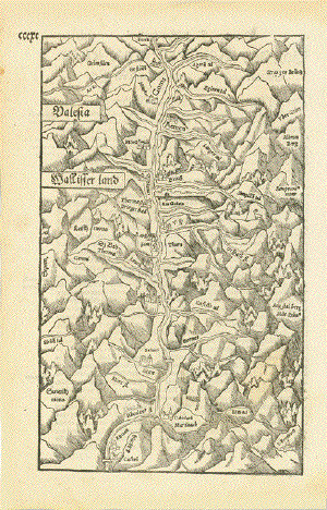
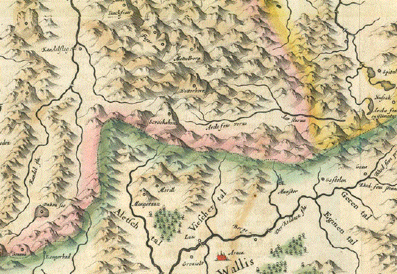
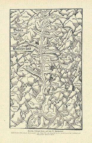
Antique Maps of Switzerland

View our selection of historical maps of Switzerland. All maps are in good condition unless otherwise noted.

Ordering and Payment

Lieferbedingungen

Sale! Discount!

30% Discount on All maps with a SWITZERLANDMAP number on this page!

Take 30% off the listed price. !

Visit us at the following sites:

https://lovelyantiqueprints.com

twitter.com/philographikon2


"Das Wiflispurger Gov"

Copper etching by Gerard Mercator (1512-1594)

Original hand coloring.

Published in the Mercator-Hondius Atlas

Amsterdam, 1607

Renaissance title cartouche

Verso: Text in Latin

The German name Wiflisburg is totally out of use in our time. The town is called Avenches in the Swiss Kanton Waadt (Vaud)

The map shows the south-west area of Switzerland. Basically the area between Bieler See - Neuburgersee (Lac de Neuchatel) - Murtensee - Thuner See and Lake Geneva (Genfer See - Lac Leman).

General age toning. Along north side of Thuner See oxidation of the green color has broken the paper (along the lake). This has been repaired. Occasional little repairs along margin edges.

36,2 x 48 cm (ca. 14.3 x 18.9")

$ 620.00

Order Nr. SWISSMAP252982


"Republique Helvetique divisee en ses 22 Cantons par F. Delamarche 1829"

Copper engraving made by F. Delamarche in 1829. The map was published in the atlas in 1832.

Orignal outline coloring. Map has vertical centerfold. Crease in lower right image.

26 x 38 cm ( 10.2 x 14.9 ")

Order Nr. SWISSMAP242281SOLD


"Savoy, Saubaudia". Copper etching by Hermann Moll, ca 1725. Published in London.

Map shows the region betwee Lake Geneva at the top of the map and the Mediterranean at the bottom On the upper right is Lago Maggiore and Lago d'Orta. On the left center is Grenoble. Backside has some text in English about Switzerland.

Map is not printed straight on the page. Light browning on margin edges and some spotting on lower margin. Lower left margin corner has creases. Condition is Almost Good.

Map image: 21 x 18.5 cm ( 8.2 x 7.2 ")
Page size: 32 x 21 cm ( 12.5 x 8.2 ")

$ 190.00

Order Nr. FRANCEMAP1172


"Das Wiflispur-Gerow"

Copper etching by Gerard Mercator (1512-1594)

Original hand coloring.

Published in the Mercator-Hondius Atlas

Amsterdam, 1607

Renaissance title cartouche

Verso: Text in Latin

The German name Wiflisburg is totally out of use in our time. The town is called Avenches in the Swiss Kanton Waadt (Vaud)

The map shows the south-west area of Switzerland. Basically the area between Bieler See - Neuburgersee (Lac de Neuchatel) - Murtensee - Thuner See and Lake Geneva (Genfer See - Lac Leman).

General age toning. Along north side of Thuner See oxidation on reverse side of the green color
has broken the paper (along the lake).
This has been repaired. Occasional little repairs along margin edges.

36,2 x 48 cm (ca. 14.3 x 18.9")

$ 820.00 (Please look for discount at top of this page. Here 30% = $ 574

Order Nr. SWITZERLANDMAP255163


"Die Eydtgnoschafft Puenten und Wallis. Helvetia cum Confiniis"

Copper by Hans Conrad Geiger (1599-1674)

At bottom center of map engraver's signature: Hans Conrad Geiger of Zuerich fecit 1637

Published by Matthaeus Merian in "Theatrum Europaeum"

Franfurt on the Main, 1734

Rare copper map etching of Switzerland. Decorative title cartouche. Upper right corner 33 coats of arms of cities, towns, Kantons.

Strong impression. Minor spotting. One worm hole upper left, outside map.

Part of the side margins have been cut away so that th upper part is wider than the lower part.

27,5 x 35,5 cm (ca. 10.8 x 14")

$ 380.00

Order Nr. SWITZERLANDMAP252987


"Switzerland"

Type of print: Lithograph

Color: Original hand coloring

Publisher: George W. Colton

Published in: "Colton's Atlas of the World illustrating physical and political geography"

Published: New York, 1856

Map includes all "Kantons" of Switzerland

Condition: Light general age toning. Very attractive, bright colors.

A decorative bordure frames this attractive map. Reverse side is blank.

32 x 39,5 cm (ca. 12.6 x 15.6")

Order Nr. SCHWEIZ 239546 SOLD


"Die Schweiz"

Lithograph by Handke after H. Mueller, 1848.

Original hand outline coloring. Shows the political divisions at the time.
Below the map are the elevations of the major mountains of Switzerland.

Minor repaired tears on upper margin edge. Light spotting in margins. A few signs of age and use.

Map image without the elevation list: 27 x 37.5 cm ( 10.8 x 14.7")
Page size: 36 x 44 cm ( 14,1 x 17.3")

$ 100.00

Order Nr. SWISSMAP254654


"Helvetiae descriptio". Copper etching Egidius Tschudi (1505-1572) for "Theatrum Orbis Terrarum" by Abraham Ortelius published in 1779. Fine hand coloring.

This map is south-oriented (south is at the top and north at the bottom). On the right is Lake Geneva and the Jura. . In the lower left is Lake Constance, the upper Inn valley and part of southwestern Germany. At the top are Lake Maggiore, Lake Lugano and Lake Como. In the upper left are more of the northern Italian Lakes. The many mountainous areas are shown.

Map has wide margins that have light browning and some light spotting. In the lower margin are two darker spots. In the map image are two hardly noticeable spots (more noticeable on the backside). Overall condition is Much Better than Good.

$ 720.00

Order Nr. SWISSMAP1530


"Argow cum parte merid. Zurichgow"

Partly hand-colored copper etching by Gerard Mercator

Published by Willem and Joan Blaeu

Amsterdam, 1635

Northern Switzerland with the lake district. Lakes on this map:

Zuerichsee

Walensee

Kldentalersee

Zuger See

Luzerner See

Vierwaldstätter See

Lungern See

Bringer See

Thuner See

The source of the River Rhein is also on this map. And Bern, the Swiss capital, is on the left edge of this map.

Clean map. Very good impression. Some minor traces of age and use in the far out margins. Verso: Explanitory text in the German language.

38,8 x 49,8 cm (ca. 15.3 x 19.6")

$ 450.00 MINUS 30% DISCOUNT = $ 315.00

Order Nr. CHMAP253027


"Argow cum parte merid. Zurichgow"

Original hand-colored copper etching by Gerard Mercator

Published by Willem and Joan Blaeu

Amsterdam, 1635. Verso: Explanitory text in the German language.
Vertical centerfold.

Northern Switzerland with the lake district. Lakes on this map:

Zuerichsee

Walensee

Kldentalersee

Zuger See

Luzerner See

Vierwaldstätter See

Lungern See

Bringer See

Thuner See

The source of the River Rhein is also on this map. And Bern, the Swiss capital, is on the left edge of this map.

Good condition. . Some minor traces of age and use in margins.
Small repair in lower margin on centerfold.

Map image: 38,8 x 49,8 cm (ca. 15.3 x 19.6")

$ 520.00 minus 30% Discount = $ 364.00

Order Nr. SWISSMAP255888


Wallis. - "Valesia - Wallisser land" Valais

Woodcut. Published in "Cosmographia" by Sebastian Muenster (1488-1552)

German edition.

Basel, 1553

Page has light natural age toning. Very good condition.

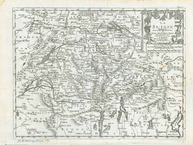
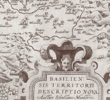
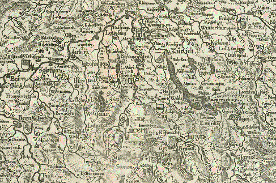
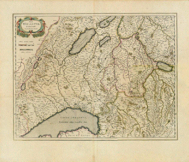
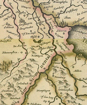
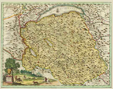
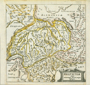
Like the spine of a person the River Rhone (here: Rhodan) is running through this vertical map of the Canton of Wallis from its source to just before it emties into Lake Geneva (Genfer See).

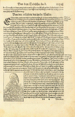
Reverse side: Article about the people of Wallis (the Walliser). This article is continued and completed
on the next page. This article is followed by an article about cities, towns and villages in the
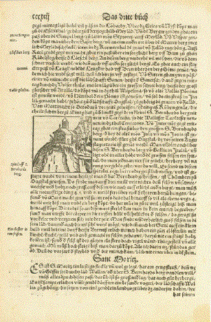
Wallis. A little woodcut of St. Bernard mountaintop chapel.

Articles which follow: Not all pages are shown. Those shown have woodcuts.

"Sant Moritz" (Saint Maurice VS)

"Von den Völkern des lands Wallis" (with a small woodcut of the legendary "big heads) of men and women

"Von oberkeit und Regiment des lands Wallis"

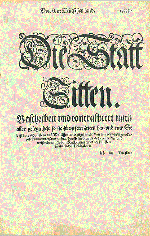
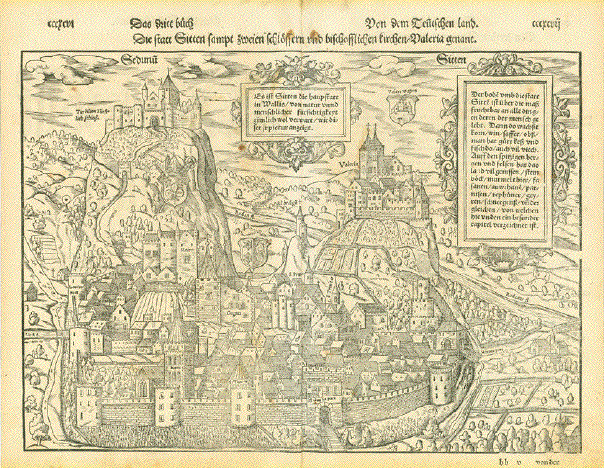
Followed by a beautiful double page view of the city of Sitten (Sion)

There is hardly any drawback of this beautiful woodcut worth mentioning. Except that there is an even pleasant age patina and very, very minor other traces of age.

Very good condition!

Image: 26,3 x 36,5 cm (ca. 10.4 x 14.3")

Followed on reverse side by article:

"Von der statt Sitten und anderen flecken des lands Wallis" (Sion)

Articles of the following pages:

"Sanct Moritz vor zeiten Agaunum"

"Martinacht oder Octodurum" (Martini)

"Gradetsch Alte Sider" (granges VS)

"Sider Leuck" (Bad Leuck)

"Raren Visp" (Raron Visp)

"Brig - Naters - Hieril" (Brigue)

"was bei den gletschern verstanden"

"Die Fruchtbarkeit des lands Wallis"

"Von wilden und seltzamen thieren unnd allerlei wildpraet so man in WallisÉ.findet"

"Von den Steinboecken und gemszen"

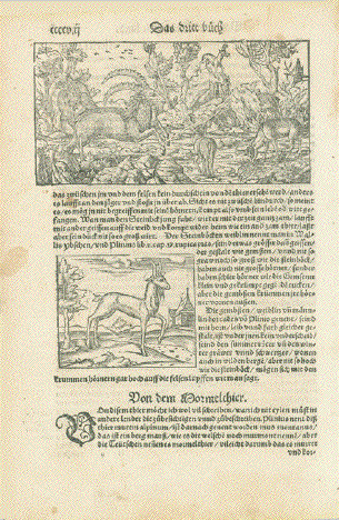
Followed by a woodcut with Alpine animals

8,3 x 16,3 cm (ca. 3.3 x 6.4")

and another woodcut showing a chamois

Next article:

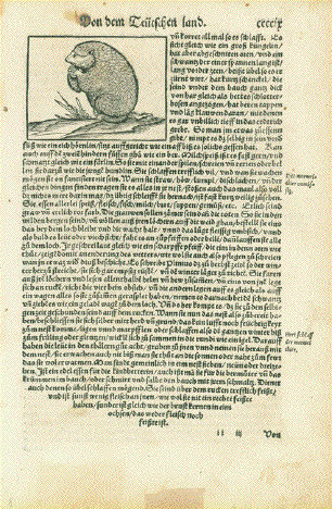
"Von den Mormelthier" (About marmots or groundhogs - with a woodcut of one such animal)

"Von Steinhuenern und Fasanen" (With a small woodcut of these birds)

This is the  coherent sequence of pages from "Cosmographia" by Sebastian Muenster, Basel, 1553
Not all pages are shown. Those shown have woodcuts.

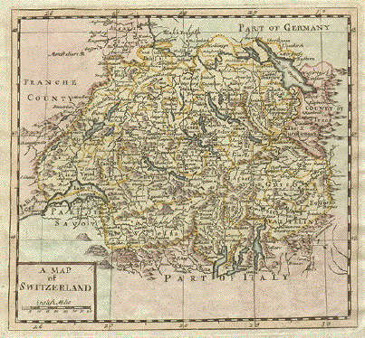
Consisting of map Wallis / Valais. Sitten / Sion double page general view several
small woodcuts as described and text articles and named by their book titles.

The lot has 8 pages. Text is in the German language. Not all pages are shown. Those shown have woodcuts.

The condition is generally Very Good for their age.. The map of the Rhone Valley in Wallis  and
the view of Sitten are in almost excellent condition considering how old they are..
There are some minor traces of age and use on some of the text pages.

Lot price is $ 1750.00 (Please look for discount at top of this page. Here 30% = $ 1225.00

Order Nr. SWITZERLAND MAP254518


No cartouche title. We find the title of this map printed across map: ãBurgundia Comitatus"

Reverse side of map: Language Latin. Title of map: Burgundia superior sive Liber Comitatus bulge La Franche Comte"

Area shown is Burgundy and the Kanton Waadt of Switzerland with Lake Geneva and Neubürger See (Lake Neuburg)

Original hand-colored copper etching by Gerard Mercator (1512-1594)

Published in the Hondius / Mercator atlas

Amsterdam, 1607 to 1612

The old color "green" has oxidized a small fraction on extreme right side.
The green oxidation is visible on the reverse side.
Repair has been done with China paper.. Extra fold parallel to centerfold.
Extra crease in lower area near centerfold.

Measurements:

Map 35,5, x 46 cm (ca. 14 x 18.1")

Sheet 44 x 53,8 cm (ca. 17.3 x 21.2")

$ 600.00 (Please look for discount at top of this page. Here 30% = $ 420.00)

Order Nr. FRANCE255153


"La Suisse suivant les Nouvelles Observations de Messrs. de l'Akademie
Royal des Sciences, etc...."

Copper engraving map by Pieter van der Aa (1659-1733) from "Ouresiphoites Helveticus, sive
itinera per Hevetiae Alpinas regiones" published 1723.

Almost in the center of the map is Zug On the left side is Lake Geneva
and on the right is Bormio. At the top of the map is the Black Forest and
Fuerstenberg. In the south is Biella in the Piemonte.

Map has several folds to fit original book size. Lower right margin has
been added. Repair in left margin on fold line. Lower margin widened.

Map image: 22 x 29 cm ( 8.6 x 11.2")

$ 250.00

Order Nr. SWISSMAP254486


"Potentissimae Helvetiorum Reipublicae Cantones Tredecim." Copper etching by Tobias Conrad Lotter ( (1717-1777) after Tobias Lobeck for the "Atlas Geographicus portabilis" (Pocket-size atlas) published 1760-1762. Original hand coloring.

Rotenbach and Thun are in the center of this fine little detailed map. In the upper right corner is Rottenstein and Kempten in Allgaeu. Part of Lake Garda is in the lower right and on the left is Lake Geneva and a bit of Savoy. In the upper left is Muhlhouse and Basel.

Map Is in Very Good condition.

9.3 x 12.2 cm ( 3.6 x 4.8 ")

$ 130.00

Order Nr. SWISSMAP1531


"Argow". Copper etching in very pleasant modern coloring. By Peter Kaerius (1571-1646). Amsterdam, ca 1620. Verso text in Latin.

This map shows the regio of Argau. About the title cartouche is the Rhine River. In the lower left is Leukerbad and Sana and in the upper left is Frauenbrunn and Bern. In the upper right is Walen Lake.

Upper margin has tiny repaired tears. The bottom margin has been reinforced to repair the tears on margin edge and lower left corner. Left edge has binding marks. One small wormhole in orange area lower left. The general condition is Better than Good for a map this age.

14.3 x 19 cm ( 5.6 x 7.4 ")

$ 145.00

Order Nr. SWISSMAP1529


*****

Reverse side:

"Basiliensis Territorii Descrptio Nova"

Copper engraving map by Ortelius after Sebastian Muenster.
Published ca 1580.

This is an east oriented map with Basel in the center. In the upper left
is part of the Black Forest with Freiburg.

The right and lower margins have been added. Some light creases in lower part
of map that have been flattened and hardly noticeable.
Very small hole to the left of the cartouche has been repaired.
Small thin spot in upper area has been repaired. Visible only on reverse side.

Map image: 32 x 24 cm ( 12.5 x 9.4")

$ 280.00

Order Nr. SWISSMAP254484


"NovaTotius Helvetiae cum suis Subditis ac Socius Tab. Geogr."

Copper engraving map by Matthaeus Seutter after Tobias Conrad Lotter.
Original hand coloring. Published in Augsburg 1760.
In the upper left is a vignette of the Rhine Falls and in the upper
right is a map showing the sourse of the Rhine. In the lower left are
the coats of arms of Switzerland and regions.

Map is printed on heavy paper with minor signs of age and use in margins.
The vignettes are somewhat light printing.

Map image: 19,5 x 25.5 cm ( 7.6 x 10")

$ 280.00

Order Nr. SWISSMAP254485


"Helvetiae Tabula"

Hand-colored woodcut

Published in "Cosmographia"

By Sebastian Muenster (1488-1552)

Basel, 1572

South-west oriented map of most of Switzerland, the German Black Forest and parts of Elasass in France. We see the River Rhein from its source via Lake Constance (Bodensee), Basel to Freiburg and Rheinau.

Map is the first of a triple map: Run of the River Rhein

Verso: Explanitory text in Latin language.

Light creasing in margins on centerfold. Crease in lower right margin.
Centerfold has been flattened. Condition is very good for a map this old.

25,5 x 34,4 cm (ca. 10 x 13.5")

$ 400.00

Order Nr. SWITZERLANDMAP252988


ãParte Orientale dell'Elvezia divisa Ne' Suoi Cantoni Di Nuova Projezione"

Eastern Switzerland from Lake Constance (Bodensee) soutz to Lago Maggiore and Lago di Lugano. Cantons shown: Schaffhausen, Zurich, Turgau. Appenzell, Zug, Thurgau, St. Gallen, Glarus, Schwyz, Uri, Graubuenden, Tessin (Ticino)

Type of print: Copper etching

Color: Original hand coloring

Publisher: Antonio Zatta (1757-1797)

Published in: Atlante Novissimo

Where: Venice

When: Dated 1781

Condition: Near excellent. only the faintest traces of age. Wide margins

Measurements: 41 x 31 cm (ca. 16.1 x 12.2")

Order Nr. SWITZERLANDMAP238504SOLD


ãDescrittione della Evetia. Helvetia" (Schweiz, Suisse, Switzerland)

Type of print: Copper etching

Artist: Girolamo Porro

Published in: ãGeografia cioe Descrittione Universale della Terra"

Publisher: Gio. Battista & Giorgio Galignani Fratelli

Edition: Italian edition

Editor: Giovanni Antonio Magini (1555-1617)

Text: Italian. Complete on front and reverse side

Published in: Venice. Date: 1598

Measurements:

Map size: Ca. 12,5 x 17 cm (ca. 4.9 x 6.7")

Page size: Ca. 28,5 x 19 cm (ca. 11.2 x 7.5")

Condition: Near perfect. Very minor traces of age.

Price: $ 240.00

Order Nr. SWISSMAP238496


"Sued-West Deutschland und Schweiz"

Steel engraving by H. Eberhardt und Wilh. Weiler for Stieler. Dated 1871.
Some original outline coloring.

Very detailed map with Luzern in the center. In the upper left is Chatel, Eseles and Darney in France. In the upper right the map extends as far as Ziementshausen and Krumbach in Swabia. Annecy and Albens are in the lower right corner. In the lower right corner is the northwestern corner of Lombardia with Bagotino and Pisogne in the corner area.

Map has minor spotting in lower margin. Small repair in lower margin on centerfold.

33 x 40 cm ( 12.9 x 15.7 ")

$ 65.00

Order Nr. SWISSMAP238243


"Sued - Westliches Deutschland und die Schweiz"

Steel engraving by C. Vogel for Stieler. Dated 1871.
Some original outline coloring.

Very detailed map showing the political divisions of the time. These divisions are named and described in the title inset in the lower right corner. The topography is emphasized on the map, especially the mountainous areas.

Map has a repair on the lower margin centerfold reaching 16 cm on centerfold. It does not disturb the overall impression.
Very minor wsigns of age and use in margins.

31 x 38.5 cm ( 12.2 x 15.1 ")

$ 65.00

Order Nr. DEUTSCHLANDMAP238367


ãSvizzera Italiana o Cantone Ticino" - ãTirolo Italiano". 2 steel engraved maps with original outline coloring by Pietro Allodi after Filippi Naymiller. Published in ãAtlante di Geografia Universale Cronologico, Storio, Statistico e Letterario". Milano at Francesco Pagnoni, 1870

Clean map with wide margins. One pinhead-size black spot within platemark, away from image. Otherwise excellent condition.

42 x 53 cm (16.5 x 20.9")

$ 250.00

Order Nr. ITALIAMAP1474


"Carta Geografica Del Ducato Di Savoja". Copper etching by J. Cassini de Thiery, ca 1750. Modern hand coloring.

Savoy is the theme of this map with the decorative hunting scene around the title. At the top is Lake Geneva in Switzerland. Above the tree is part of the Rhône river. At the middle of the right edge is Aosta. Susa is in the lower right.

Map image is very clean. Left margin has been widened. Folds to fit book size. Some spotting on right and lower magins. Light creases on lower margin edge. Condition is Much Better than Good.

32.7 x 42.2 cm ( 12.8 x 16.6 cm)

$ 250.00

Order Nr. FRANCEMAP1168


"A Map of Switzerland". Copper etching by Herman Moll ( 1678-1732). Published ca 1725. Modern hand coloring.

This map shows Swizerland with a bit of the northern Italian lake country as well as part of western Austria. Map image is on a complete page that has historical information about Switzerland below map image and continued on backside.

Margins are a bit frayed. Right margin is narrow. Creasing in upper margin reaching into image (hardly visible in image). Repaired tear on lower margin edge. General condition is Good.

Map image: 17.4 x 18.9 cm ( 6.8 x 7.4 ")
Page size: 31.5 x 20.1 cm ( 12.4 x 7.9 ")

$ 160.00

Order Nr. SWISSMAP1527

"Territory Basiliensis nova descriptio". Copper etching by Peter Kaerius and ed. by Johann Janssonius, Amsterdam, ca 1650. Original hand coloring.

Basel is right in the center of this 3-country region. In the upper left is part of Alsace and northern Burgundy. In the northeast, enclosed by the Rhine river, is the Black Forest of Germany. The lower part of the map is Switzerland. The course of the Rhine is from Waldshut in the east as far north as Breisach. Many topographical details.

Map has light natural age toning and a small spot in left margin. Small repaired tears in upper and lower margins on centerfold.
Minor montage rests in upper corners on reverse side. General condition is Almost Very Good.

Map image: 37.7 x 48.8 cm ( 14.8 x 19.2 ")

$ 640.00 minus 30% Discount = $ 448.00

Order Nr. SWISSMAP1525


"Die Schweiz"

Very detailed map of Switzerland with a city-town population key in the upper left. corner.
Published 1895. Vertical centerfold. Light age toning.

21.5 x 29 cm ( 8.4 x 11.4 ")

$ 20.00

Order Nr. SWISSMAP244488


" Helvetiae Conterminarumque Terraru, antiqua descrptio".

A very interesting map from a historical and topographical standpoint. In the northwest are the Vosges Mountains and the Doubs River of France. Further south on the west side is Lac Léman (Lake Geneva). In the southwest corner is the source of the Rhine River that play a prominent role on this map. In the northeast is Lake Constance that borders with Germany. In the southeast is the source of the Inn River.

Copper etching by Peter Bertius (1565-1629) for Philipp Cluver Philipp (1580 - 1623) , an early author of historic maps. His works were published long beyond his lifespan. This map comes from a pocket size atlas (duodez): Philippi Cluverii. Introductionis in Universam Geographiam tam veterem quam novam Libri. Amsterdam, 1661. Originally colored.

The two side margins have been widened. Minor spotting in margins.

Size: ca.12 x 12,5 cm (ca.4.72 x 4.92").

Order Nr. SWISSMAP253431 SOLD


" Vindeliciae et Norici conterminarunque terrarum antiqua descriptio". Copper etching by Peter Bertius (1565-1629) for Philipp Cluver Philipp (1580 - 1623) , an early author of historic maps. His works were published long beyond his lifespan. The This map comes from a pocket size atlas (duodez): Philippi Cluverii. Introductionis in Universam Geographiam tam veterem quam novam Libri. Amsterdam, 1661. Originally colored.Centerfold. Size: ca.12 x 12,5 cm (ca.4.72 x 4.92"). Narrow margins all around, especially on right side. General toning. Minimal foxing.

The central part of this map in yellow shows the region of southern Germany known in Celtic times as Vindelicia. In the middle is Lake Ammer with Pilsen Lake attached. The rivers, Lech, Guntia, Amper and Isar (to name a few) flow through this area that reaches from the Alps in the south to the Danube in the north. To the east is the ancient region of Noricum ( in pink) which begins with the Inn River in the west almost to Vienna and the region of the Murr River. The green area to the north of the Danube has a curve of the Rhine River in the far west and includes Bohemia in the northeast. South of the Alps is the region of Rhaetiae and Gallia Helvetii which is today Switzerland. The lakes of northern Italy and the northern part of the Adriatic Sea are in the yellow region.

$ 180.00

Order Nr. DEUTSCHLANDMAP1184


Uebersichtskarte von Ober-Italien. Wood engraving dated 1866.

Interesting map of northern Italy and Switzerland that shows some of the major transportation routes.

Reverse side is printed. Clean map.

24 x 34.5 cm ( 9.4 x 13.5 ")

$ 75.00

Order Nr. ITALIAMAP1526


"Valesia Wallisserland"

"Deutsche Gebirgs Karte aus dem 16 Jahrhundert"

Wood engraving ca 1900 showing the moutains of Switzerland from Goms in the north to St. Moritz in the south.
From a very old map by Sebastian Muenster.

Reverse side is printd.

21 x 13 cm ( 8.2 x 5.1 ")

$ 35.00

Order Nr. SWISSMAP249037


"Die Schweiz 1852"

Steel etching from "Neuster Zeitungs Atlas. Alter und Neuer Erdkunde" by J. Meyer, ca 1855. Original outline coloring.

Map shows Switzerland and surrounding countries. At the bottom of the map is an interesting graph showing the heights of many Swiss mountains.

Hardly noticeable vertical centerfold. Very minor spots on margin edges.

21.4 x 25.4 cm ( 8.4 x 10 ")

Order Nr. SWISSMAP1539 SOLD


"Die Schweiz 1835"

Steel etching from "Neuster Zeitungs Atlas. Alter und Neuer Erdkunde" by J. Meyer, ca 1855. Original outline coloring.

Very detailed map of Switzerland and surrounding countries.In the lower area is a diagram showing the heights
of the major Swiss mountains.

Small crease on upper margin edge. Normal signs of age and use. .

21 x 25.5 cm ( 8.2 x 10 ")

$ 85.00

Order Nr. SWISSMAP250834


Antique Views of Swiss Cities and Towns

Antique Maps from Around the World

e-mail

Ordering and Payment

Terms of Sale - Lieferbedingungen

Return to Home Page

Impressum

Datenschutz

© Rainer Rauhut