Antique Maps of Australia, New Zealand and New Guinea
View our selection of historical
maps. Each map is illustrated and described. If
you are looking for particualr maps, please contact us.
|
"Australien" Steel engraving by C.F. Weiland in Weimar, dated 1840. original hand coloring. Detailed map with part of China and Japan in the upper left corner and part of Mexico and California in the upper right corner. In the lower right corner is a detailed inset of New South Wales. Map has overall light age toning and a some light scattered spots. Light creases in left margin. 27.8 x 39 cm ( 10.9 x 15.3 ") $ 490.00 Order Nr. AUSTRALIA2309 |
|
"Australien (Suedland) auch Polynesian oder Inselwelt, insgemein der Fuenfte Welttheil genannt". Copper engraving by Johannes Walch in Augsburg, dated 1802. Original hand coloring. Map shows part of China and Japan, Southeastern Asia, Australia, New Zealand and the South Pacific. In the upper right to the left of the title cartouche are the Hawaiian Islands. On the right are the Marquesas and Society Islands. Map has overall light age toning and browning along margin edges. Vertical centerfold with a few light parallel creases. Some creasing and a few spots in margins. 47.4 x 60 cm ( 18.6 x 23.6 ") $ 690.00 Order Nr. AUSTRALIA2312 |
|
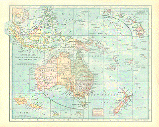
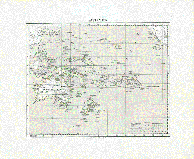
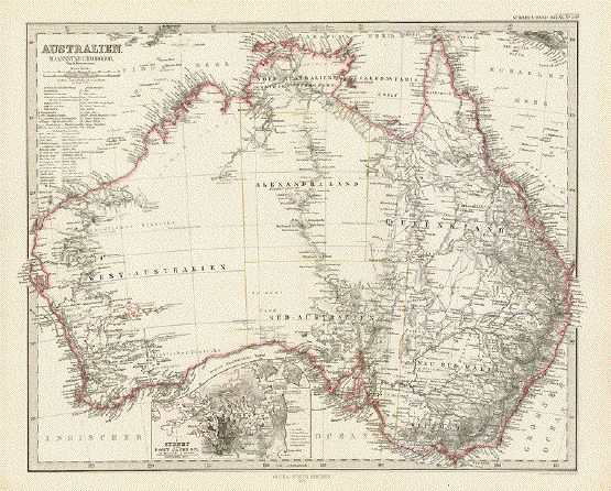
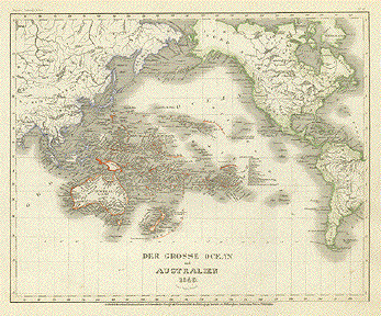
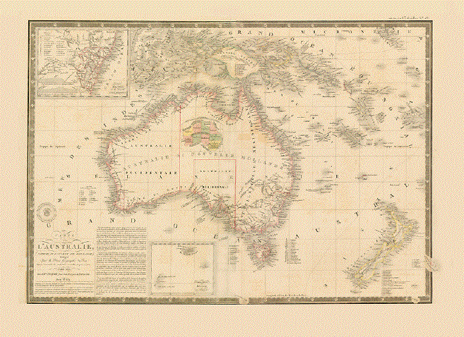
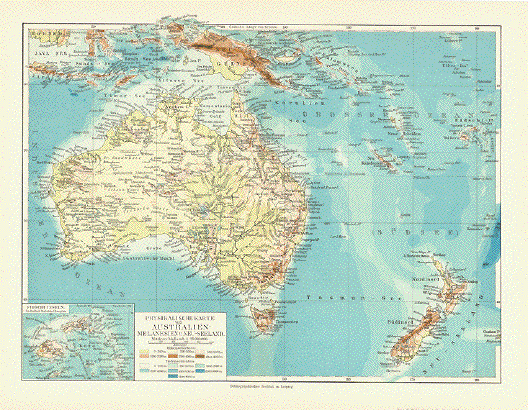
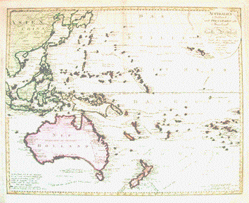
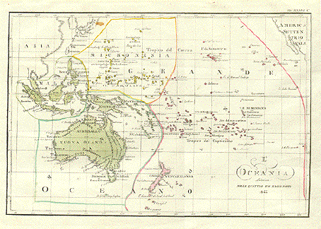
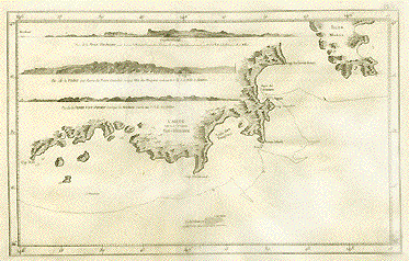
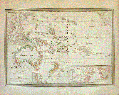
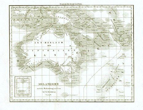
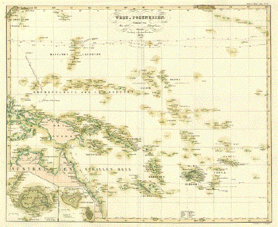
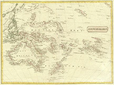
"Australien". Copper etching from a German source ca 1800. Original hand outline coloring. 
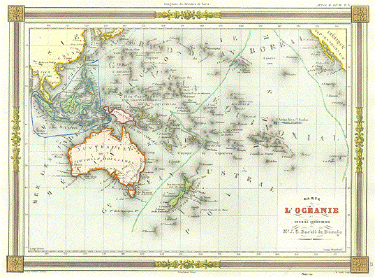
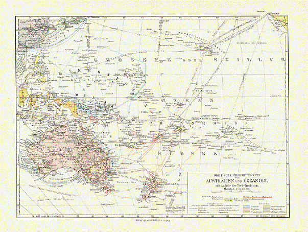
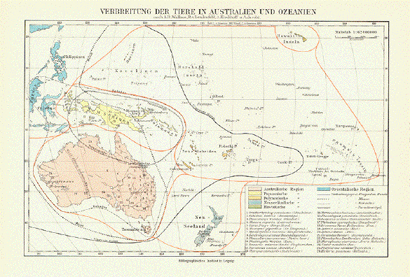
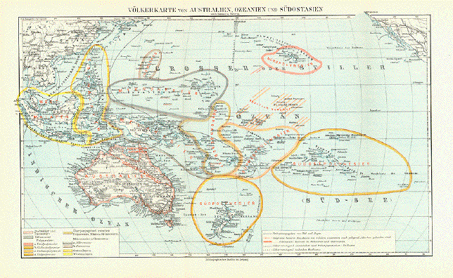
Interesting map of Australia, New Zealand, Southeast Asia and the South Pacific. In the upper left is a bit of mainland China and in the upper right a tiny corner of California with San Diego. On the right edge are the Easter Islands and at the lower center are Campbells and Macquarries Islands. 
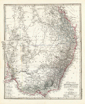
Map has wide margins and hardly any spotting. Repair on lower margin and two tiny repairs in image that are only visible from the backside. Condition is otherwise Better than Good. 
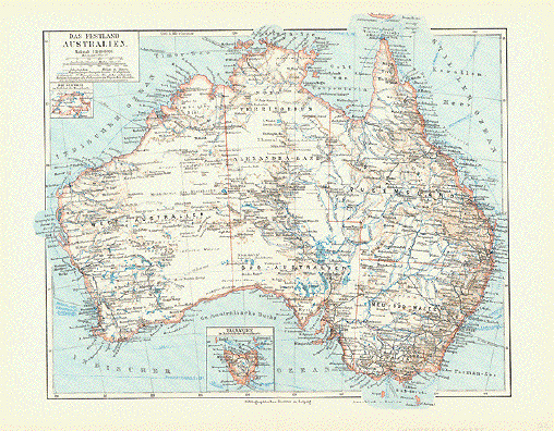
29.2 x 39 cm ( 11.4 x 15.3 ") $ 375.00 Order Nr. AUSTRALIA2304 |
|
|
"A Map of the Route of the
Expedition Copper engraving published in
London. Map shows Melville Island with the names of landmarks and early settlements. A few light spots. 18.2 x 10.7 cm ( 7.1 x 4.2 ") $ 75.00 Order Nr. AUSTRALIA2318 |
|
"Carte de L'Océanie dresée et dessinée Sous la Direction de Mr. J.G. Barbie du Bocage". Steel engraving by Ch. Smith published in Paris by Maison Bassett ca 1850. Modern hand coloring. A detailed and decorative map showing the southern Pacific and Asian region. Except for some very minor spotting in margins, the map is in Very Good condition. 22.4 x 30.5 cm ( 8.8 x 12 ") $ 350.00 Order Nr. AUSTRALIA2298 |
|
"L'Oceania divisa nelle Quattro Sue Magne Part 1844". Lithograph from an Italian source, ca 1850. Original hand coloring. It is easy to see the large area encompassed on this map of Oceania. In the upper left is part of China and Japan. In the upper right is paer of North America. Map has wide margins with some light creases in margins, especially on edges. There is a spot on the map image in the norther part of Japan. S few very light scattered spots in margins. 21.5 x 32 cm ( 8.4 x 12.6 ") $280.00 Order Nr. AUSTRALIA2308 |
|
"Océanie". Steel engraving by Laguillermie for C.V. Monin, ca 1850. Original outline coloring. This map shows the various divisions of Oceania. In the lower right corner is an inset showing part of the eastern coast of Australia. Sydney is in the midlle of the coastline. At the bottom of the inset is the Muroo River. At the top is Cape Smokey and the Cockburn River. Map has vertical centerfold. Tiny repaired tears on lower margin edge. Spotting on lower right margin edge. 28 x 39.5 cm ( 11 x 15.5 ") $320.00 Order Nr. AUSTRALIA2307 |
|
"Carte de la Terre Van-Diemen". Copper engraving by Bernard for Captain Cook's travel report, 1785. This map is from the first French edition. Map shows topographical details of parts of Tasmania and the surrounding area. In the upper right is part of Isles Maria. In the upper left is "Vue de la Terre Van-Diemen par dessous la Pointe Camelee lorsque le Cap Meridional reste au N.N.E.1/2E. a la distance de 7 milles". Below that is the stretch of mountains; "Vue de la Terre par dessous la Pointe Camelee lorsque L'Isle des Pinguins reste au N.O. 1/4 O. a 1 mille de distance." The third detail of lower mountains: "Vue de la Terre Van-Diemen lorsque la Mewstone reste au N. 1/2 E. a % milles." The coastline with various islands reaches from Cap S.O on the left side to Cap Frederick Henry. In the center is Cap Meridional. At the bottom center of the map is Pedro Blanco and Eddystone. A dotted line shows the route of Captain Cook. Map has original vertal fold to fit book size.Very minimal spotting. In the lower part of map are light creases and an area of light rubbing that hardly distubs the overall map condition. 22.8 x 35.2 cm ( 8.9 x 13.8 ") $ 285.00 Order Nr. 2313 |
|
Upper image: Vue du Côte Méridional de la Baye de L'Aventure. Lower image: Plan de la Baye de LÁventure fur la Terre Van-Diemen. Copper engraving by Bernard for Captain Cook's travel report, 1785. This map is from the first French edition. The top image shows part of Aventure Bay with the little Isle Penguin on the left side. At the botten is a more detailed image of the Bay of Aventure with Isle Penguin. Cap Camelee and the Aguade River are shown. There is a hortizontal and vertical fold to fit book size. The upper left margin has been added. There is a repaired tear in the upper left area. A few minor creases. 24.5 x 20 cm ( 9.6 x 7.8 ") $ 190.00 Order Nr. AUSTRALIA2314 |
|
"Der Grosse Ocean und Australien 1849." Steel etching from "Neuester Zeitungs Atlas. Alter und Neuer Erdkunde" by J. Meyer, ca 1855. Some original outline coloring. Map shows the wide area of the Pacific Ocean, Australis and the bordering countries. Except for some very minor spotting in margins, the map is in Almost Very Good condition. 21.1 x 26 cm ( 8.3 x 10.2 ") $ 90.00 Order Nr. AUSTRALIA2306 |
|
"Australien und Polynesien" Steel engraving by W. Alt after Herm. Berghaus, ca 1850. Original outline coloring. Fine map with the entire Pacific region. In the lower right is an inset of southeast Australia and Tasmania. In the lower left are conical forms representing the highest mountains of the area. These rage the Mauna Kea to Ualan. Map has some minimal rubbing in upper left corner. A few islands have been underlined in light blue. Very clean. Very tiny crease in lower left margin corner. 19.8 x 25.7 cm ( 7.8 x 10.1 ") $ 120.00 Order Nr. AUSTRALIA2316 |
|
"Australische Inseln" Wood engraving printed in color by the Bibliographisches Institut in Leipzig, 1882. Very detailed map with major shipping routes. To the right of the title is a map of Germany for size comparison. The map has vertical folds to fit atlas size. Small repaired tears in margins. 20.7 x 42.5 cm ( 8.1 x 16.7 ") $ 90.00 Order Nr. AUSTRALIA2315 |
|
"Australia". Wood engraving printed in color by Fisk and See in New York ca 1880. The map shows the railway lines as well as some unfinished railways throughout Australia. Lines in the ocean show distances to major destinations. Map has vertical centerfold. 23 x 28.5 cm ( 9 x 11.2 ") $ 75.00 Order Nr. AUSTRALIA2317 |
|
"Part of South Australia". Steel etching drawn and engraved by J.Rapkin with some borderline coloring. The illustrations are by H. Warren and J. Rogers. Published by John Tallis & Company of London & New York. Ca. 1860. This very detailed map shows the part of South Australia that includes Adelaide and the surrounding area. It's easy to see Spencer Bay, Gulf St. Vincent and Kangaroo Island. In the lower left is the "Seal of South Australia". Further north on the west side are two aboringines on a river raft. In the upper left is a partial view of Adelaide. In the upper right is is "dingo" and a "nymphicus". Light toning, horizonal fold, two small tears repaired in right margin. condition is otherwise Very Good. Size of map without border: Ca.22 x 30 cm ( 8.7 x11.8 ") $ 250.00 Order Nr. AUSTRALIA2292 |
|
" New South Wales". Steel etching drawn and engraved by J.Rapkin with some borderline coloring. The illustrations are by H. Warren and J. Rogers. Published by John Tallis & Company of London & New York. Ca. 1860. Most of New South Wales is shown on this map. It shows the area as far as the Darling river in the west. In the north is part of Queensland as far as Great Sandy Island. In the lower left is the Murray River with typical vegetation including a Panandus tree. In the lower left is a Xanthorrhæa. In the upper left is a decorative view of part of Sydney Cove and abouve that the Seal of New South Wales. Light toning, horizontal fold. Condition is Almost Excellent. Size of map without border: Ca.22 x 30 cm ( 8.7 x11.8 ") $ 250.00 Order Nr. AUSTRALIA2293 |
|
"Australien" Steel engraving by C.F. Weiland in Weimar. Published in the Geograph. Institut in 1846. Original hand outline coloring. Map show Australia and New Zeland and the many islands of the South Pacific. In the upper left corner is part of China and Japan. In the upper right corner is part of the coast of California and northern Mexico. In the lower left is a detailed inset of the southwest of Australia. In the lower right are two detailed insets; on the left inset is New south Wales and in the lower right corner is Van Diemens Land (Tasmania). Map has wide margins and a vertical centerfold. A few light, parallel creases near centerfold. Minor scattered spots in map and light spotting and browning in margins. Two tiny repaired tears on lower margin edge. 44 x 62.2 cm ( 17.3 x 24.4 ") $ 530.00 Order Nr. AUSTRALIA2311 |
|
"Australien" Steel engraving by W. Kratz, C. Poppey and C. Graf, 1857. Original outline coloring. Map shows Australia, New Zeland, part of China, Japan and Southeast Asia. In the upper right is a bit of the California coast by San Francisco. At the bottom of the map are detailed insets. In the lower right corner is an inset of Tahiti. Under it is one of the Hawaiian islands. To the left is New Zealand. In the lower left corner are insets of the australian coast from Bateman Bay to Clarence in the north. Sydney is on the middle of the coastal detail. The other inset shows Tasmania. Map has vertical centerfold with a few light parallel folds near center. Small repaired tear in lower margin edge on centerfold. Outline coloring is a bit lighter than on the image above. Overall light toning. 52.5 x 65 cm ( 20.6 x 25.5 ") $ 520.00 Order Nr. AUSTRALIA2310 |
|
Title left side:
"West
Australien", Upper center:
"Tasmania" Steel engraving by Stier and
Stichart. Published in Gotha. Dated 1874. Map has very light age toning
and minimal scattered spotting in margins. 34.3 x 40 cm ( 13.5 x 15.7 ") $ 260.00 Order Nr. AUSTRALIA 2296 |
|
Van Diemens Land. Tasmania. Steel etching in original coloring after a drawing by J.W. This map was sold by James Gardner jr. Sidney, 1843. Dry stamp in lower right. This clean and detailed map of Tasmania has a repared tear in the lower margin reaching about 1 cm into image. Otherwise Very Good. 27 x 22.4 cm ( 10.6 x 8.8") $ 290.00 Order Nr. AUSTRALIA 2297 |
|
"Carte Du Continent Australien, Et Tracé Du Voyage." Wood engraving from "Atlas de
Mr. Bonnefont", published in Paris ca 1865. Original outline
coloring. 20.5 x 30.2 cm ( 8 x 11.8 ") $ 180.00 Order Nr. AUSTRALIA 2305 |
|
" Carte de l'Hemisphere Austral". Copper etching by Benard. Published in "Voyages de Cook", Tome I ca. 1780. Original hand coloring. The South Pole is the center of this southern map of the world. The vertical line in the center is the Greenwich Meridian, In the lower left is the southern part of Africa. In the lower right is the southern part of South america with Brazil colored green. In the upper left is Australia and part of southeast Asia. The exploration routes of Captain Cook are shown. In all the corners are the names of newly explored islands and newly founded settlements with degrees of longitude and latitude. The map has several fold to fit book size. Overall light toning. Condition is Almost Very Good. 53.4 x 53.4 cm (21 x 21 ") $ 1300.00 Order Nr. AUSTRALIA2169 |
|
"West-Polynesien" Steel etching by C. Poppey after W. Berghaus for "Stieler's Hand Atlas". Published in Gotha 1854. Original hand outline coloring. This map of western Polynesia shows Australiaa and New Guinea in the lower left corner. There are two detailed insets showing the island of Witi Lewu and Tongabatu. In the lower right are Tonga and the Fidji Islands. Map has vertical centerfold, light browning on margin edges and very minimal spotting in margins. Condition is Much Better than Good. 33.5 x 41 cm ( 13.1 x 16.1 ") $ 400.00 Order Nr. SOUTH PACIFIC 2511 |
|
"Southern Hemisphere Projected on the Plane of the Horizon of London". Copper etching by J. & G. Menzies after Geo. Buchanan for "Thomson's New General Atlas", published in 1816. Original hand coloring. This very interesting map shows the southern hemisphere with the South Pole shown in sketchy form. Notice Australia and Southeastern Asia on the upper left side. In the upper right part of the map are the Sandwich Islands (Hawaiian Islands). On the lower right is the southern part of South America. Lines show the various exploration routes of early explorers. Map has browning on left margin, especially in the upper and lower corners. Horizontal centerfold. Lower margin edge is a bit frayed on right side. In upper margin is a light brown line.General condition is Better than Good. Page size: 61 x 53.5 cm ( 24 x 21 ") Diameter of map: 50 cm ( 19.6 ") $ 400.00 Order Nr. AUSTRALIA302 |
|
"Asiatischer Archipel und Neu Holland 1849". Steel etching from "Neuester Zeitungs Atlas. Alter und Neuer Erdkunde" by J. Meyer, ca 1855. Some original outline coloring. Southeast Asia and Australia are shown on this map of the area as it was in 1849. On the middle left side is a detailedbinset of southwestern Australia with Perth, Augusta and Albany. In the lower left is a detailed inset of New South Wales with Hastings and Fort Macquarie in the north and Murray and Bateman's Bay in the south. In the upper right of the map are the Ralick Islands and Radack Islands with the Gilbert Archipelago a bit further south. In the upper left are the Andaman Islands. Notice that the Philipine Island of Luzon reaches over the map outline at the top of the map. At the bottom is a color scale matching outline colors on the map and representing the colonies and mother countries. Map has light browning on margin edges. Overall condition is otherwise Almost Very Good. 21.7 x 26.7 cm ( 8.5 x 10.5 ") $ 120.00 Order Nr. AU2303 SOLD |
e-mail:philographikon@t-online.de
Terms of Sale - Lieferbedingungen