Antique Maps of Bulgaria and Moldavia

Please let us know if you are looking for special maps. All maps are in good condition unless otherwise mentioned.

Ordering and Payment

Lieferbedingungen

Sale! Discount!

30% Discount on All maps with a BULGARIA number on this page!

Take 30% off the listed price. !

"Danubius Fonte ad Osdtia"

The course of the River Danube from source to mouth in the Black Sea.

Copper etching. Original hand color.

By Peter van der Kererre (Latinized: Petrus Kaerius (1570-1630)

Published in "Atlas Minor" (Small hand atlas) by Mercator/Hondius

Amsterdam, 1607

Minor signs of age and use in margins. Hardly visible vertical centrfold.

Page size: 17 x 20.5 cm ( 6.6 x 8.4")

$195.00

Order Nr. DEUTSCHLAND250405


"Thraciae Descriptio"

Cluver, Philipp (1580 - 1623) was an early author of historic maps.
His works were published long after his lifespan. This map( comes from a pocket size atlas (duodez):
Philippi Cluverii. Introductionis inUniversam Geographiam tam veterem quam novam Libri. Amsterdam, 1661.
The engraver was Peter Bertius (1565 - 1629). Originally colored.

The side margins have been added. Minimal foxing.

Size: ca.12 x 12.5 cm (ca.4.72 x 4.92").

$ 130.00

Order Nr. BALKANMAP249819


"Turquie D'Europe"

Steel engraving map, 1862. Shows Balkan and Greee at the time of Turkish domination.

Vertical folds to fit original book size. Right and lower margins have ben added.

Some signs of age and use in margins.

17.5 x 23 cm ( 6.8 x 9 ")

$ 70.00

Order Nr. TURKEYMAP255101


"Romaniae, (quae olim Thracia dicta) Vicinarumque Regionum, Uti Bulgariae, Walachiae, Syrfiae, etc. Descriptio. Auctore Iacobo Castaldo MDLXXXIIII"

One of the most beautiful maps in the Theatrum Orbis Terrarum. A Renaissance cartouche of size and beauty!

Type of print: Copper etching

Color: Exquisite hand coloring

Artist: Jacobo Castaldo (Jacopo Gastaldi ca. 1500-1586)

Published: In "Theatrum Orbis Terrarum". Antwerp, dated 1574

Publisher: Abraham Ortelius (1527-1598)

Verso text: Latin

Condition: Except for very minor traces of age and use in margins: Near excellent.

Especially the hand coloring is superb. A real collector's item!

36,3 x 50 cm (ca. 14.3 x 19.7")

Order Nr. ROMANIA/MAP239954SOLD


ăPrincipati di Moldavia E Vallachia Tratti dalle Carte dell'Impero Ottomano del Sig. Rizzi Zanoni"

Shows the part of Romania, which was earlier called Wallachia. Also shown Moldavia and parts of Ukraine. Parts of north-west coast of the Black Sea.

Copper etching by Antonio Zatta. Original hand coloring

Venise (Venezia, Venedig). Dated 1782

Condition: Very good. Wide margins

ca. 31 x 40,5 cm (ca. 12,.2 x 16")

$ 220.00

Order Nr. ROMANIA238397SOLD


Reverse side:

"Part of European Turkey" and side map "The Bosphorus & Constantinople"

Reverse side: "Constantinople & Part of Asia Minor"

Wood engraving. Printed by Schoenberg, New York City. 1867

Front sideshows Black Sea coast line from Constantinople (Istanbul) north to Varna, Bulgaria and as far west as 25° Eastern Length on the Balkan.

Reverse side: Coastline of Black Sea from Constantinople (Istanbul) to Samsun, Sea of Marmara, Smyrna (Ismir) as far east as Tokat

Small side map shows the Bosphorus channel from the Sea of Marmara to the Black Sea.

Very good condition.

11,8 x 15,3 cm (ca. 4.6 x 6")

11,8 x 21 cm (ca. 4.6 x 8.3")

11.8 x 4,5 cm (ca. 4.6 x 1.8")

$ 60.00

Order Nr.BULGARIA239985


"Rumaenien, Bulgarien, Serbien und Montenegro"

Detailed map of Romania, Bulgaria, Serbia and Montenegro published 1892.
In the upper left is a detailed inset of Bukowina and Jassy,
Vertical centerfold. Light age toning in margins.

21 x 26.5 cm ( 8.2 x 10.4 ")

$ 55.00

Order Nr. ROMANIAMAP249144


ăLe Provincie di Bulgaria, E Rumelia Tratte dalla Carta dell'Impero Ottomanodel Sig. Rizzi Zanoni"

Shows the Bulgarian Black Sea coast and the tiny tip of Turkish Europe and a piece of Greece.

Also shown Constantinopel (Istanbul), Sea of Marmara, the Dardanelles, the island of Limnos , and Athos

Copper etching by Antonio Zatta. Original hand coloring

Venise (Venezia, Venedig). Dated 1781

Condition: Very good. Wide margins. Small spot in lower margin.

ca.41 x 31,5 cm (ca. 16 x 12.4")

$ 220.00

Order Nr. BULGARIAMAP238371


"Carte de la Bulgarie et des Monts Balkan 1854"

Line lithograph map published in Paris in 1879.

Very clean map with original folds to fit book size.

22.8 x 18 cm ( 9 x 7.1 ")

$ 70.00

Order Nr. BULGARIAMAP234974


ăDie Laender der unteren Donau vom Vten bis in das Xte Jahrhundert". Countries along the lower Danube from the 5th into the 10th century.

Steel etching by W. Alt. 1846. Faint borderline coloring.

Clean.

Page size: 37 x 43.8 cm (14.6 x 17.2").

$ 180.00

Order Nr. BULGARIAMAP0903


" Die Europaeische Tuerkei" Steel engraving after H. Habenicht for Stieler dated 1870. Original outline coloring.

In the north is a part of Slovenia and Romania (Siebenburgen). In the upper right corner is Moldavia. Further south is Bosnia, Serbia and southern Romania. In the central part is Montenegro colored pink on the left and Bulgaria on the right. Part of the black Sea is n the right edge of the map. In the lower center is Macedonia. On the lower left are two insets. The upper one shows the Maramara Sea, Bosporus and a bit of the Black Sea. The lower inset is a very detailed plan of the Bosporus.

Map has a small repair on centerfold in lower margin.

33.5 x 43 cm ( 13.1 x 16.9 ")

$ 125.00

Order Nr. BULGARIAMAP235800SOLD


ăPontus Euxinus Aequor Iasonio pulsatum remige primum" The Black Sea

Hand-colored copper etching. Published in ăParergon, sive veteris geographiae aliquot tabulae" - the historic part of ăTheatrum Orbis Terrarum" by Abraham Ortelius. Antwerp, 1590. Verso: Text in Latin about the Black Sea area.

The attractive historic maps in the Ortelius atlas bear the old classical place- and land names.

This map comprises all abutters of the Black Sea and rivers that run into the Black Sea.

Starting from Turkey which owns a tiny corner of Europe and the entire Black Sea Coast in Asia we continue clockwise: Bulgaria, Romania, Ukraine, Russia, Georgia.

A decorative title cartouche embellishes this very attractive map.

There are some signs of age and use in margins. Centerfold has been reinforced.
Some very minor holes visible when map is held to light. Small repairs in upper margin.
Repair on lower centerfold.
Side margins have been added through use of paper fiber.

35 x 49 cm (13.8 x 19.2")

Order Nr. UKRANIAMAP250586SOLD


"Spezial-Karte der Dobrudscha" ( Dobrogea, Dobruca, Trans-Danubian )

Wood engraving ca 1885. Reverse side is printed ( in German ) with an article about the Russian-Turkish war.

On the right side is the mouth of the Danube River that "flows" into the map in the lower left corner. The map shows the railroads and roads that existed at the time.

Map has overall light age toning.

23.5 x 31.5 cm ( 9.2 x 12.4 ")

Order Nr. ROMANIAMAP239948 SOLD


"Des Fuertenthums Moldau noerdliche Haelfte" North of the pricipality of Moldau.

Copper etching from the atlas by Franz Johann Joseph von Reilly ăSchauplatz der fuenf Teile der Welt". Vienna, 1791. Original hand coloring.

Map shows parts of Moldavia, Ukraine, and Romania with the rivers Pruth and Dnister (Dnjstr). From Chotin to Lapusna. Map shows areas of Moldavia, Ukraine and Romania.

Flawless condition.

20.8 x 28.8 cm (8.2 x 11.3")

$ 230.00

Order Nr. BULGARIAFMOLDAVIAMAP0905


"Des Fuerstenthums Moldau Suedliche Haelfte". Copper etching in original hand coloring from the "Postal Atlas", Reilly, Vienna, 1791.

Bacau (Bakow) in Romania is in the center of this map. At the bottom of the map to the left osf the cartouche is Galati and the confluence of the Brut and Siret rivers. At the top of the map is Harlau (Harleu), In the lower left is Kronstadt. In the upper right is Orhei in Moldavia.

Map has very wide margins. Map image is very clean. A few minor spots in margins.

20.7 x 28.5 cm ( 8.1 x 11.2 ")

$ 230.00

Order Nr. BULGARIAMOLDAVIAMAP0901


"Das Fuerstenthum Walachey". Copper etching in original hand coloring from the "Postal Atlas", Reilly, Vienna, 1791.

The Danube River is very prominent in the lower part of this map. On the left it begins with Old and New Orsova and on the right it "flows" out at Braila. In the upper right is Tecuci (Tekutsch). In the upper left is Caransebes (Karansebes). Bucharest is shown with a red point.

Map is clean with wide margins. Small crease in lower margin.

21.2 x 32 cm ( 8.3 x 12.5 ")

$ 230.00

Order Nr. BULGARIAMAP0902


ăCarte du Cercle de Bukovine - Karte des BukowinerKreises". Anonymous copper etching with original outline coloring. Sheet map (not published in an atlas). Ca. 1780 -1810.

This very detailed map of the Bukowina, an area which was rarely given detailed cartographical attention to, really shows every village, city river, mountain. It is a large and very detailed topographical account .Upper left technical title cartouche in French and German.

Map has centerfold and and three horizontal folds. It was folded up like most sheet maps were. Minor spotting in margins. Otherwise in very good conditon

57.5 x 40.8 ( 22.6 x 16 ")

$ 600.00

Order Nr. BULGARIAROMANIA0900SOLD


ăUngarn und seine Nebenlande bis zum Aussterben bis zum Aussterben des Arpadischen Stammes 1301". (Hungaryup to the extinction of the Arpadic clan. 1301.)

Steel etching by W. Alt. 1846. Faint original borderline coloring.

Clean except for some light stains in the margins.

Page size: 37 x 43.8 cm (14.6 x 17.2").

$ 180.00

Order Nr. HUNGARYMAP1261


ăUngarn und seine Nebenlande vom Regierungs-Antritte des Hauses Anjou bis zur Schlacht von Mohacs 1526". (Hungary and its neighbors from the Anjou taking power until the battle of Mahacs 1526.)

Anonymous steel etching 1846. Faint original borderline coloring..

Clean except for some light stains in the margins. Tiny repaired tear in lower left margin corner.

Page size: 37 x 43.8 cm (14.6 x 17.2").

$ 180.00

Order Nr. HUNGARYMAP1259.


ăUngarn und seine suedlichen Nachbarlaender seit 1526". (Hungary and its neighbors to the south since 1526.)

Anonymous steel etching 1846. Faint original borderline coloring. Interesting place-names.

Clean except for some stains in the margins.

Page size: 37 x 43.8 cm (14.6 x 17.2").

$ 180.00

Order Nr. HUNGARYMAP1260.


ăUngarn und seine Nebenlande nach ihrer kirchlichen Eintheilung bis in das XVte Jahrhundert". Hungary

according to the division of dioceses up to the XVth century.9

Steel etching by C. Stier. 1846. Some very faint borderline coloring.

Clean except for some stains in the margins.

Page size: 37 x 43.8 cm (14.6 x 17.2").

$ 180.00

Order Nr. HUNGARYMAP1258


"Europaeische Tuerkey Griechenland und die Ionischen Inseln 1850." Steel etching by Renner from "Neuster Zeitungs Atlas. Alter und Neuer Erdkunde" by J. Meyer, ca 1855. Original outline coloring.

Very interesting historical map showing the region that was under Turkish rule. (the part within the blue lines). The map is very detailed. In the upper left corner is a small part of Austria. In the upper right is part of Podolien and Cherson in Ukrania. At the bottom of the map is a color key showing the political divisions of the region that corresponds to the colors of the lines on the map.

Very clean map with wide margins.

23.5 x 18.2 cm ( 9.2 x 7.1 ")

$ 125.00

Order Nr. GREECEMAP1294


"Carte des Environs de la Mer-Noire ou se trouvent L'Ukrayne, La Petite Ratarie et les confins de la Russie Europeene et de la Turquie"

Copper etching with original borderline hand coloring by Robert de Vaugondy.

Our exemplar was published in the Italian edition by Santini. Venice, 1779

Neighbors of the Black Sea: Ukraine, Russia, Georgia, Turkey, Romania, Bulgaria. especially the Ukraine is quite detailed including the Crimea

Flawless

49 x 64 cm (19.3 x 25.2")

$ 620.00

Order Nr. UKRAINIAMAP235347


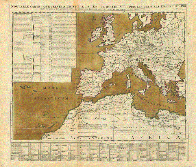
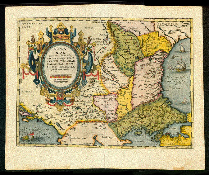
"Nouvelle Carte pour servira L'Histoire de L'Empire D'Occiendent depuis les premiers

Empereurs Romains jusques après les successeurs de l'empereur Theodose

avec des tables et des remarques très instructives"

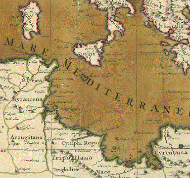
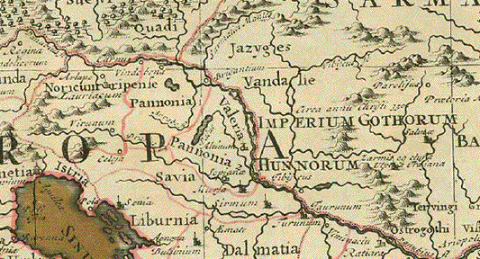
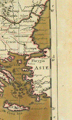
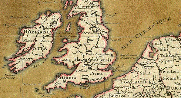
The Roman Empire (West Rome) around 400 A.D.

Interesting names given by the Romans to the peoples in Europe.

Map has 2 vertical and 1 horizontal folds. All Sea waters have original hand color

as well as border lines. Copper engraving map.

Published in: "Atlas Historique, Ou Nouvelle Introduction A l'Histoire, à la Chronologie

& à la Géographie Ancienne & Moderne: Représentée dans de Nouvelles Cartes,

Où l'on remarque l'établissement des Etats & empires du Monde, leur durée, l

eur chûte, & leurs differens Gouvernemens"

Published in Amsterdam 1720

Overall natural age toning and a few signs of age and use.
Small repairs on centerfold.

Overall size: 50 x 58 cm (19.6 x 22.8")

$ 420.00 ( See discount above!)

Order Nr. EUROPE255021


Antique Maps of Romania

Antique Prints of Bulgaria and Moldavia

Antique Prints of Romania (Rumania)

Antique Maps from Around the World

Ordering and Payment

E-mail

Terms of Sale - Lieferbedingungen

Home Page

Impressum

Datenschutz

Copyright by Rainer Rauhut