ALL PRINTS AND MAPS ON OUR WEBSITE ARE OVER 100 YEARS OLD.
THEY ARE CUSTOMS-FREE FOR IMPORT INTO THE USA.
|
Alte Landkarten von Deutschland (Seite 1) Antique Maps of Germany (Page 1) This is a selection of our historical maps of Germany. There are several pages more. Click the link at the bottom of the page to see more. If you are looking for a particular map please contact us. If you want to know if a certain town or city is on one of our maps, please ask. Sale! Discount! I am 87 years old and selling my stock. 30% Discount on All maps with a DEUTSCHLAND number on this page! We accept offers. Visit us at the following sites: https://lovelyantiqueprints.com twitter.com/philographikon2 All prices are US $. |
|
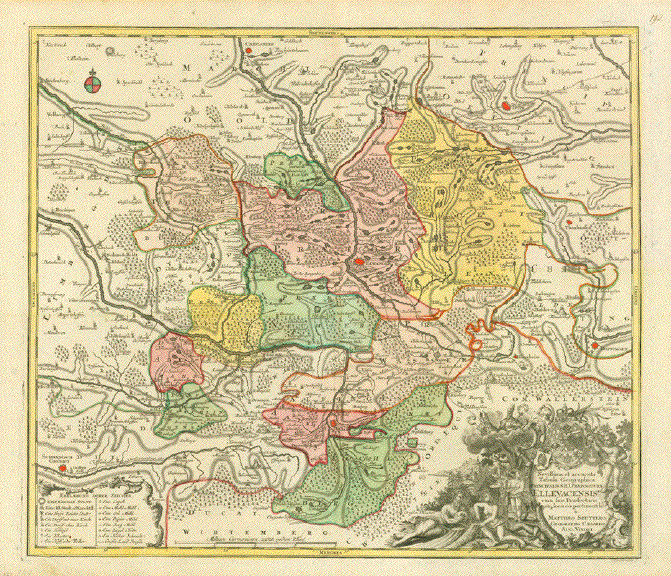
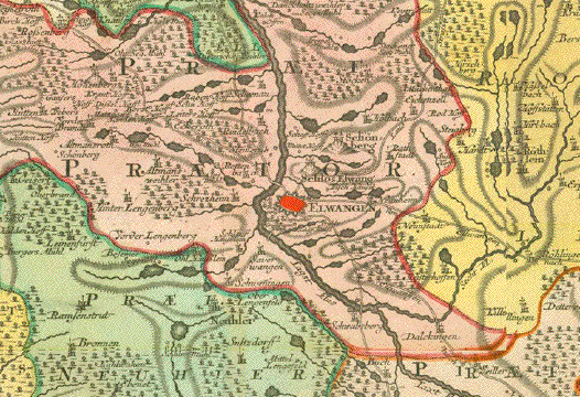
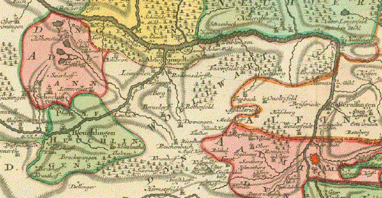
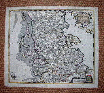
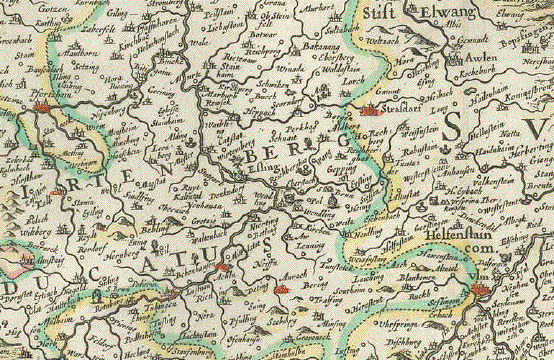
Ellwangen. - "Novissima et accurata Tabula Geographica Principalis S.R.I. Praepositurae Ellevacensis cum suis Praefecturis atq. locis eo pertinentibusè" Copper etching map of Ellwangen in Bade-Württemberg and its immediate surroundings. Original hand coloring. Copper etching by Conrad Lotter (1707-1777) Published by Matthaeus Seutter (1678-1757) Augsburg, 1746 Very detailed map with an ornate baroque title cartouche. Very good condition. With
attractive original hand coloring. Reverse side is
blank. 49 x 57 cm (ca. 19.3 x 22.4") $ 890.00 minus 30% Discount = $ 623.00 Order Nr. DEUTSCHLAND254012 |
|
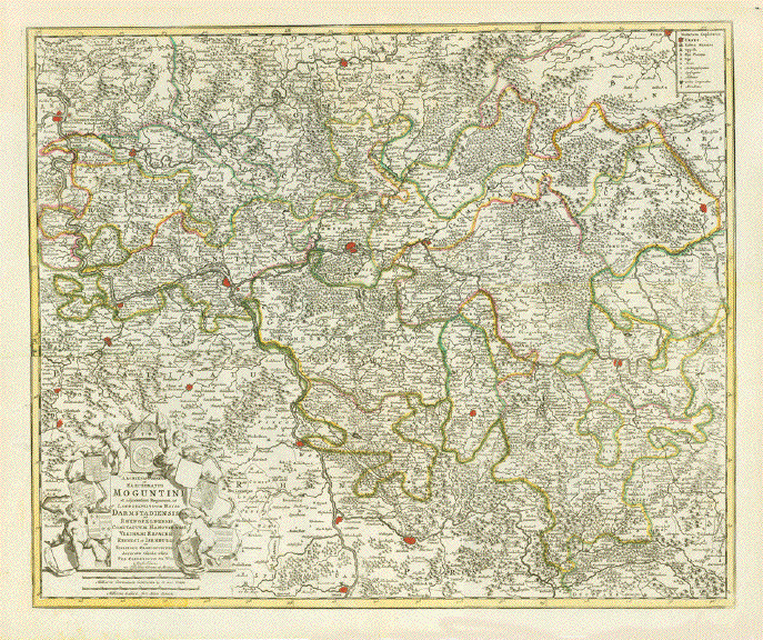
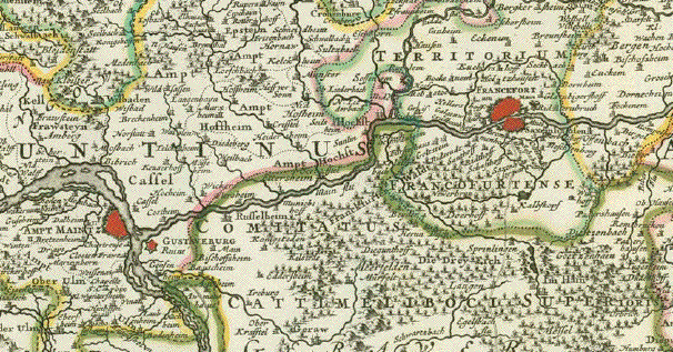
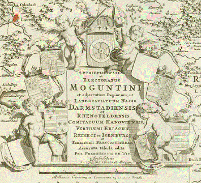
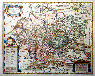
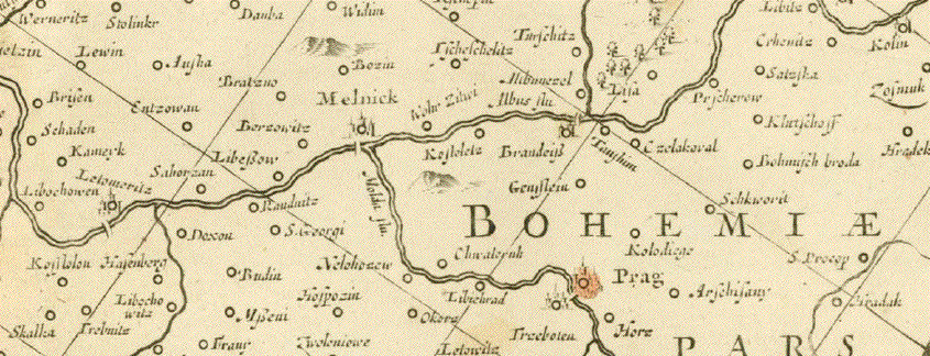
"Archiepiscopatus et Electoratus Moguntini et Adjacentum Regionum, et Landgraviatum...." Copper engraving map by F. de
Wit in the Composite Atlas by Covens and Mortier published
from 1721-41. The map extends from Wetzlar in
the north to Speyer (Spier) in the south. Original hand outline colorng. Map image is clean. Small repairs in upper margin
edge on the centerfold and in the lower margin edge on
centerfold. Map image: 48.5 x 59 cm ( 18.9 x 23") $ 460.00 minus 30% Discount = $ 322.00 Order Nr. DEUTSCHLAND253313 |
|
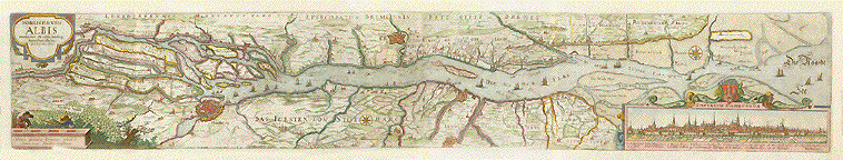
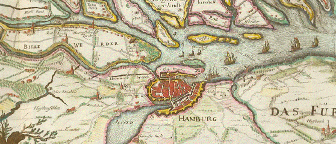
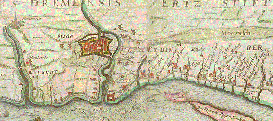
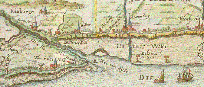
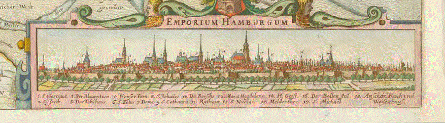
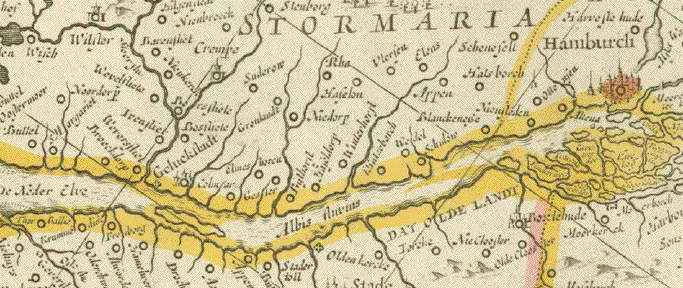
"Nobilis Fluvius Albis maxima cura ex variis famosisque Auctoribus collectus et in lucem editus" Beautifully hand-colored, very detailed copper etching showing the run of the river Elbe from Marschacht (ca. 30 Km east of Hamburg) to Cuxhaven, where the river empties in form of an estuary into the North Sea. From Cuxhaven to Hamburg is the stretch of the river which all ships have to go through in order to reach the international harbor of Hamburg. The city of Hamburg is shown both as an areal view as well as a beautiful panoramic view, an inset into the map in the lower right corner. In the lower left corner there are two land surveyors at work. On the river's south side: Harburg - Buxtehude - Stade. On the river's northern shores: Hamburg - Blankenese (still a distant village) - Glückstadt - Krempe. And on both sides of the Elbe run to the sea every little village and small town. As well as the various arms of the river Elbe, and even very small feeding river and stream on either side. Etched by Jan Janssonius (1588-1664), an important member of the Dutch 17th century map producer dynasty in Amsterdam this map has extraordinary extensions. The map was produced and published in Amsterdam, 1636 Because of the oblong shape, the map has several vertical folds. It is in very good condition, and the hand coloring is of outstanding quality.The margins are ample. Very minor signs of age and use. 17,1 x 102,5 cm (ca. 6.7 x 40.4") Order Nr.HAMBURG251962SOLD |
|
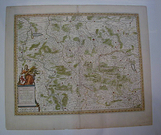
"Praefecturae Altenburgensis et Ronneburgensis earumque vicinia Serenissimo Duci Saxo Gothano parentes geographica tabula expressae a Matthaeo Seuttero Geograph. Caesar. Aug. Vindel" Altkolorierte Kupferstichkarte von Tobias Conrad Lotter (1717-1777) Erschienen bei Mattheus Seutter (1678-1757) Augsburg, ca. 1740 Sehr detaillierte Umgebungskarte der Städte Altenburg, Thüringen und Ronneburg, Thüringen. Im Norden reicht die Karte bis Lukas und Borna, im Osten bis Penig, im Süden bis südlich von Glauchau und Crimmitschau, im Westen bis Weida und Gerau. Sehr gut erhaltene Landkarte mit ausgezeichnetem Altkolorit. Im unteren Bereich Titelkartusche im barocken Stil. Links unten Meilenanzeiger. Ausserhalb der Karte links und rechts Ortsverzeichnisse mit Suchangaben zum Planquadrat. Margen oben und unten schmal. Schwarze Rand ist Scan Hintergrund. Black margins are scan background and not part of map. 49,3 x 58 cm $ 380.00 (Net liquidation price / Netto Ausverkaufpreis) Order Nr. DEUTSCHLAND257557 |
|
ÐAccurate Geometrischer General Ris des Stiffts Merseburg" Wunderschön altkolorierte Kupferstichkarte von Petrus Schenk jr. (1693-1775) Amsterdam, datiert 1745 Sehr detaillierte und dekorative Karte des südlichen Teils von Sachsen-Anhalt mit dem Verlauf der Saale von Dalitz bis Halle und der Gegend um Leipzig. Links unten barocke Titelkartusche. Der vertikale Mittelfalz wurde von alter Hand teilweise hinterlegt 46 x 55,5 cm $ 450,00 (Net Liquidation Price / Netto Ausverkauf-Preis) Order Nr. DEUTSCHLAND257556 |
|
"Accurate Geopgraph: Deklination des in dem Meisnischen Kreise liegenden Ammtes Senftenberg. Nebst allen daran grentzenden Aemmtern, Herrschaften und Gegenden in Amsterdam bei Petrus Schenk mit Königl. Und Churfürstl. Saechs. Privil. M DXX LVII" (1757) Very nicely kept copper etching with original hand coloring By Pieter Schenk the younger (1693-1775) Sehr detaillierte und attraktive Kupferstichkarte von Peter Schenk Jr. Mit planquadratischer Bezifferung oben unten / links rechts Beispiel A / a, um Orte, Wälder, Berge, Gewässer und Einzeln stehende Häuser leicht zu lokalisieren. Unten rechts: Zeichenerklärung. Links unten Meilenanzeiger Im Norden reicht die Karte bis Vetschau und Cottbus. Im Osten bis zum Lauf der Spree. Im Süden bis Ortrand, Cracau, Wittichenau. Im West bis, Sonnenwalde, Finsterwalde, Gröden. Wunderschönes Altkolorit. Der Mittelfalz an einigen Stellen etwas dünn. Die Karte breitsandig und sauber. Image: 46,7 x 55 cm $ 490.00 Net Liquidation Price (netto Ausverkauf) Order Nr.DEUTSCHLAND257520 |
|
Wurzen, Eilenburg, Bad Düben, Sachsen "Accurate Geographische Delineation des Stiffts-Ambts Wurtzen nebst dem Aembtern Eulenburg und Düben mit denen darein gehörigen Städten, Flecken und Dorffschafften auch angraentzenden Orthen" Altkolorierte Kupferstichkarte von Peter Schenk d.J. (1693-1775) Amsterdam, ca. 1755 Very nicely kept copper etching by Pieter Schenk junior (1693-1775) Sehr detaillierte und attraktive Kupferstichkarte von Peter Schenk Jr.mit barocker Kartuschenpracht. Oben rechts 2 Wappensiegel von Wurzen, Stadtwappen von Eulenburg und Stadtwappen von Büren. Gehalten von barocken Putti. Unten links barocke Titelkartusche mit einem Meilenanzeiger. Mit planquadratischer Bezifferung oben unten / links rechts Beispiel A / a, um Orte, Wälder, Berge, Gewässer und andere geographisch bemerkenswerte Punkte leicht zu lokalisieren. Diagonal durch die sehr attraktive und sehr detaillierte Karte der Lauf der Mulde von Trebsen bis Muldenstein in Sachsen-Anhalt. Sehr guter Erhaltungszustand. Mittelfalz restauriert. Die äusserste Margebecke links oben fehlt. 47,5 x 58 cm (ca. 18.7 x 22.8") $ 580.00 (net. Liquidation sale. Netto Ausverkaufspreis) Order Nr. DEUTSCHLAND257521 |
|
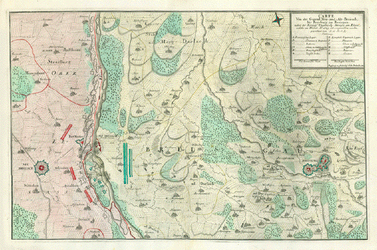
"Carte Von der Gegend Neu- und Alt-Breisach bis Freyburg im Breisgau, nebst der Koenigl. Ungarische Attaque am Rhein welche im Herbst Ao. 1743 ist vorgenommen worden" Copper etching by J.L.K.S.R (monogram) Published by Gabriel Bodenehr jun. (1705-1792) Augsburg, ca. 1750. This very detailed map was
published as a single sheet map. It was not bound in an
atlas. Map shows the confrontation and
fortifications on either side of the River Rhine Former map owner had folded the
map vertically and horizontally. 36,5 x 57,2 cm (ca. 14.4 x 22.5") $ 550.00 minus 30% Discount = $ 385.00) Order Nr. DEUTSCHLAND255382 |
|
"Prussiae Descriptioè" Hand-colored copper etching after the drawing by Heinrich Zell Published in "Theatrum Orbis Terrarum" By Abraham Ortelius /1527-1598) Antwerp, edition of 1595 A very early map. Good condition. Small crease (hardly visible) in lower area. Image: 30 x 19 cm (ca. 11.8 x 7.4") $ 160.00 minus 30% Discount = $ 112.00 |
|
"Circolo die Svevia diviso ne suoi Stati" Klarte von Baden-Wuerttemberg. Kurz vor der Säkularisation gehoerte das Land bis zum Lech noch dazu Type of print: Copper etching Color: Original outline hand coloring. Cartouche is originally hand-colored Author: Antonio Zatta Published: Venice, dated 1780 Condition: Very good. Light spotting and traces of age and use in wide margins. 30,7 x 40 cm (ca. 12 x 15.7") $ 160.00 minus 30% Discount = $ 112.00 Order Nr. DEUTSCHLAND239912 |
|
"Nouvelle Carte des Cercles De L'Empire, Avec Des Divers Souverains qui Component Des Dietes Et Ses Differents Coleges" Hand-colored copper etching by Henri Abraham Chatelain (1684-1743). Published 1720. Published in "Atlas Historique ou nouvelle introduction a l'histoire, a la chronologie & a la géographie ancienne & moderne" Amsterdam, 1705-1720. Map has detailed lists of the various empires on the right side. On the left side are lists of the many states in each region. Map image: 47 x 63 cm (18.5 x 24.8") Original coloring. Map has folds to fit in original atlas size. Map is in good condition with some light browning on fold lines and in margins.. In the lower left corner is a light crease in margin barely touching the text box. $ 280.00 minus 30% Discount = $ 196.00 Order Nr. DEUTSCHLAND257410 |
|
Hessen / Rheinland-Pfalz / NRW "Li Circoli Dell'Alto e Basso Reno" Karte zeigt Rheinlauf mit angrenzenden Landen von Philipsburg bis noerdlich Duesseldorf. Trier. Nord- und Sued-Hessen. Type of print: Copper etching Color: Original outline hand coloring. Cartouche is originally hand-colored Author: Antonio Zatta Published: Venice, dated 1780 Condition: Very good. Clean. Wide margins 30,7 x 40 cm (ca. 12 x 15.7") $ 160.00 minus 30% Discount = $ 112.00 Order Nr.DEUTSCHLAND239911 |
|
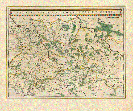
"Saxonia Superior, cum Lusatia et Misnia" Type of print: Copper etching by Willem Bleau. Published in Amsterdam ca 1640. Color: Beautiful original hand coloring Verso: Text in German about Saxony on one side and Meissen on the other side.. Vertical centerfold. In the center of the map is
Biscosswerd and Morgenstern. In the upper left is Magdeburg
and in the lower left is Hof and the Eger river . Condition: Light general age toning. Otherwise near perfect. Wide margins. 39 x 50.5 cm ( 15.3 x 19.8 ") Order Nr. DEUTSCHLAND237108SOLD |
|
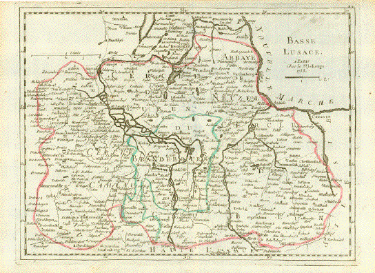
"Basse Lusace" (Niederlausitz, Lausitz) Copper engraving map with
original hand outline coloring. At the top of the map left is
Stockau. On the right is Crossen, Dobritz and Sorau. Map has a few signs of age and use mostly in margins. Vertical centerfold. 20.5 x 27.5 cm (8 x 10.8") $ 150.00 minus 30% Discount = $ 105.00 Order Nr. DEUTSCHLAND252599 |
|
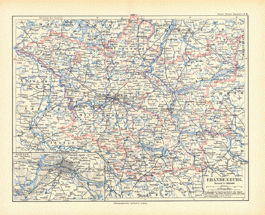
"Brandenburg" Very detailed map of Brandenburg published 1892. In the lower left is an inset of Berlin and surrounding area. Vertical centerfold. 21 x 26.5 cm ( 8.2 x 10.3 ") $ 45.00 minus 30% Discount = $ 31.50 Order Nr. DEUTSCHLAND249065 |
|
Vogtland, Thüringen, Sachsen, Franken, Böhmen (Tschechien), Gera, Greiz, Schleiz, Zwickau, Hof, Saalburg, Lobenstein, Weiße Elster, Saale, Göltzsch Vogtland. - "Delineatio Geographic Specialis Territorium Celsissimorum S.R.I Comitum Ruthenorum de Plauia untriusque Linea Senioris et Iunioris Partem Vogtlandiae opera et studio Joh. Gottlieb Schulzii S.C.M. Ing. Lieut. Accurate edita excedente Tob. Conrado Lotter Geographo Aug. Vindel." Altkolorierte Kupferstichkarte des Vogtlandes Von Georg Friedrich Lotter Erschienen bei Tobias Conrad Lotter (1717-1777) Augsburg, ca. 1750 Sehr guter Erhaltungszustand. Sehr attraktives Altkolorit. In der Titelkartusche eine Ansicht von Greiz. Der Lauf des Flusses Weiße Elster von Adorf bis Crossen. Der Lauf der Saale von Hof bis Obernitz. Die Herrschaften Gera, Greiz, Ebersdorf etc. Siehe Detail-Fotos. 57,5 x 49,5 cm $ 360.00 (Net liquidation sale / Netto Ausverkaufspreis) Order Nr. DEUTSCHLAND257565 |
|
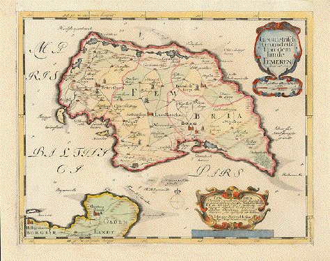
"Geometrisch. Grundriss von dem Lande Femeren anno 1648" Fehmarn, die drittgrösste deutsche Insel . Sehr detaillierte Karte mit Heiligenhafen und Grossenbrode auf dem Festland. Kupferstich aus dem Schlesweig-Holstein-Atlas von Johann Meyer. Husum, 1648. Sehr ansprechendem Handkolorit. The island of Fehmarn, Germany's third largest island. Very detailed map from the atlas by Johann Meyer. Husum, 1648 Copper etching. Very nice hand coloring. Alle vier Margen angesetzt. All four margins added. Die Darstellung in sehr gutem Zustand. Map itself very good condition. 23,2 x 30 cm (ca. 9.1 x 11.8") Order Nr. DEUTSCHLAND236826SOLD |
|
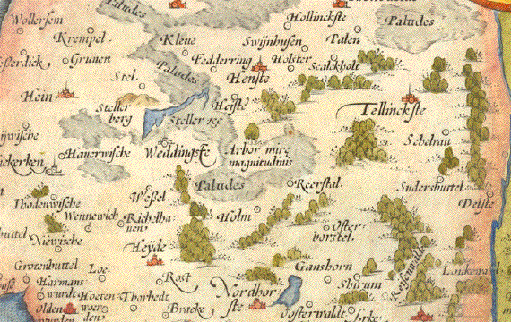
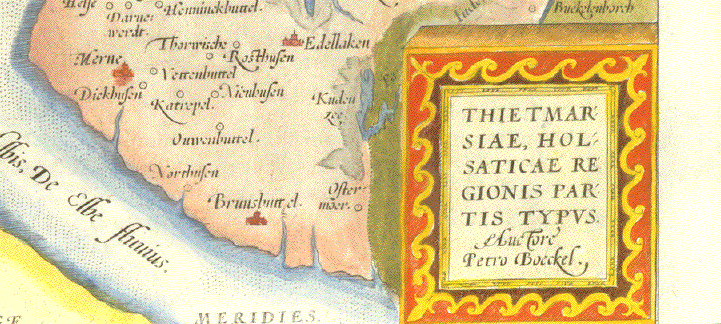
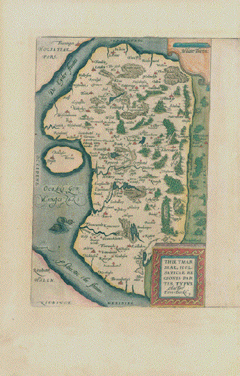
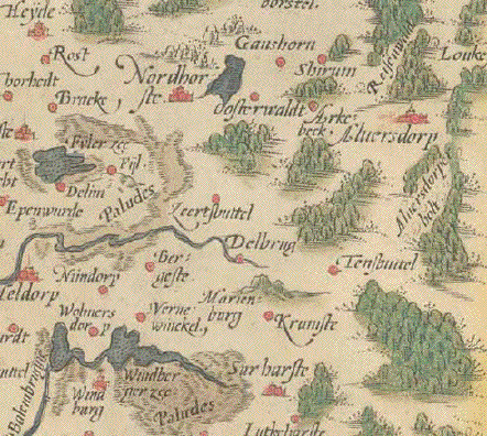
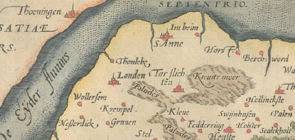
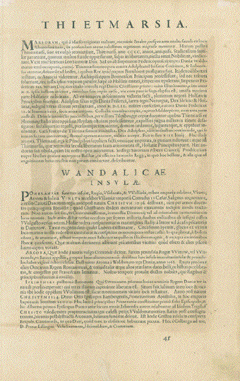
"Thietmarsiae, Holsaticae
Regionis Partis Typus Auctore Petro Boeckel" Antwerpen, 1581. Karte zeigt das Küstenland zwischen Elbe und Eider in der für diese frühen Atlanten typischen charmanten Renaissance-Art der Darstellung. Das "Theatrum Orbis Terrarium" von Abraham Ortelius war 1570 der erste jemals gedruckte Weltatlas. Die erste Ausgabe war klein, aber sofort erfolgreich, so dass Ortelius weitere Auflagen drucken liess. Gleichzeitig wuchs der Atlas. Jede neue Auflage enthielt auch neue Karten. Diese Karte von Dithmarschen wurde 1581 hinzugefügt. Sie hat im Atlas ein Gegenüber: Ostpreussen, das hier allerdings abgetrennt wurde. Sehr schön dichtes
handgeschöpftes Papier. Ausgezeichneter
Erhaltungszustand. 30.3 x 19.5 cm ( 11.9 x 7.6 ") Order Nr. DEUTSCHLAND252580SOLD |
|
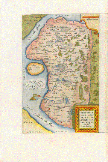
"Thietmarsiae, Holsaticae
Regionis Partis Typus Auctore Petro Boeckel" Antwerpen, 1581. Karte zeigt das Küstenland zwischen Elbe und Eider in der für diese frühen Atlanten typischen charmanten Renaissance-Art der Darstellung. Das "Theatrum Orbis Terrarium" von Abraham Ortelius war 1570 der erste jemals gedruckte Weltatlas. Die erste Ausgabe war klein, aber sofort erfolgreich, so dass Ortelius weitere Auflagen drucken liess. Gleichzeitig wuchs der Atlas. Jede neue Auflage enthielt auch neue Karten. Diese Karte von Dithmarschen wurde 1581 hinzugefügt. Sie hat im Atlas ein Gegenüber: Ostpreussen, das hier allerdings abgetrennt wurde. Handgeschöpftes Papier.
Klein Reparatur obere Marge. 30.3 x 19.5 cm ( 11.9 x 7.6 " Order Nr. DEUTSCHLAND255849SOLD |
|
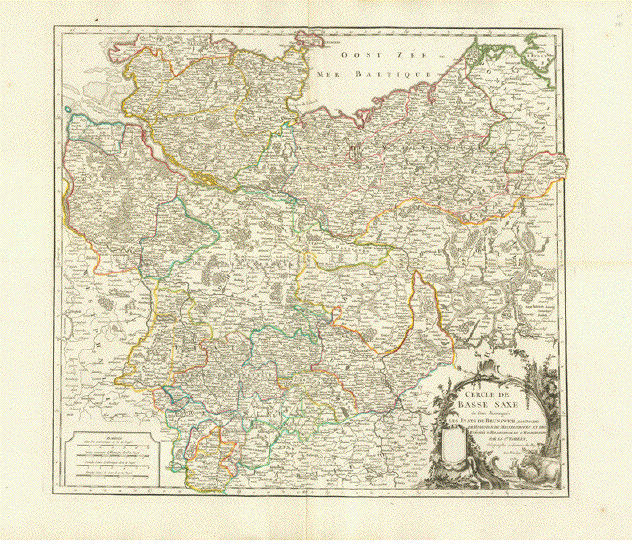
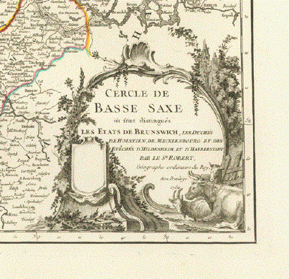
"Cercle de Basse Saxe ou sont distingues les Etats de Brunswich, Les Duches de Holstein, de Mecklenbug...." Copper engraving map by Robert Gilles de Vaugondy (1688-1766). Published in Paris 1752. Original hand-utline coloring. Map is in very goodd condition.
Very slght age toning on upper centerfold. Map image: 48 x 53.3 cm ( 18.9
x 20.9") $ 125.00 minus 30% Discount = $ 87.50 Order Nr. DEUTSCHLAND255258 |
|
Holstein Aus einer Fürstenausgabe. Prachtvolles Aktkolorit - Goldgehöht
PAAR Nordöstliches Holstein - Kartographie in Ausnahmequalität
"Nordertheil Uon Wageren Worinnen auch die amter Cißmar und Oldenborg. Anno 1649"
Prachtvoll altkolorierte Kupferstichkarte von A.L.Rothgiesser. Aus ÐAtlas Newe Landesbeschreibung der zwey Hertzogthümer Schleswich und Holstein" Aus dem Schleswig-Holstein-Atlas von Johannes Meyer (1606-1674). Publiziert bei Danckwerth in Husum, 1652
Mit mehreren altkolorierten, goldgehöhten Kartuschen. Der nördliche Teil von Wagrien. Stadtpläne von Lütjenburg, Heiligenhafen, Neustadt, Preetz und Plön. Die sehr dekorative Karte aus einer herausragend altkolorierten Fürstenausgabe zeigt das östliche Holstein, die Holsteinische Seenplatte. Karte reicht von Kiel bis Südspitze Fehmarn, im Süden vom Plöner See bis Neustadt
Nördl. Teil: 42 x 61 cm *************
***********
ÐLandtcarte vom Süderntheil des Wagerland's Und ein theil 'Stormaria', Worinnen daß Stifft Lubeck, das Fürstenthumb Plöen Und das Ambt Segeberg begriffen. Anno 1650"
Prachtvoll altkolorierte Kupferstichkarte. Aus ÐAtlas Newe Landesbeschreibung der zwey Hertzogthümer Schleswich und Holstein" Aus dem Schleswig-Holstein-Atlas von Johannes Meyer (1606-1674). Publiziert bei Danckwerth in Husum, 1652
Mit mehreren altkolorierten, goldgehöhten Kartuschen. Stadtpläne von Eutin, Segeberg, Schloss Segeberg und Travemünde. Zeigt den südlichen Teil von Wagrien. Im Norden vom Plöner See bis Neustadt, im Süden von Quickborn bis Lübeck.
Beide Karten in erstklassigem Erhaltungszustand. Beide Karten aus einer Hand. Ex Libris eines polnischen Wissenschaftlers auf den linken Rückseiten. Holstein Aus einer Fürstenausgabe. Prachtvolles Aktkolorit - Goldgehöht PAAR Nordöstliches Holstein - Kartographie in Ausnahmequalität
Nördl. Teil: 42 x 61 cm
Südl. Teil: 42 x 63 cm
Preis für das PAAR: $ 1900.00 (Nach 30% Discount: $ 1330.00)
Order Nr. DEUTSCHLAND 256965 |
|
Karte ohne Titel. Der Oderlauf von Crossen bis Frankfurt an der Oder. Sowie die ca. 40 Km Boberlauf bis zur Mündung in die Oder bei Crossen. Von den beiden Flußläufen westlich gelegenes Land bis Linie Mühlrose / Oberspreewald. Der schlesische Teil der Karte blanko. Altgrenzkolorierte Kupferstichkarte. Monogrammiert: J.V.J. Keine Titelkartusche, keine weiteren Hinweise auf Autor und Ort des Herausgebers. Erklärungen rechts in deutscher Sprache. Ca. 1750 Karte war 2 x horizontal und 3 x vertikal gefaltet. Reparaturen in den Falzen dilettantisch ausgeführt. Linke obere Marge angesetzt (mit Papier des 20. Jh.) Rechte Marge teilweise hinterlegt. - Ein Lazarettfall! Kartenmaß: 43 x 61 cm $ 380.00 minus 30% Discount = $ 266.00 Order Nr. DEUTSCHLAND256822 |
|
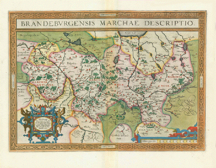
BRANDENBURG, POMMERN
"Tabula Marchionatus Brandenburgici et Ducatus Pomeraniae quae sunt Pars Septentrionalis Circuli Saxoniae Superioris" Altkolorierte Kupferstichkarte bei Johann Baptist Homann Nürnberg, 1723 Die Karte zeigt Brandenburg und Pommern. Barock-Kartusche - Sieben Putti halten Titel der Karte und die beiden fürstlichen Kronen und Wappen In den breiten Margen fleckig. Altersspuren. Aber sehr attraktive Karte. 42,5 x 53,5 cm (16.7 x 21") $ 400.00 (minus 30% discount = $ 280.00) Order Nr. DEUTSCHLAND256963 |
|
"Des Herzogthums Oberbayern Pflegerichte... oder des Rentamt München südlicher Theilè". Alt-flächenkolorierte Kupferstichkarte aus dem Atlas von Franz Johann Joseph von Reilly (1766-1820). Reilly wurde als Sohn des Hofmeisters Johann Reilly geboren. Zunächst arbeitete er im Staatsdienst, widmete sich dann aber ausschließlich der Geographie. 1789 bis 1806 entstand der Atlas Schauplatz der fünf Theile der Welt, der auf seinen 830 Blättern aber nur Europa behandelt. Erstklassiger Erhaltungszustand. 21,7 x 41 cm (8.4 x 16.1") $ 145.00 minus 30% Discount = $ 101,50 Order Nr. DEUTSCHLAND257130 |
|
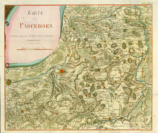
"Karte von Paderborn Zur Erleuterung eines auf diesem Terrain entworjenen." Copper engraving by J.F.W. Schleuen, ca 1680. Original hand coloring. Seldom. Almost in the center of the map is Paderborn. On the left side under the cartouche is Lippstadt. In the upper right is part of the Weser river with the towns of Kirchhofen, Hastenbeck and Tuender. In the lower right and bottom is the Diemel River with Stadtberg at the bottom of the map. Map has various folds to fit book size. A few spots in margins. Small thin spot in cartouche. Decorative map. 39.4 x 46.8 cm ( 15.5 x 18.4 ") $ 1100.00 minus 30% = $ 770.00 Order Nr. DEUTSCHLAND236970 Handkolorierte Kupferstichkarte von J.F.W. Schleuen. Ca. 1775 Seltene Karte des Weserlaufs von Rhoden / Wrexen (hier bezeichnet als Stadt Berg und Stadt Berge) entlang der Diemel Warburg, Libenau, Drendelburg, Helmershausen bis Carlshafen. Die Karte folgt dann dem Weserlauf bis zum Einfluus der Emmer bei Kirchhofen. Äusserster westlicher Punkt ist Lippstadt. Im Zentrum der Karte befindet sich Paderborn mit seiner sehr detailliert dargestellten nördlichen, östlichen und südlichen Umgebung. So finden sich auf dieser Karte kleine Orte wie geseke, Saltzkotten, Rhuden, Büren, Wimmenberg, Lichtenau, Kleinenberg, Borgentreich, Peckelsheim, Willebadessen, Borckholz, Gehrden, Dringenberg, Beverungen, Lippspringe, Driburg, Brackel, Nieheim, Breidenborn, Steinheim, Harn, Detmold, Vörden, Schwadenberg, Lugda und zwischen all diesen sogar noch jedes Dörflein. Auch der Verlauf des Alm-Flusses von seiner Quelle bis Lippstadt ist detailliert gezeichnet. Wälder, Berge, Bäche sind eingezeichnet. Eine sehr hübsche Karte, die wohl einem Buch enstammt. Sie sit mehrfach vertikal und horizontal gefaltet gewesen. Die Büge allerdings von vorne kaum erkennbar. Die Karte zeigt minimale Spuren von Alter und Gebrauch, ist allerdings sehr ansehnlich und gut erhalten. Original Falten. |
|
"Westfalia cum Diocesi Bremensi." Copper engraving by Gerard Mercator for Jodocus Hondius, ca 1630. Contemporary hand coloring. Oldenburg is right in the center of this map reaching from Ostfriesland on the left to Luneburg on the right size. In the upper right is a bit of the Elbe River. Backside has text (in French) about Westphalia. Map has smoothed centerfold with reinforcement along fold on backside. Left and right margin edges have repairs. Tiny piece missing on lower margin edge. Overall age toning and a few small spots in margins. 35.7 x 46 cm ( 14 x 18.1 ") $ 680.00 minus 30% Discount = $ 476.00 Order Nr. D1389 |
|
"Westfalia cum Diocesi Bremensi." Copper engraving by Gerard Mercator for Jodocus Hondius, ca 1630. Contemporary hand coloring. Oldenburg is right in the center of this map reaching from Ostfriesland on the left to Luneburg on the right size. In the upper right is a bit of the Elbe River. Backside has text (in French) about Westphalia. Printed on strong paper with wide margins. Map has vertical centerfold. Small repaired tear on centerfold on lower margin edge. Small repair on left margin edge. 35.7 x 46 cm ( 14 x 18.1 ") $ 520.00 minus 30% Discount = $ 364.00 Order Nr. D1388 |
|
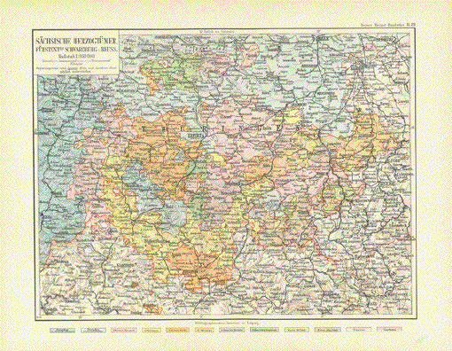
"Saechsische Herzogthuemer, Fuerstentmr Schwarzburg u. Reuss." Very detailed map with Rudolstadt in the center. Leipzig is in the upper right and Hammelburg and Schweinfurt in the lower left. Map published 1892. Verical centerfold. 20 x 26.5 cm ( 7.8 x 10.3 ") $ 55.00 minus 30% Discount = $ 31.50 Order Nr. DEUTSCHLAND249147 |
|
"Germaniae veteris typus". Copper etching by Wilhelm Janzoon Blaeu, Amsterdam, ca 1640. Recent hand coloring. This very attractive historical map of Germany was concepted after the map of Abraham Ortelius. It shows the area from the North Sea and Baltic Sea in the north to south of the alps and the Adriatic Sea in the south. In the west is Holland and the mouth of the Rhine. In the east is the Weichsel river. The towns and cities from the time of Charles the Great (8-9 centuries) are in the legend in the lower left and especially marked on the map. In the upper left is the title cartouche, in the lower right a cartouche giving mention that this map was made after one by Ortelius. Verso: Text in German. The map has light toning and repaired tears in upper and lower margins along center fold. There is a small repaired tear in the lower right margin corner as well as small reapaired tears in upper and lower margins. In the upper part of the map is a crease along the center fold. There is a spot in upper margins and one on the lower left margin. General condition is Almost Very Good. 37.8 x 48 cm ( 14.9 x 18.9 ") $ 520.00 minus 30% Discount = $ 364,00 Order Nr. DEUTSCHLAND1240 |
|
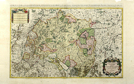
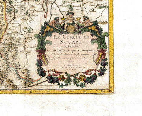
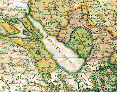
ÐLe Cercle de Souabe subdivise en tous les Etats qui le composent..." (Swabia, Germany). Copper etching by Nicolas Sanson. Published by Jean Covens and Cornelius Mortier. Amsterdam, ca. 1740. Excellent hand coloring. This very decorative, oversize map of Swabia reaches roughly from Colmar (Alsace) to Regensburg and from Rotheburg ob der Tauber to Lake Constance (and a liitle beyond). Lower right has the decorative title cartouche, upper left a multi-mileage scale. The individual principalities are named in text above image. Map is very clean. Because of its oversize it had to have several horizontal and vertical folds to fit atlas size. Very wide margins. Some traces of age and use. But generally, especially because of its superb color quality, this map ihas a very good appearance. Small piece missing on upper right margin edge. Image: 56 x 85.5 cm ( 22 x 33.7") Entire page: 66 x 108 cm ( 26 x 42.5") $ 1050.00 minus 30% Discount = $ 735.00 Order Nr. DEUTSCHLAND 1426 |
|
Course of the River Rhine from well to the North Sea. ÐDie erst Tafel innhaltend das Schweytzerlande - Die ander Tafel des Rheinstroms begreiffend die Pfaltz /( Westerreich / Eyfel/ et. - Die dritte Tafel des Rheinstroms unhaltend das Nioder Teutschlande" Woodcut from ÐCosmographia" by Sebastian Muenster. Basel, ca. 1550. Very attractively hand-colored. The river Rhein with all its tributeries from Switzerland, through the Western part of Austria, through France, Germany and Holland. The complete run of the Mosel river is a welcome side effect of this decorative maps into which Sebastian Muenster has also drawn mountains and forests. The three maps were meant to be and are joined together to form a long oversize wall map. Map has general age toning and, in margins, traces of age and use and a few spots. As this map is extraordinary in size, it has several vertical folds to fit the original book size. Reverse side has the three titles repeated. The overall appearance is very good and attractive. Ortder Nr. D EUTSCHLAND 1428SOLD |
|
"Allegmagne" Detailed map of Germany published ca 1890. On the reverse side is historical text about Berlin and Potsdam. Overall light natural age toning. Image: 19 x 25 cm ( 7.4 x 9.8") $ 25.00 minus 30% Discount = $ 17.50 Order Nr. DEUTSCHLAND257147 |
|
"Altgermanen und die Sued-Donau Laender um die Mitte des V (funf)ten Jahrhunderts. Copper engraving from Dr. Karl von Spruner's "Historisch-Geographischer Hand Atlas". Published in Gotha, 1846. Original hand outline coloring. This very historical map shows the area of the Old Germanen in the middle of the 5th Centery. The names on the map are very old Celtic, Latin and Old Germanic. Almost in the center of the map is "Maguntia" = Mainz. In the upper left corner is an inset of the area of the Franks about 550 AD. Map image is clean. In the beige outline and margins are scattered spots. Browning on outer margin edges. 32.5 x 37.5 cm ( 12.7 x 14.7 ") $ 170.00 minus 30% Discount = $ 119.00 Order Nr. DEUTSCHLAND1393 |
|
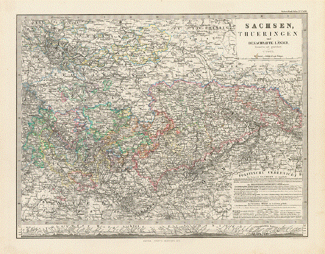
"Sachsen, Thueringen und Benachbarte Laender" Steel engraving by C. Vogel for
Stieler. Dated 1871. Very detailed map showing the political divisions of the time. These divisions are named and described in the inset in the lower right corner. At the bottom of the map is an interesting comparison of the mountain heights in the "Thueringer Wald, Fichtel Gebirge, Erz Gebirge and Elbsandstein Gebirge." Map has a small repair in lower margin on the centerfold. 31.2 x 40.5 cm ( 12.2 x 15.9 ") Order Nr. DEUTSCHLAND238366SOLD |
|
"Ducatus Brunsvicensis Fereque Lunaeburgensis". Copper etching by Nicolaes Visscher (1618-1679). Published ca 1675. Modern hand coloring. On the leftside of the map is the Weser River with the Steinhuder Meer in the upper left. In the lower left in Dahlheim in Hessen and in the upper right is Garleben on the Mildda River. In the lower right are Gorleben, Harras and Frankenhausen near the Helm River. On the right side are Halberstadt, Quedlingburg and Ascherstleben. Braunschweig is the largest red dot in the upper area. The centerfold on the map has been partially reinforced. Repairs on centerfold in upper and lower margins. Light browning along centerfold and minimal scattered spotting in margins. Condition is Much Better than Good. 41 x 52.5 cm ( 16 x 20.6 ") $420.00 minus 30% Discount = $ 294.00 Order Nr. DEUTSCHLAND 1300 |
|
"Mansfeldiae Comitatus Diligens et Acuratus Typus" Rare copper engraving map from
the atlas "Speculum orbis Terrae" by Gerard At the top of the map is Hall
and Bellenburg. On the left is Gersleben, Aschersleben and
Amsdorf. The map was scanned against a
black background that is not part of the map. A very fine and special map. Map image: 33 x 24.5 cm ( 12.9 x 9.6" $ 1300.00 minus 30% Discount = $ 910.00 Order Nr. DEUTSCHLAND256721 |
|
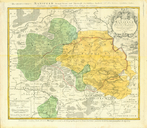
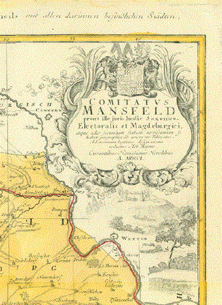
"Comitatus Mansfeld Prout ille juris hode Saxonico-Electoralis et Magdeburgiciè" Copper engraving map of Mansfeld Grafschaft. by Tobias Mayer for Homnn Erben.. Original hand coloring. Published 1750 in Nuremberg. Vertical centerfold. Heavy
paper. Map image: 45 x 54 cm ( 17.7 x
21.2") $ 240.00 minus 30% Discount = $ 168.00 Order Nr. DEUTSCHLAND256728 |
|
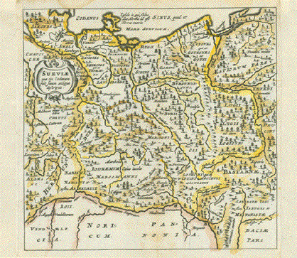
"Sueviae qui cis Codanum fuit finum antiqua descriptio"Copper etching by Philipp Clüver (1580-1622) Map of antique (Northern) Germany, falsely titled "Sveviaeè". The area shown is North of the river Danube to the Baltic Sea and from rivers Lech, Main, Weser in the West to what used to be East Prussia (now Poland) and to the Vistula (and a little beyond) in the East. The names of ancient German tribes are printed in. Clüver published his work on classic geography "Introductio in Universam Geographicam"in Amsterdam (1624-29). This map is fro the Clüver atlas published (post mortem) in Amsterdam, 1661 Copper etching with original borderline hand color. 12 x 12,5 cm (ca. 4.7 x 4.9") $ 80.00 (minus 30% = $ 56.00) Order Nr.DEUTSCHLAND256644 |
|
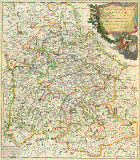
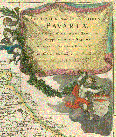
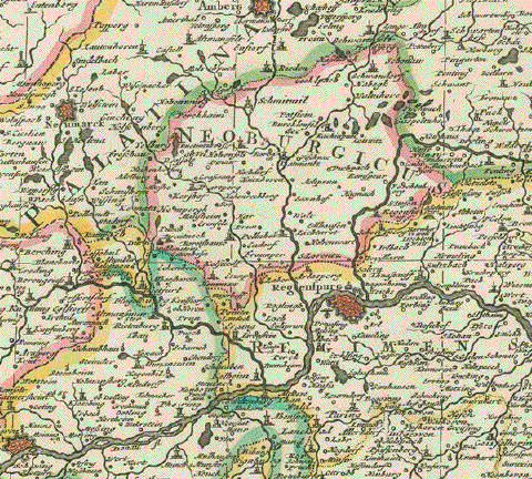
"Superioris ac Inferioris Bavariae Tabula Elegantissima Atque Exactissima Quappe et Annexae Regiones, Ditiones, ac Praefecturae Finitimae" Map of Bavaria within the borders of ca. 1800 including the region of Salzburg (which becameAustrian in 1816) Copper etching with original hand coloring. Published by Peter Schenk (1693-1775) Amsterdam, ca. 1750 Schenk's atlas had a small edition, so that his maps may be considered as mildly rare. 56 x 48,5 cm (ca. 22 x 19.1) Description: Very nice original hand coloring. Map had been mounted. There are rests of mounting glue visible along edges of reverse side of map. No signs of it on front side of map, however. Please look at scans. $ 680.00 (discounted at 30% = $ 476.00) Order Nr. DEUTSCHLAND256294 |
|
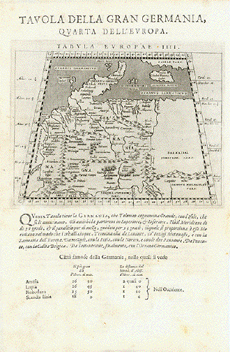
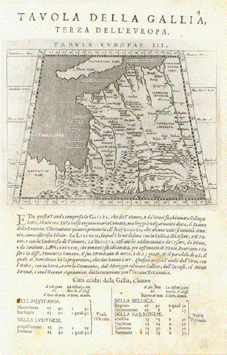
Reverse side:
ÐTavola della Gran Germania - Quarta dell'Europa" Map according to Ptolemy Type of print: Copper etching Artist: Girolamo Porro Published in: ÐGeografia cioe Descrittione Universale della Terra" Publisher: Gio. Battista & Giorgio Galignani Fratelli Edition: Italian edition Editor: Giovanni Antonio Magini (1555-1617) Text: Italian. Complete on front and reverse side Published in: Venice Date: 1598 Measurements: Map size: Ca. 12,5 x 17 cm (ca. 4.9 x 6.7") Page size: Ca. 28,5 x 19 cm (ca. 11.2 x 7.5") Reverse side: ÐTavola della Gallia" Map acording to Ptolemy Deatails as above for Germany Condition: Very good. Very minor traces of age. Price: $ 280.00 minus 30% Discount = $ 196.00 Order Nr.DEUTSCHLANDMAP238490 |
|
Weissensee, Sachsenburg, Thüringen, Thüringer Becken
"Derer zu dem Thuringischen Creisse des Churfürstenthums Sachsen gehöhrigen Aemter Sachsenburg und Weissensee richtige Delineation nebst allen andern angrenzenden Gegenden. In Amsterdam by Petrus Schenk èPrivilegie 1753" Altkolorierte Kupfertstichkarte von Peter Schenk Jr. (1693-1775) Amsterdam, 1753 Bestens erhaltene, detaillierte, wunderschön altkolorierte Karte von Weissensee und Sachsenburg und ihrer Umgebung. Die Karte reicht im Norden bis zum Kyffhäuser, im Osten bis Rastenberg, im Süden bis Erfurt, im Westen bis Marolterode. Deutlich eingezeichnet ist das Geflecht von Flüssen und Bächen in einem grossen Teil des Thüringer Beckens und auch kleine Ortschaften mit ihren im 18. Jahrhundert üblichen Namen. Links und rechts von dem geographischen Teil der Karte Liste der Ortschaften, Berge, Gewässer etc. Links unten die Titelkartusche, rechts unten Meilenanzeiger und Legendenschlüssel. Sehr attraktiv! 47,5 x 57 cm $ 450.00 (Net liquidation sale / Netto Ausverkaufspreis) Order Nr.DEUTSCHLAND257594 |
|
Altenburg, Ronneburg, Thüringen "Praefecturae Altenburgensis et Ronneburgensis earumque vicinia Serenissimo Duci Saxo Gothano parentes geographica tabula expressae a Matthaeo Seuttero Geograph. Caesar. Aug. Vindel" Altkolorierte Kupferstichkarte von Tobias Conrad Lotter (1717-1777) Erschienen bei Mattheus Seutter (1678-1757) Augsburg, ca. 1740 Sehr detaillierte Umgebungskarte der Städte Altenburg, Thüringen und Ronneburg, Thüringen. Im Norden reicht die Karte bis Lukas und Borna, im Osten bis Penig, im Süden bis südlich von Glauchau und Crimmitschau, im Westen bis Weida und Gerau. Sehr gut erhaltene Landkarte mit ausgezeichnetem Altkolorit. Im unteren Bereich Titelkartusche im barocken Stil. Links unten Meilenanzeiger. Ausserhalb der Karte links und rechts Ortsverzeichnisse mit Suchangaben zum Planquadrat. Margen oben und unten schmal. 49,3 x 58 cm $ 380.00 (Net liquidation price / Netto Ausverkaufpreis) Order Nr. DEUTSCHLAND257583 |
|
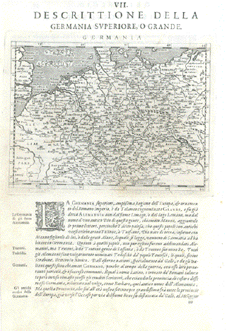
ÐDescrittione della Germania Superiore, O Grande" Maps shows all of Germany, Belgium, the Netherlands, Luxembourg, portions of France, Swizerland, Austria, The Czech Republic, Poland and Denmark, plus the SE corner of Great Britain. Type of print: Copper etching Artist: Girolamo Porro Published in: ÐGeografia cioe Descrittione Universale della Terra" Publisher: Gio. Battista & Giorgio Galignani Fratelli Edition: Italian edition Editor: Giovanni Antonio Magini (1555-1617) Text: Italian. Complete on front and reverse side Published in: Venice Date: 1598 Reverse side: Has text print about West- and East-Frisia Measurements: Map size: Ca. 12,5 x 17 cm (ca. 4.9 x 6.7") Page size: Ca. 28,5 x 19 cm (ca. 11.2 x 7.5") Condition: Near perfect. Very minor traces of age. Price: $ 250.00 minus 30% Discount = $ 175.00 Order Nr. DEUTSCHLAND238492 |
|
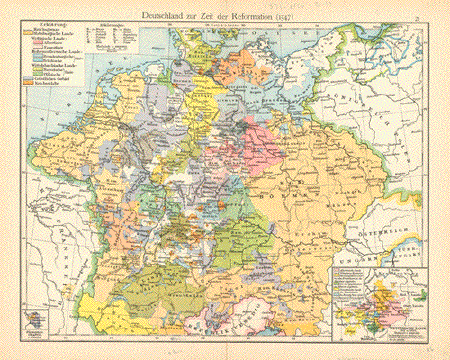
"Deutschland zur Zeit der Reformation (1547)" Very informative map of Germany
at the time of the Reformation. Published 1896. In the lower
left is a small Small repair in lower margin on centerfold. 22.5 x 29 cm ( 8.8 x 11.4 ") $ 50.00 minus 30% Discount = $ 35.00 Order Nr. DEUTSCHLAND248718 |
|
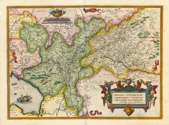
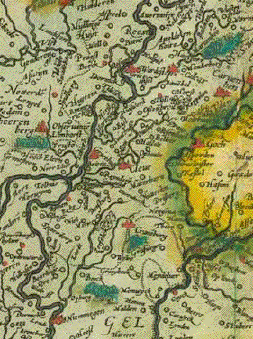
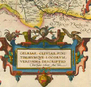
"Geldriae, Cliviae, finitimorumque Locorum verissima Descriptio" Attractively hand-colored copper etching by Christian Schrot. Published in "Theatrum Orbis Terrarum" by Abraham Ortelius (1527-1598) Antwerpen, 1570. This map, from the 1584 edition. Verso text in Latin. Lower centerfold a tiny bit wrinkly. Very minor signs of age and use. 36,7 x 50 cm (ca. 14.4 x 19.7") $ 740.00 minus 30% Discount = $ 518.00 Order Nr. DEUTSCHLAND248363 |
|
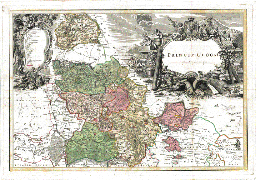
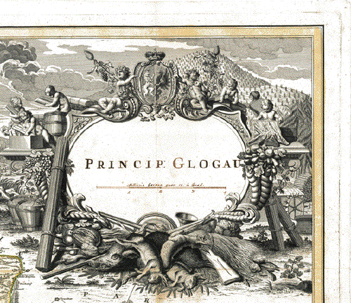
PROBEABZUG vor dem noch zu stechenden Titel- PROOF PRINT (before Title) "Princ. Glogau" Fürstentum Glogau (Oberschlesien) Sehr detaillierte und dekorative handkolorierte Kupferstichkarte nach Zeichnung von Johann Wilhelm Wieland (? - 1736) und nach dessen Tod ueberarbeitet von Matthaeus Schubart (? - 1758). Aus dem "Atlas Silesiae". Herausgeber: Homann Erben, Nürnberg. Die Karte ist 1736 datiert und gedruckt. Der Atlas mit insgesamt 18 Kupferstichkarten ( zwei Übersichtskarten und 16 Fürstentuemer) im Gross-Folio-Format wurde insgesamt aber erst 1750 herausgegeben. Das Besondere dieser Karte ist: Sie wurde als Probedruck vor dem gestochenen Titel abgezogen. In der Titelkartusche die Worte: Princ. Glogau und das Meilenmass von Hand mit Tinte geschrieben. Karte hat zwei zusaetzliche vertikale Faltungen und eine horizontale Mittelfaltung. Sie ist auf Leinen aufgezogen und hat nur minimale Alters- und Gebrauchsspuren. Principality of Glogau (Glogowek). Hand-colored copper etching after the drawing by Johann Wilhelm Wiegand (? - 1736) and, after his death, revised by Matthaeus Schubarth (ß - 1758). Published in the "Atlas Silesiae". Published by Homann Heirs in Nuremberg. The map is dated and printed in 1736, although the complete atlas with 18 grand-folio-size maps was published in its entirety in 1750. This very large map shows much detail. Even small villages are mentioned. Principality Glogau i Upper Silesia). Very detailed and very decorative cartouches and hand coloring. Proof print. Title and mileage measure in ink hand writing. Additional vertical folds and a horizontal centerfold. Map was mounted on linen. Hardly any traces of age and use. Lower margin narrow. 55,3 x 81,4 cm (ca. 21.8 x 32") Order Nr.DEUTSCHLAND248610 SOLD |
|
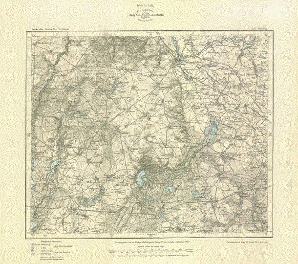
"Wriezen". "Herausgegeben von der Kartogr. Abtheilung der Königl. Preuss. Landes-Aufnahme 1893" Lithographie. Kartennummer 270 Erhaltungszustand: Gut. Die
Seen in blau gedruckt. Leichte Altersbräunung. Karte
wurde einmal horizontal und zweimal vertikal gefaltet. Abmessungen: Karte: 29 x 35 cm. Blattgröße: 38 x 42,5 cm. $ 55.00 minus 30% Discount = $ 38.50 Order Nr. DEUTSCHLAND256408 |
|
"Ducatus Slesvicensis in omnes suas Praefecturas Circulos et Provincias." Copper engraving by Frederick De Wit (1630-1706). Published ca 1680. Original hand coloring. The northern part of the map shows southern Denmark . On the upper part of the map are the Danish towns of Colding and Rypen. In the lower part of the map is the mouth of the Eider River on the left. Kiel is in the lower right. Map has vertical centerfold. A few scattered spots, mostly in the margins. Condition is Much Better than Good. 49 x 56.5 cm ( 19.2 x 22.2 ") $ 580.00 minus 30% Discount = $ 406.00 Order Nr. DEUTSCHLAND1379 |
|
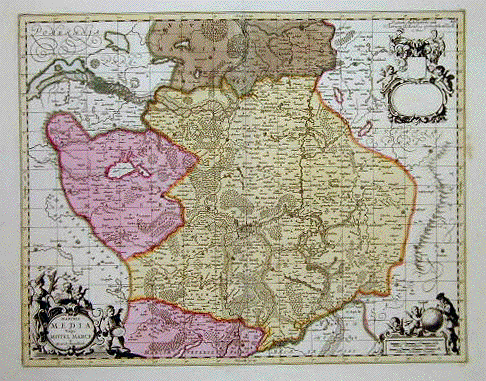
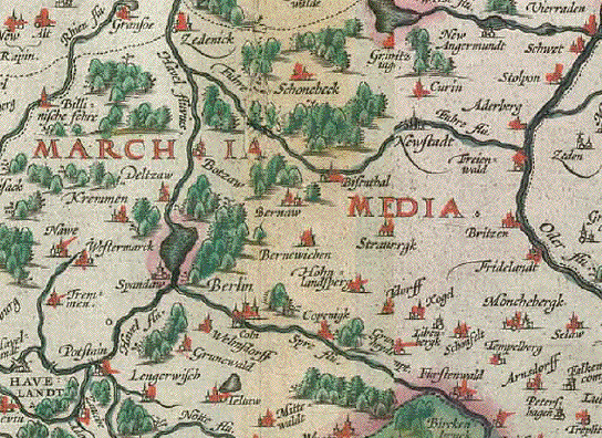
"Marchia Media. Vulgo Mittel Marck in March:Brandenburg:" Copper etching by Peter Schenk and Gerard Valck. Published in Amsterdam, 1708. Original hand coloring. The map shows the region surrounding Berlin, which is in the center of the map. It reaches as far north as Stettin. Also shown on the map is part of the Ückermark. Map has light age toning and a spot in right margin and another under the cartouche in lower left. Overall condition is Almost Very Good. 39.5 x 50 cm (15.5 x 19.6 ") $ 440.00 minus 30% Discount = $ 308.00 Order Nr. DEUTSCHLAND1291 |
|
"Mappa geographica exibens electoratum
Brandenburgensem, sive Marchiam Veterem, et Novam nec Mark Brandenburg with Berlin in the center
is the central theme of this map. The area shown extends
from Magdeburg in the Map has overall light toning and some browning along the center fold. A tear in the lower part of the fold has been repaired. The lower margin corners are smudges and there are some some scattered spots on the map. The town of Clötzen in the lower left part of the map has a red circle around it. General condition is Almost Very Good. 49.9 x 57.5 cm ( 19.6 x 22.6 ") $ 520.00 minus 30% Discount = $ 364.00 Order Nr. DEUTSCHLAND1230 |
|
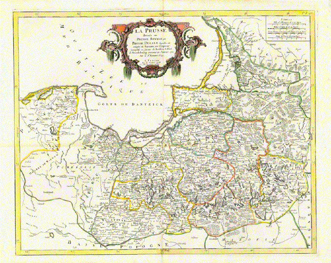
"La Prusse divisée en Prusse Royale et Prusse Ducalè" Copper etching with original borderline hand color. By Gilles Robert de Vaugondy (1723-1786) Published by Paolo Santini in Venice, 1778 Very detailed map of East
Prussia (now Poland for the most part, the northern Vertical centerfold. A few very minor signs of age and use. 48,5 x 61 cm (ca. 19 x 24") $ 1200.00 (Discounted at 30% = $ 840.00) Order Nr. DEUTSCHLAND256214 |
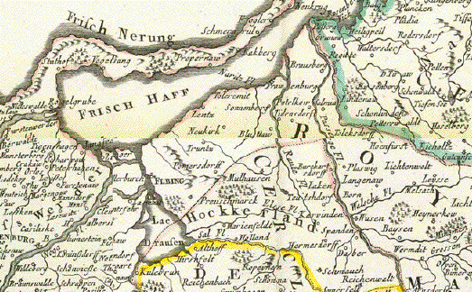
"Brandeburgensis Marchae Descriptio"
Hand-colored copper engraving.
Published in ÐTheatrum Orbis Terrarum" by Abraham Ortelius (1527-1598)
Verso: Text in Latin
Antwerp, 1588
Very good condition. Beautiful exemplar!
Very, very attractive map with Berlin, the German capital, directly in the center. The map is beautifully and richly adorned with a surrounding decorative bordure and a very attractive Renaissance title cartouche.
The typical 16th century hand coloring is making this map a most beautiful wall decoration.
Map reaches from Wittenberg on the Elbe downstream to near Lauenburg on the Elbe river. We find "Frisch he Haff near Stettin on this map as well as Neu Mark, Spreewald. Throughout the map we see a multitude of rivers and smaller waterways, like veins, meandering through the landscape giving this map structure. Asked for my opinion I wouldd say: This is definitely one of the most decorative prints from the first world atlas .
Sehr attraktive Landkarte der Mark Brandenburg mit der Hauptstadt Deutschlands, Berlin, direkt in der Mitte.Die umlaufende Borduere und die Renaissance-Kartusche, sowie das sehr attraktive Handkolorit im Renaissance-Stil und das Geaeder zahlreicher Fluesse geben der Karte einen hohen Dekorationswert als Wandschmuck. Die Karte reicht vom Stettiner Haff im Norden bis Wittenberg und der Lausitz im Süden, von der VW-Stadt Wolfsburg im Westen bis zum Trage-Fluss im Osten.
Sehr guter Erhaltungszustand. Sehr attraktives Exemplar.
Map image: 35,3 x 49 cm (ca. 13.9 x 19.3")
$ 850.00 (Please look for discount at top of this page. Here 30% = $ 595.00)
Order Nr. DEUTSCHLAND266873
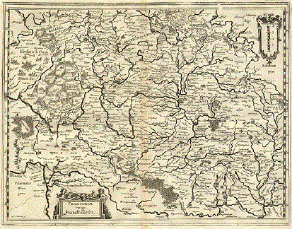
"Franconia vulgo Franckenlandt". Copper etching by Matthaeus Merian, 1637.
This early map shows all of present-day Franconia. In the northeast is the Saale river and in the nothwest is the city of Marburg in Hesse. Left of the title cartouche is the Neckar river and Heilbronn. In the southeast is the confluence of the Altmühl river and Danube river. The river system of Franconia is very detailed on this map. The name "M. Merian" is in lower left corner.
Map impression is very clear and clean. Right and left margins are a bit narrow.Some light, scattered spotting in margins and a tiny bit in the upper image corner. Along the centerfold is typical browning. Small repair on upper margin edge. General condition is Almost Very Good.
Size measured on outer line: 27.2 x 35.5 cm ( 10.7 x 13.9 "9
$ 100.00 minus 30% Discount = $ 70.00
Order Nr. DEUTSCHLAND 1246
"Meklemburg Ducatus". Copper etching by Matthaeus Merian, 1637.
Map shows the former area of Mecklenburg. In the upper right is part of the island of Rugen. On the left is Travemunde and in the lower left is part of the Elbe river near Bulow. Notice the many lakes in the center of the map which make this area well known.
Map has light browning along centerfold.A few spots in margins and a crease in upper margin. Condition is Better than Good.
19.3 x 25. cm ( 7.6 x 9.8 ")
$ 100.00 minus 30% Discount = $ 70.00
Order Nr. DEUTSCHLAND 1314
"Misnae et Lusitatiae Tabula". Copper etching by M. Bartholomaeo Sculteto Gorlit (1540-1614) for "Theatrum Orbis Terrarum" by Abraham Ortelius. Antwerp. Later hand coloring. Published ca 1580.
This map is east-oriented. East is at the top and north on the left side. In the upper left is a bit of Silesia with the confluence of the Neisse River in the Oder River. In the upper right is Prague on the edge and in the lower right is Fichtelgebirge. At the bottom center is Gotha. Meissen is in the center of the map.
Left margin is browned and has been reinforced. The other three margins are wider. Right margin has light brown water stain the reachers into upper margin. Small repair on lower left margin corner. General condition is Much Better than Good for a map this age.
29 x 21 cm ( 11.4 x 8.2 ")
$ 350.00 minus 30% Discount = $ 245.00
Order Nr. DEUTSCHLAND 1315
|
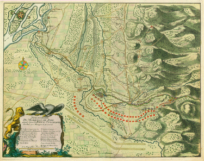
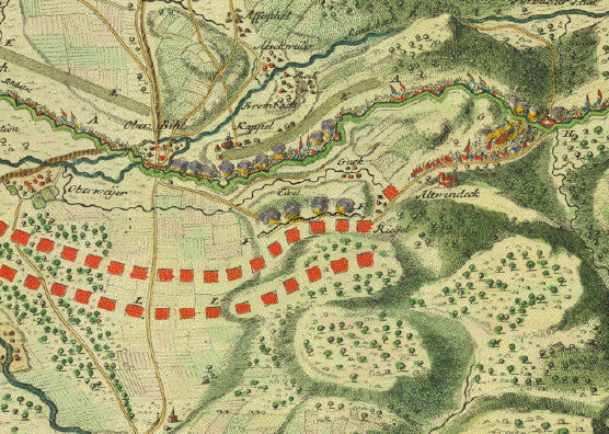
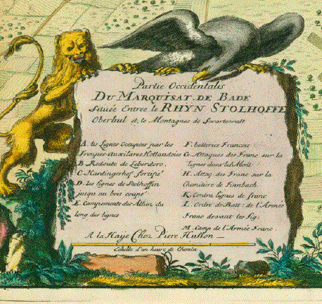
"Partie Occiendentalis Du Marquisat de Bade située Entree le Rhyn Stolhoffen Oberbul et le Montagnes de Swartewalt" Hand-colored copper etching by Pierre Husson. This map was published as a single sheet map, not bound in an atlas. Title and explanatory cartouche is held by a lion and an eagle. The lion is the Royal Dutch Lion, the Eagle Den Haag, The Netherlands, 1703 We are looking here at the border region between France and Germany, more precisely between Elsace and the State of Bade-Wurttemberg. In the upper left corner of this map we have a stretch of the River Rhine, with Fort-Louis, actually the only piece of France (Elsace). The larger rest of the map shows a very detailed area of Bade in Germany in the War of Spanish Succession. Vertical on the right we see the Western part of a section of the Black Forest. In the center of this map we see Stollhofen with the fortifications, built by Ludwig Wilhelm Ist of Baden. The situation in the year 1703. This map was issued without a centerfold. A former owner, however, has folded it for easier keeping. There is at the bottom ca faint crease.A few parallel creases on centerfold. 41 x 52 cm (ca. 16.1 x 20.5") $ 480.00 (Please look for discount at top of this page. Here 30 % = $ 336.00) Order Nr.DEUTSCHLAND255381 |
|
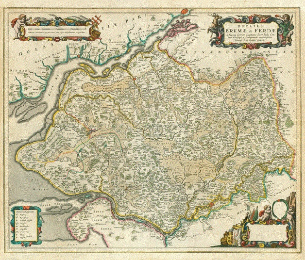
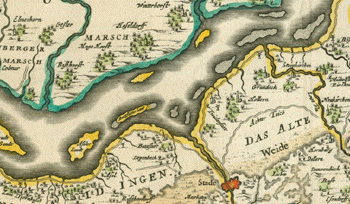
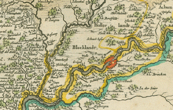
"Ducatus Bremae & Ferdae a Ionne Gorries Capitaneo Sueco Jusu Com. ". Copper engraving by Ioan Christoph a Coningsmarck, ca 1660. Special hand coloring with gold accents. Along the bottom of the map we see part of the course of the Weser River as far as the confluence with the Aller River near Verden. In the Upper left is the mouth of the Elbe River. At top center of the map is Hamburg. On the everse side is text (Latin). Map has a vertical centerfold. Right and upper margins have been added. Heavy paper. 50.5 x 62 cm ( 19.8 x 24.4 ") $ 1200.00 minus 30% Discount = $ 840.00 Order Nr. D1387
|
|
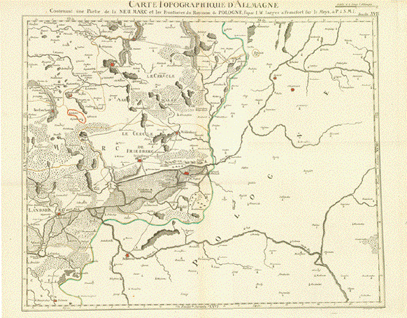
" Carte Topographique d'Allmagne Contenant une Partie de la Neu Marc et les Frontieres de Pologne" Copper engraving with original
borderline coloring. Engraved by Berndt and published by In the center of the map is
Driesen. Landsberg/Warthe is on the left. In the upper right
and Vertical centerfold. A few
words written in ink on reverse side in lower margin. Map image: 46.5 x 58.5 cm ( 18.3 x 23 ") $ 350.00 minus 30% Discount = $ 245.00 DEUTSCHLAND249957 |
|
"Parte Meredionale del Circolo dell'Alta Sassonia" Map of Sachsen-Anhalt and Sachsen Type of print: Copper etching Color: Original outline hand coloring. Cartouche is originally hand-colored Author: Antonio Zatta Published: Venice, dated 1780 Condition: Very good. Clean. Wide margins 30,7 x 40 cm (ca. 12 x 15.7") $ 160.00 Order Nr. DEUTSCHLAND239914 |
|
"Confederation Germanique Royaume de Prusse Empire D'Autriche Royaume de Pologne" Map shows the various divisions of Europe at the time. Copper engraving by F.
Delamarche dated 1828. Published in his atlas in 1832. Vertical centerfold. Small repairs in margins on centerfold. Light creasing on right side. 27.5 x 36 cm ( 10.8 x 14.1 ") $ 40.00 Order Nr. EUROPEMAP242279 |
|
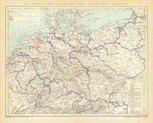
"Die Schiffahrtsstrassen des Deutschen Reiches" This map shows the routes of
shipping in Germany, Holland,Poland and the Baltic States in
1895. 20 x 27 cm ( 7.8 x 10.6 ") Order Nr. DEUTSCHLAND244482 SOLD |
|
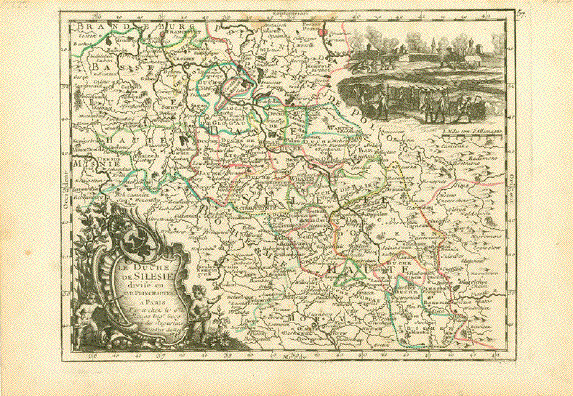
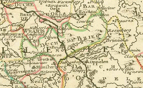
"Le Duché de Silesie divise en XVII Principautees" Copper etching by George Louis Le Rouge (1707-1790) Published in ÐL'Empire D'Allemagne - Divise par Cercles" Paris, 1743 It was the year (1743) of the Prussian-Russian Alliance Treaty, when this map is dated. Prussia was in the middle between the first and the second Silesian War, at the end of which (1745) Austria (to which Silesia belonged) lost Silesia which became a Prussian province thereafter. Map showing Upper and Lower Silesia during the two Silesian Wars, just briefly before all of Silesia became e Prussian province under King Friedrich II. Of Prussia. Light age toning and minor spotting in margins. Borderline original hand-color. Image: 20 x 26,3 cm (ca. 7.8 x 10.3") $ 150.00 (Please look for discount at top of this page. Here 30% = $ 105.00). Order Nr. DEUTSCHLAND254820 |
|
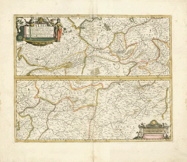
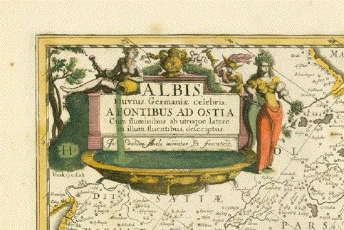
"Albis, Fluvius Germaniae celebris a Fontibus ad Ostia........." This copper engraving map shows
the entire course of the Elbe River from its The cartographs of this detailed map were Peter Schenk and Gerard Valk after Johann van den Avelen ( 1655-1727 ). The map was published ca 1700. Attractive original hand coloring. Copper engraving. Vertical centerfold that has been reinforced on the reverse side. Repair in lower margin on centerfold. Upper margin edge has been reinforced. Some light spotting in margins. Map image: 39 x 48.5 cm ( 15.3 X 19 9 ") Copper engraving. Vertical
centerfold that has been reinforced on the reverse side. $ 350.00 Order Nr. DEUTSCHLAND251701 |
|
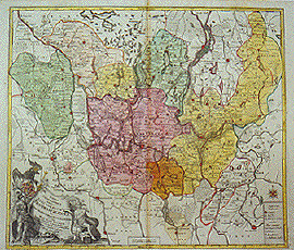
"Partie Sept.le du Cercle de
la Haute Saxe, divisée par ses
Principautés. Copper etching by Robert de Vaugondy (1723-.1786) Very attractive original hand color Paris, 1749 Published in "Atlas portatif universel et militaire, Paris, Durand & Pissot" by Vaugondy Clean. Wide margins Mecklenburg und Pommern, sowie
Nord-Brandenburg bis Berlin. Sehr attraktiv altkolorierte Kupferradierung von Robert de Vaugondy (1723-.1786) Aus: "Atlas portatif universel et militaire, Paris, Durand & Pissot" von Vaugondy Paris, 1749 Sauber. Breitranding. 16,3 x 21 cm (ca. 6.4 x 8.2") $ 180.00 (Please look for discount at top of this page. Here 30% = $ 126.00) Order Nr. GERMANY254536 |
|
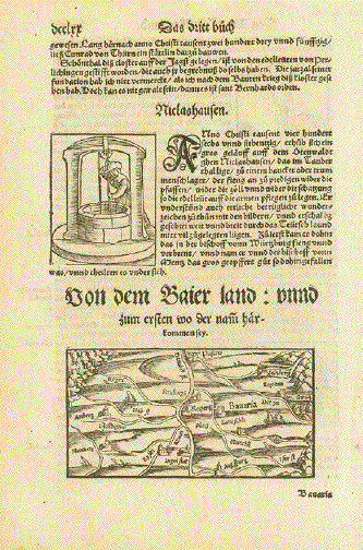
ÐVon dem Baier land: unnd zum ersten wo der nam haerkommen sey" Small east-oriented map of Bavaria. Woodcut. Published in ÐCosmographia" By Sebastian Muenster (1488-1552) Published in Basel, 1553 On the whole page. Very good
condition. Light general age toning. Map size: 7 x 13,5 cm (ca. 2.8 x 5.3") Page size: 31 x 20,5 cm (ca. 12.2 x 8") $ 80.00 (Please see discount at top of this page. Here 30% = $ 56.00). Order Nr. DEUTSCHLAND254704 |
|
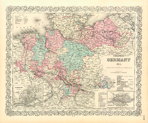
"Colton's Germany No. 1" Type of print: Lithograph Color: Original hand coloring Publisher: George W. Colton Published in: "Colton's Atlas of the World illustrating physical and political geography" Published: New York, 1856 Map basically includes North Germany. The colored part as far east as Mecklenburg. West: To the Dutch border. South: To Lower Saxony. Two insets: "Hamburg" and "Bremen" A decorative bordure frames this attractive map. Condition: Light general age toning. Very attractive, bright colors. . Reverse side is blank. 32 x 39,5 cm (ca. 12.6 x 15.6") $ 80.00 Order Nr. DEUTSCHLAND 239545 |
|
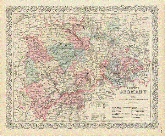
"Colton's Germany No. 2" Type of print: Lithograph Color: Original hand coloring Publisher: George W. Colton Published in: "Colton's Atlas of the World illustrating physical and political geography" Published: New York, 1856 Map basically shows Central Germany. North: Westphalia, southern Lower Saxony. East: Saxonia. Soiuth: Franconia. West: To the borders of The Netherlands, Belgium, Luxembourg and the north-eastern corner of France.A decorative bordure frames this attractive map. Condition: Light general age toning. Very attractive, bright colors. . Reverse side is printed. 32 x 39,5 cm (ca. 12.6 x 15.6") $ 80.00 Order Nr. DEUTSCHLAND 239549 |
|
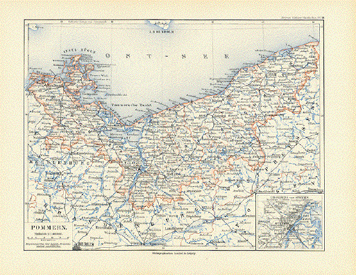
ÐPommern" Pommerania Published in Meyers Kleiner Handatlas. Leipzig, 1892 Very few minor traces of age and use. Vertical centerfold 20 x 26.4 cm (7.9" x 10.4") $ 60.00 Order Nr. POLANDMAP237909 |
|
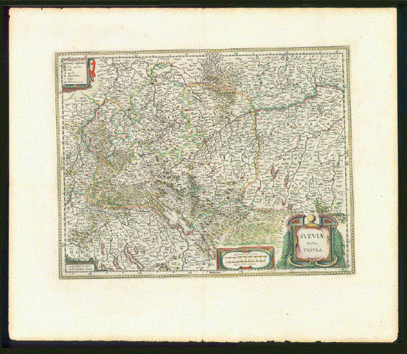
"Sveviae Nova Tabula" Copper engraving map of Swabia (Schwaben). Very detailed map by Wilhelm Bleau with Ulm, Memmingen and Federsee in the center. The map was published in Amsterdam in 1641 and has Dutch text on the reverse side. Attractive hand coloring. The map has minor creasing
along centerfold in lower margin. Small repair on lower
centerfold. Scanned on black background. Map image: 37. x 48.5 cm ( 14.7 x 19 ") Order Nr. DEUTSCHLAND254248 SOLD |
|
***** Reverse side:
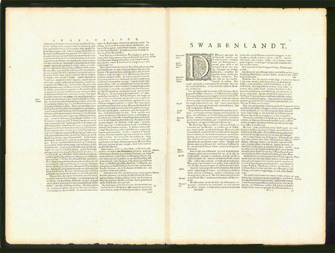
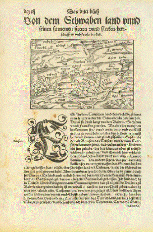
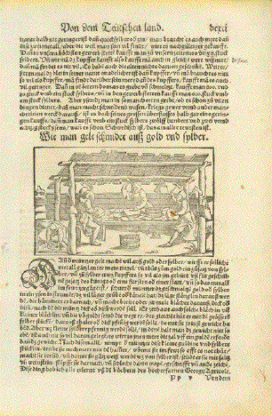
"von dem Schwaben land unnd seinen fuernemen Stätten unnd flecken / herrschafften und Fruchtbarkeit" Woodcut framed from Nuremberg, Ansbach, Augsburg, Memmingen, Lindau, Lake Constanz, Zuerich, Basel Strasbourg, Speyer, Worms, Mainz and the run of the river Main. Black Forest in center of map. Published in "Cosmographia" by Sebastian Muenster (1488-1552) German edition. Basel, 1553 Above and below map and on reverse side title and text in German Reverse side has woodcut about gold and silver production. General age toning. a few foxing spots. Basically very good condition. Map: 9 x 13,4 cm (ca. 3.5 x 5.3") Gold and silver production: 7,7 x 13 cm (ca. 3 x 5.1") Page size: 30,5 x 20 cm (ca. 12 x 7.9") $ 130.00 Order Nr. DEUTSCHLAND254482 |
|
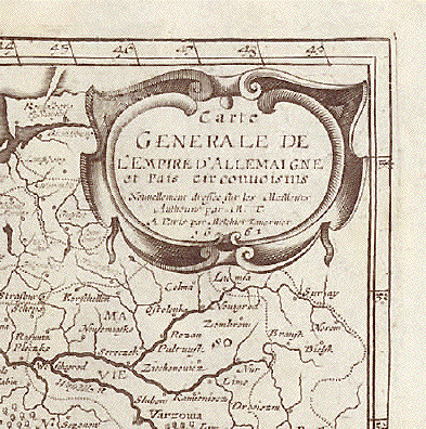
"Carte generale de l Empire d Allemaigne et Pais circonvoisins" Copper engraving map by M. Tavernie. Pubished at Pierre Davity, Paris, 1661 Engravings from topographic works by Davity are very rare! Vertical centerfold. Margins
with creasing show signs of age and use. Image: 31 x 37 cm (12.4 x 14.5") Page size: ca. 36,5 x 40,5 cm (14.3 x 15.9") $ 320.00 Order Nr. DEUTSCHLAND255152 |
|
"Mappa geographica exibens electoratum
Brandenburgensem, sive Marchiam Veterem, et Novam nec Mark Brandenburg with Berlin in the center
is the central theme of this map. The area shown extends
from Magdeburg in the Map has overall light toning and some browning along the center fold. A tear in the lower part of the fold has been repaired. The lower margin corners are smudges and there are some some scattered spots on the map. The town of Clötzen in the lower left part of the map has a red circle around it. General condition is Almost Very Good. 49.9 x 57.5 cm ( 19.6 x 22.6 ") $ 520.00 Order Nr. DEUTSCHLAND1230 |
|
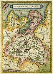
"Oldenburg comit ." Copper etching by Laurentius Michaelis. From the atlas "Theatrum Orbis Terrarum" by Abraham Ortelius, ca 1600. Absolutely beautiful map of the county of
Oldenburg reaching from the North Sea with the island of
Wangerooge as far south as The map has general toning and some minor spots. Left margin has some this spots, invisible from front. Otherwise near excellent. 34 x 23.5 cm (13.4 x 9.3") $ 280.00 Order Nr. DEUTSCHLAND1199 |
|
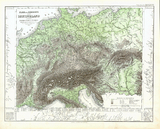
Fluss und Bergkarte von Deutschland und den Anliegenden Laendern Steel engraving designed by Adolf Stieler in 1820. Published in Gotha 1871. This very detailed map shows the mountains and rivers of Germany and surrouding countries. Various shades of green and brown show the elevations. On the sides and lower edge are elevations of various mountains. Map has very light age toning on margin edges. Vertical centerfold. Good condition. 32.5 x 41 cm ( 12.7 x 16.1 ") $ 50.00 Order Nr. DEUTSCHLAND236675 |
|
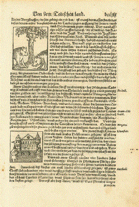
"Germanicae Nationis Descriptio" Hand-colored woodcut. Published in "Cosmographia" By Sebastian Muenster. Basel, ca. 1550 This map is especially charming and interesting because of its south orientation. This "upside-down" look was not totally uncommon in the 16th century (we know also west- and east-oriented maps) as the north orientation of maps was discussed and became the "normal" depiction in the 17th century, at a time when more atlases, charts and maps were produced. This map of Germany extends from Lübeck to Brixen (Bressanone) and from Antwerp to Danzig (Gdansk). With Bohemia often shown like the heart of Europe surrounded by a heart-shaped belt of forests. A little creasing in lower left corner and for the most part in margins outside image. Reverse side has brief description of Germany in Latin. This map is one of the earliest of Central Europe. On the right a mileage scale from 0 to 130. Ca. 26,7 x 34,3 cm (ca. 10.5 x 13.5") Order Nr. DEUTSCHLAND242277 SOLD |
|
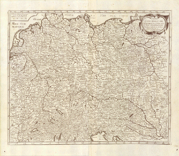
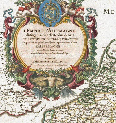
"L'Empire D'Allemagne distingue suivant l'estendue de tous Les Etats, Principautes, et Souverainetes qui passent ou qui ont passe jusque a present sous le nom d'Allemagne sur les Memoires les plus Nouveaux par le Sr. Sanson Geographe Ordinaire du Roy, presente a Monseigneur Le Dauphin Par Son tres humble, tres obeissant, et tres fidele Scruiteur H. Jaillot". Copper etching by Sansson. Published y Hubert Jaillot. Original hand coloring.Paris. Dated 1706. This large wall map of ÐGermany" with two richly adorned cartouches is really a map of Central Europe. It extends from the Normandie to Warsaw and Belgrade and from Germany's coastlines of the North Sea and the Baltic Sea to the Northern Italian Lake region and the Gulf of Venice. General age toning. Margins have some spotting. Left half of map has extra vertical fold. Two little wormholes in centerfold have been repaired. Otherwise map is in very good condition. 58 x 88.6 cm (22.8 x 34.9") Order Nr. DEUTSCHLAND248619 SOLD |
More Maps of Germany (Page 2) - Mehr Landkarten von Deutschland (Seite 2)
|
© Rainer Rauhut
|