|
Alte Landkarten von Deutschland (Seite 8) Antique Maps of Germany (Page 8) This is a selection of our historical maps of Germany. There are several pages more. Click the link at the bottom of the page to see more. If you are looking for a particular map please contact us. If you want to know if a certain town or city is on one of our maps, please ask. Sale! Discount! 30% Discount on All maps with a DEUTSCHLAND number on this page! Take 30% off the listed price. ! We accept offers! Visit us at the following sites: https://lovelyantiqueprints.com twitter.com/philographikon2 |
|
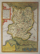
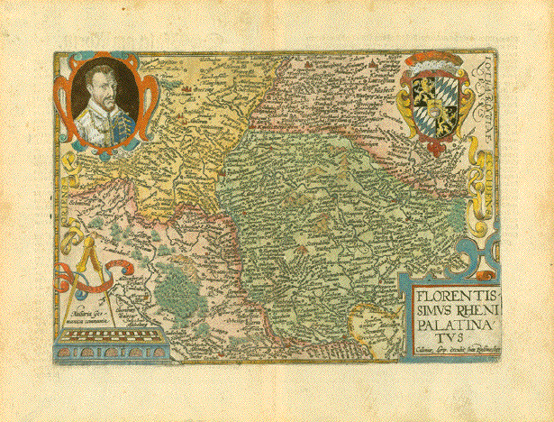
"Florentissimus Rheni Palatinatus" Copper engraving published by
Joan Bussemacher for Matthias Quad ca 1600 in Cologne. In the lower left is the
mileage chart dated 1592. In the center of the map is
Speyer. On the reverse side is
historical German text about the region shown on the
map. Pleasant hand coloring. Map image is in good condition. Vertical centerfold. The margins have light browning
and normal signs of age and use. Map image: 19.6 x 28.2 cm ( 7.4 x 11.1") $ 270.00 minus 30% Discount = $ 189.00 Order Nr. DEUTSCHLAND256718 |
|
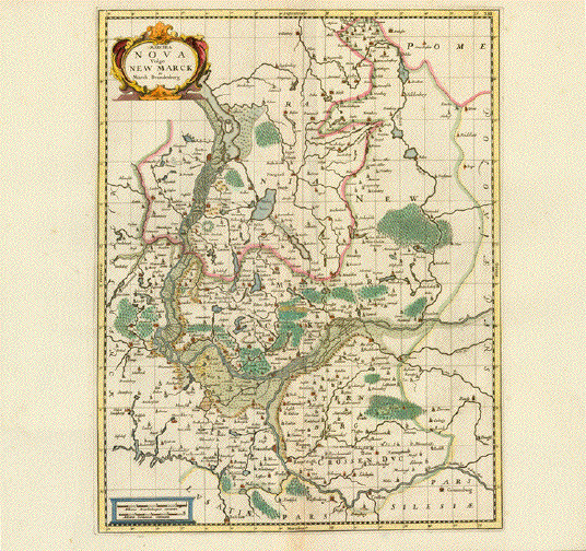
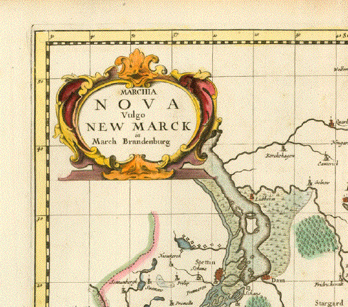
Marchia Nova Vulgo New Marck in March Brandenburg" Hand-colored copper engraving by Moses Pitt and Stephan Swart. Published in Amsterdam, 1695. This attractive map is rather rare. Map is in good condition except
for a crease parallel to the vertical centerfold. 49 x 37.5 cm (19.2 x 14.7 ") $ 280.00 Order Nr. DEUTSCHLAND244752 |
|
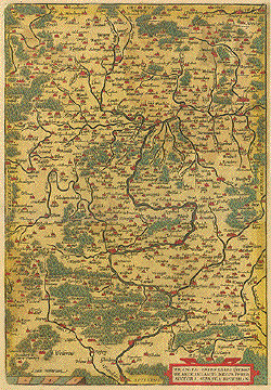
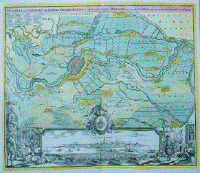
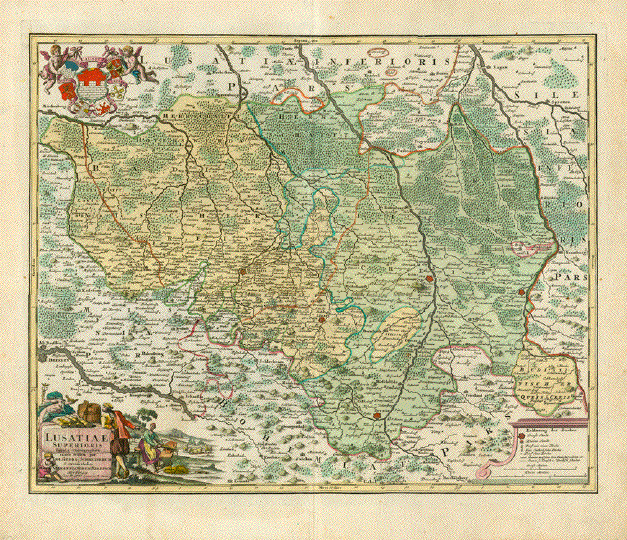
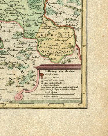
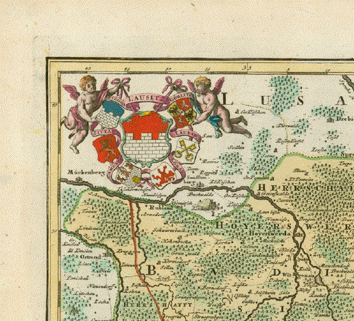
"Lusatiae Superioris Tabula Chorographa exacte tradita per Joh, Georg Schreiberum & excus studio" Copper engraving of the
Oberlausitz by Johann Georg Schreiber (1676-1750)).
Published in Nuremberg. The title cartouche shows
prodects of the area with Mercury overlooking the peceful
scene. Wide margins. The map is in good condition . The margins show minor signs of age and use. 44 x 55 cm ( 17.3 x 21.6 ") Order Nr. DEUTSCHLAND243247 SOLD |
|
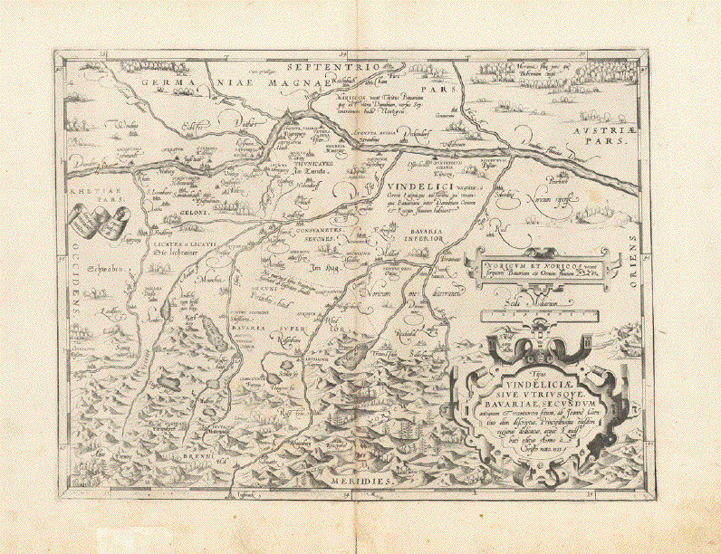
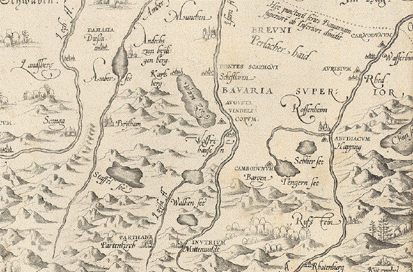
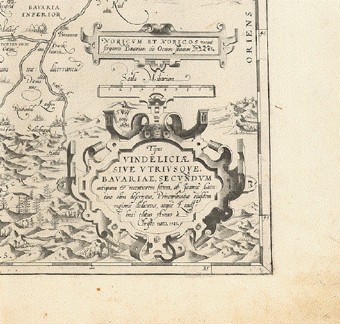
"Tipus Vindeliciae sive utriusque Bavariae, secundum antiquum et recentiorem situm ab Joanne Aventino olim descriptus, Principibusque eiusdem regionis dedicatus, atque Landshuti editus Anno a Christo nato, 1533" Kupferradierung nach der Vorlage von Johann Georg Turmair, latinisiert Johannes Aventinus (1477 Abensberg - Regensburg 1534). Aventinus schuf 1523 die erste Landkarte von Bayern. Von ihr gab es einen höchst dekorativen Holzschnitt, umrahmt von Wappen bayerischer Städte. 1533 erschien ein Kupferstich von dieser Karte ohne die Umrandung mit dem Titel der Karte in einer typischen Renaissance-Kartusche. Abraham Ortelius (1527-1598), der 1570 den ersten Weltatlas "Theatrum Orbis Terrarium" in Antwerpen herausgab, erwarb und benutzte diese Kupferplatte für die erste Ausgabe seines Atlas. Obwohl dieser Atlas erst 1570 erschien, wurde die Jahreszahl 1533 natürlich mutgedruckt. Schon während der ersten Auflage erfuhr Ortelius von der sehr viel präziseren Bayernkarte von Philipp Apian (1531-1589). Er erwarb die Rechte zum Abdruck, während der 1571 erschienenen Auflage des "Theatrums" und ersetzte mitten im Druck die Aventinische Karte gegen die Apiansche Karte aus. So kam es, dass die Bayernkarte von Johannes Aventinus nur in sehr geringer Zahl gedruckt wurde (1570 die ganze Auflage und 1570 in Teilausgabe). Das macht die Aventunus-Karte zu einer äusserst seltenen und begehrenswerten Karte. Vindelicien war der Name der römischen Provinz, die im 4 Jahrhundert im Zuge der Reichsreformen Kaiser Diokletians so benannt wurde. Sie umfasste Teile des heutigen bayerischen Schwabens, Oberbayerns und Niederbayerns. Augsburg trug damals den Namen Augusta Vindelicorum. Die Karte führt die deutschen Städtenamen und, wo vorhanden, die römischen Bezeichnungen. In der West-Ost-Ausdehnung zeigt die Karte von Rain an Lech und Donau sowie Füssen bis Peurbach an der Donau bis St. Wolfgang im Salzkammergut. Im Norden reicht die Karte von Cham bzw. Furt im Wald bis Innsbruck. In München gibt es eine Katholische Deutsche nichtschlagende Studentenverbindung namens "Vindelicia". Leichte Altersbräunung. Weite Margen. In der unteren Marge einige Restaurierungen. Die Karte selbst in sehr gutem Zustand. 32,7 x 43 cm Order Nr.DEUTSCHLAND242797 SOLD Reverse side:
|
|
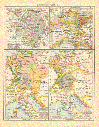
"Napoleonische Zeit I ") Four maps show the various political changes in Europe that came as a result of the Napoleon Wars. Published 1896. Horizontal centerfold. 29 x 22.5 cm ( 11.4 x 8.8 ") $ 60.00 Order Nr. DEUTSCHLAND248721 |
|
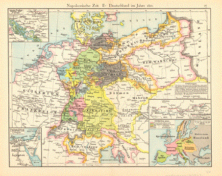
"Napoleonische Zeit II: Deutschland im Jahre 1812" This map shows Europe as it was
in 1812 as a result of the Napoleon invasions. Map was published 1896. Vertical centerfold. 22.5 x 29 cm ( 8.8 x 11.4 ") $ 60.00 Order Nr. DEUTSCHLAND248722 |
|
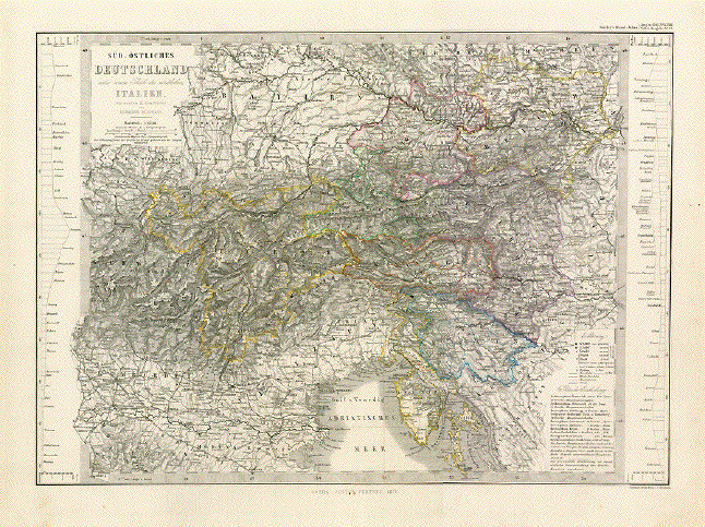
"Sued - Oestliches Deutschland nebst einem Theile des noerdlichen Italian" Steel engraving by W. Alt, Berge and C. Jungmann after Herman Berghaus for Stieler. Dated 1871. Original hand outline coloring. Interesting historical map extending as far north as part of Franconia and the Czech Republic. The path of the Danube is clearly visible and reaches as far as Pressburg on the right side. In the lower right is part of Istria and Croatia. In the lower left is Genoa (Genua), Alessandria, and Bologna. On the left side is a diagram showing the distances of various towns between Munich and Mantua. On the right side is a diagram showing the distances of many towns between Glocknitz and Trieste. Also shown on the map are railroad lines. Map has light age toning. There is a repair on the lower part of the centerfold. 29 x 40.5 cm ( 11.4 x 15.9 ") $ 85.00 Order Nr. ITALIAMAPPA238210 |
|
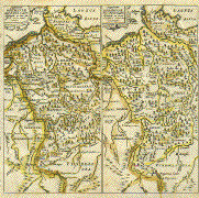
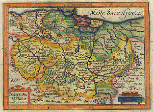
"Brandenburg et Pommerania". Copper etching in excellent modern coloring. By Peter Kaerius (1571-1646). Amsterdam, ca 1620. Berlin is located in the center of this map showing the regions of Brandenburg and Pomerania. In the northwest is Schwerin, in the southwest Lauburg with Furstenberg and Crossen in the southeast. In the east is the Oder river with its many tributaries. Verso: Text in latin. The map has a small wormhole in the lower orange border. In the upper left margin is a thin area in the paper that is visible only against the light. Otherwise the condition is Very Good. 13.8 x 18.8 cm ( 5.4 x 7.4 ") $ 250.00 Order Nr. DEUTSCHLAND1234SOLD |
|
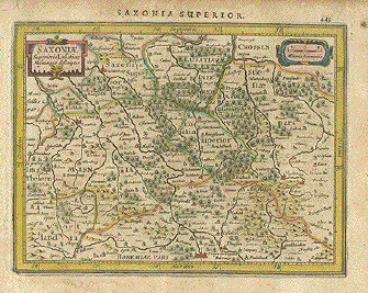
"Saxoniae Superioris Lusatiae". Copper etching by Peter Kaerius (1571-1646). Amsterdam, ca 1620. Verso text in Latin. Older hand coloring. Bischofswerda and Bautzen are in the center of this map. In the upper left is Wittenberg and Weissenburg. In the lower left is Hof and Egra. Prag is at the bottom center of the map as a red symbol of the city. In the lower right is part of the Elbe river and Zampach. In the upper right are Glogau and Fraustadt. Map has overall age toming and scattered spotting in margins. Margin edges are brown. Hardly noticeable spotting in image. General condition is Good. 13.8 x 18 cm ( 5.4 x 7 ") Order Nr. DEUTSCHLAND 1327SOLD |
|
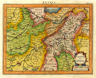
"Clivia, Cleve et Muers".
Copper etching in very pleasant
modern coloring. By Peter Kaerius (1571-1646). Amsterdam, ca
1620. This west-oriented map is dominated by the
courses of the rivers Rhein and Maas and all their
tributaries. The Rhein enters the map in Except for one repaired worm hole at the bottom in the orange margin, the map is in Almost Exccellent condition. 14.3 x 18.1 cm ( 5.6 x 7.1 ") $ 170.00 Order Nr. DEUTSCHLAND 1197 |
|
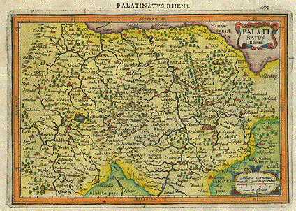
"Palatinatus Rheni". Copper etching in very pleasant modern coloring. By Peter Kaerius (1571-1646). Amsterdam, ca 1620. Verso text in Latin. Under the title cartoche in the upper right flows the Main river. In the upper center it flows into the Rhine at Mainz. The Rhine "flows" into the map at the bottom south of Gemersheim. On the left side is Saarbrücken and the Saar river. A bit north on the left is Birkenfeld. In the lower right above the map legend is Heilbronn. Map has a repaired wormhole in lower orange border. Light offsetting outside orange border. Overall condition is Almost Very Good. 13.9 x 20.2 cm ( 5.4 x 7.9 ") $ 170.00 Order Nr. DEUTSCHLAND 1255 |